Clear Sky Science · en
Development and optimization of a morphodiversity model for mountainous areas using supervised classification and artificial neural networks
Why the Shape of Mountains Matters
When we think about protecting nature, we usually picture rare plants and animals. But the ground beneath them—the cliffs, valleys, ridges, and river gorges—quietly shapes where life can thrive. This paper explores how to measure that physical variety, called morphodiversity, in a precise and automated way. Focusing on Poland’s Pieniny Mountains, the author shows how modern computer techniques, including artificial neural networks, can turn detailed elevation data into reliable maps that help guide conservation and land‑use planning.
A Mountain Laboratory for Landscape Variety
The Pieniny Mountains, straddling the Polish–Slovak border, are a compact but remarkably diverse range. Steep limestone cliffs, deep gorges like the famous Dunajec River Gorge, gentler flysch slopes, volcanic rocks, and flat basin floors all sit side by side. This mix of rock types and landforms creates a patchwork of habitats, from sunny crags to shaded valleys, which in turn supports rich biodiversity. Because the area has been mapped and studied in detail, it serves as an ideal “laboratory” for testing new ways to quantify how varied the landscape really is, far beyond what the eye can easily judge from a map or a viewpoint.
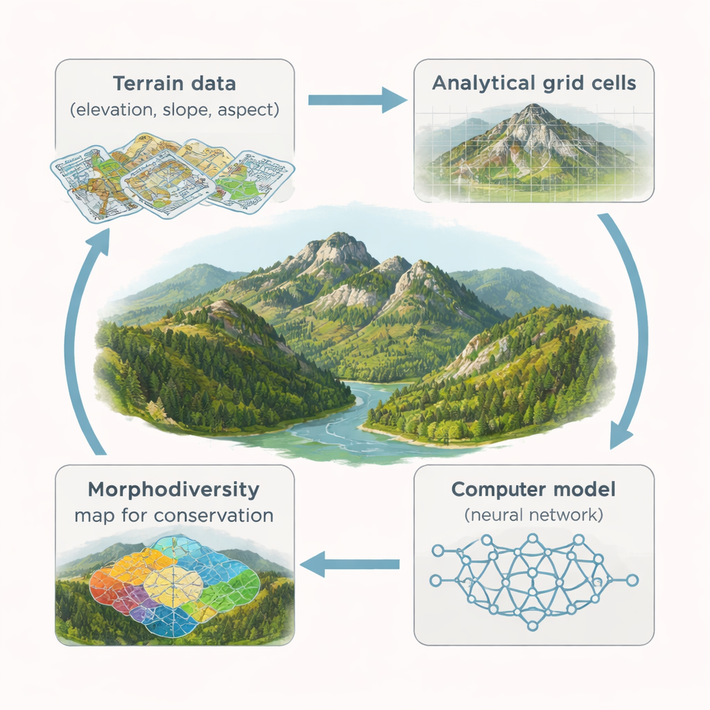
From Raw Elevation to Measurable Terrain Variety
The study starts with a high‑resolution digital elevation model, a detailed 3D description of the land surface. From this, the author derives seven basic terrain features: altitude, slope, aspect (the direction a slope faces), two kinds of curvature (how surfaces bend), local height differences, and the presence of rock outcrops. The region is then overlaid with thousands of regularly sized hexagonal cells. Within each cell, the computer measures how much these terrain features vary from pixel to pixel. Instead of simply counting how many “types” of landforms are present, the method treats variation itself as the signal: the more change in height, steepness, or direction within a cell, the more morphodiverse it is likely to be.
Training a Digital Classifier to Recognize Complex Terrain
To turn these numbers into a meaningful map, the study uses supervised classification and artificial neural networks—computer models loosely inspired by how brains learn patterns. Human experts first mark example cells as clearly “morphodiverse” (rugged peaks, rocky ridges, deeply incised valleys, dramatic gorge walls) or “non‑morphodiverse” (flat valley floors, lake surfaces, broad gentle slopes). These labeled examples teach the neural network what combinations of altitude, slope, and other features typically correspond to complex terrain. Once trained, the network assigns a probability to every cell in the region, indicating how likely it is to belong to the morphodiverse class. The result is a continuous map that can later be grouped into intuitive categories from very low to very high morphodiversity.
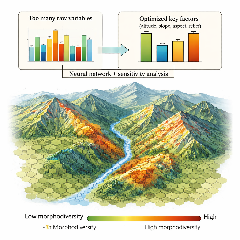
Pruning the Data to Keep Only What Matters
Older methods often added many terrain indicators together, unintentionally counting the same information multiple times and blurring the picture. This study tackles that problem by combining neural networks with global sensitivity analysis, a technique that tests how much each input actually contributes to accurate predictions. By gradually “switching off” variables and tracking changes in model error, the author identifies which features carry real information and which are largely redundant. The optimized models show that just a handful of factors—height differences within a cell, overall altitude, slope, the pattern of slope directions, and the presence of rock outcrops—are enough to capture the essential structure of morphodiversity. Even after removing low‑value inputs, the simplified models still match the full versions extremely closely, with correlation values as high as 0.96–0.98.
What the Results Mean for Nature Protection
The refined model, especially the RCMSC–ANN–M version, produces maps that line up well with geomorphologists’ understanding of the Pieniny landscape. It highlights not only the spectacular high ridges and gorge walls, but also morphologically complex areas in valley sides and foothills that might otherwise be overlooked. Because the method is based on widely available elevation data and a compact set of key variables, it can be adapted to other mountain regions around the world. For conservation planners, this offers an objective way to locate and compare “geologically rich” areas that underpin biodiversity and scenic value, helping to prioritize where protection, tourism management, or detailed field surveys should focus.
Citation: Bartuś, T. Development and optimization of a morphodiversity model for mountainous areas using supervised classification and artificial neural networks. Sci Rep 16, 6009 (2026). https://doi.org/10.1038/s41598-026-36326-3
Keywords: geodiversity, morphodiversity, mountain landscapes, neural networks, geoconservation