Clear Sky Science · en
Identifying ecological restoration zones based on ecological security patterns in a resource transitioning district
Why damaged mining landscapes matter to everyday life
Across the world, cities built on coal and other minerals often pay a hidden price: sinking ground, polluted water, and shrinking green space. These changes don’t just scar the land; they quietly weaken the natural systems that clean our air and water, protect against floods, and support food production. This study looks at Tongshan District in Xuzhou, eastern China—a classic mining city in transition—to show how science can guide smarter ecological repair so that people, nature, and the local economy can all do better together. 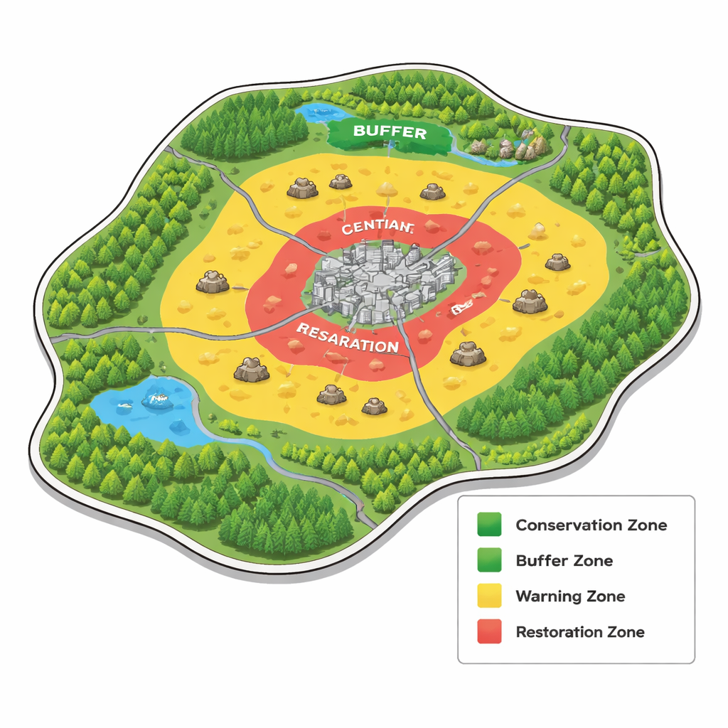
From coal country to greener ground
Tongshan surrounds Xuzhou’s urban core and has long been carved up by mines, subsidence pits, and sprawling construction. At the same time, it is an important ecological barrier made up of farmland, forests, and lakes. The authors wanted to answer a practical question: where should limited restoration funds go first to get the greatest ecological benefit? To do this, they built an “assessment–pattern–zoning” framework. First they measured how well the landscape was performing key ecological “jobs,” such as supplying clean water, preventing soil loss, storing carbon, and supporting wildlife. Then they mapped how easily plants and animals could move through the district. Finally, they divided the land into zones that call for different levels of protection or repair.
Taking the pulse of nature’s services
The team examined four time points—2005, 2010, 2015, and 2022—using the widely used InVEST computer model together with satellite data and local maps. They calculated five main ecosystem services: water yield (how much water landscapes hold and release), habitat quality, carbon storage in plants and soil, carbon fixation and oxygen release by vegetation, and protection against soil erosion. They combined these into a comprehensive ecosystem service index, which shows the overall ecological “health score” for each location. Over nearly two decades, many of the best-performing areas lay in the forested and garden landscapes of the northeast and south, while urban cores and heavily mined zones consistently scored poorly. On average, the index followed an N-shaped curve, with a striking drop around 2010—when Tongshan shifted from county to district status and construction land rapidly replaced cropland and forest.
Mapping ecological lifelines and pressure points
Next, the researchers turned their attention to how easily nature can flow across the land. They picked out “ecological sources”—patches that always ranked as extremely important for ecosystem services across all years—and treated them as strongholds for biodiversity and key natural functions. Then, using a method inspired by electrical circuits, they calculated a “resistance surface” that shows how much different features, such as highways, dense housing, mine subsidence areas, steep slopes, and bright nighttime lights, block the movement of species and ecological processes. This revealed 126.6 square kilometers of ecological sources, 147 corridors totaling about 592 kilometers, and dozens of pinch points and barrier areas where corridors squeeze through narrow gaps or are severed, especially in built-up and mining-affected parts of the district. 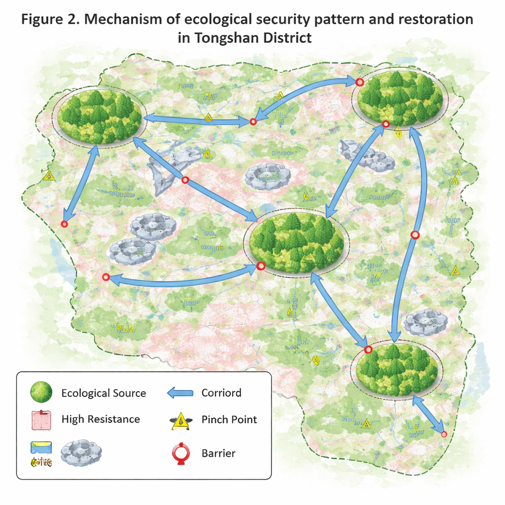
Four zones for smarter restoration
To turn these maps into action, the authors built a simple zoning index that blends three elements: how strong ecosystem services are today, how hard it is for ecological processes to move (the resistance), and whether conditions have been getting better or worse over time. Using this index, they divided Tongshan into four ecological zones. Buffer zones, where conditions are generally good but still vulnerable, cover more than half the district and represent a huge opportunity to keep nature functioning well with modest effort. Conservation zones, about one-tenth of the area, are the “crown jewels” of forests and productive farmland that need strict protection. Warning zones are places where nature is under strain and could deteriorate without preventive measures. Restoration zones—just over 5% of the land—are the most degraded, often overlapping with mine subsidence and dense construction, and require urgent, focused repair.
What this means for people and policy
For residents and planners in Tongshan and other resource-based cities, the message is clear: ecological restoration works best when it is guided by where nature is still strong, where it is breaking down, and how people are reshaping the land. The study shows that while past restoration projects have helped in some areas, large portions of the landscape remain in a fragile middle state—neither pristine nor ruined—where smart management can tip the balance. By combining ecosystem service assessments with movement pathways for wildlife and clear zoning rules, the framework offers a practical roadmap: protect high-functioning zones, reinforce buffers, act early in warning areas, and concentrate heavy restoration in the most damaged hotspots. In doing so, cities emerging from a mining past can rebuild healthier landscapes that better support everyday life, from safer water and soils to more livable neighborhoods.
Citation: Ma, Y., Wang, R., Wang, Y. et al. Identifying ecological restoration zones based on ecological security patterns in a resource transitioning district. Sci Rep 16, 5829 (2026). https://doi.org/10.1038/s41598-026-36110-3
Keywords: ecological restoration, ecosystem services, mining city, land-use change, spatial planning