Clear Sky Science · en
An improved PSO-ABC path planning algorithm for UAVs based on a construction of urban airspace topology with actual GIS data
Safer skies for city drones
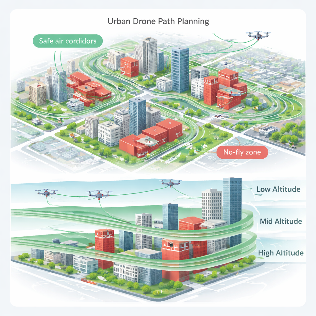
Delivery drones and inspection robots promise faster packages and smarter cities, but flying them over crowded streets and tall buildings is risky. This study shows how to build “invisible highways” in the sky above a real Chinese city and how a new computer algorithm can guide unmanned aerial vehicles (UAVs) along routes that are both safe for people on the ground and efficient for the aircraft.
Turning a real city into a 3D flight map
The authors start with detailed geographic information system (GIS) data from a 5-by-5–kilometer area in Changqing District of Jinan, China, including the exact locations and heights of buildings. Instead of treating the air above the city as one big space, they slice it into nine thin altitude layers, each 5 meters tall, from ground level up to 40 meters. Within each layer, they lay down a checkerboard of 100-by-100–meter squares. Stacking these squares creates a 3D grid of tiny boxes, or voxels, each representing a potential patch of sky a drone could occupy.
Balancing open air with people and property below
To decide which voxels are actually usable, the team combines two simple but powerful ideas. First, “airspace availability” measures how easily a drone could move from one grid square to another without running into buildings or other obstacles. If a square connects to many others through open corridors, it scores high. Second, “ground risk” measures how much harm a falling drone could cause below, based on local population density, traffic, and the presence of valuable structures. The model distinguishes between deaths or injuries to pedestrians and vehicle occupants and damage to buildings and infrastructure.
Sorting the city into better or worse drone zones
Each location in the grid gets two scores: one for airspace availability and one for ground risk. The authors then use a quadrant diagram to group air patches into four types: high availability with low risk (ideal), high availability with high risk (busy city centers), low availability with low risk (few people but many obstacles), and low availability with high risk (the worst of both worlds). Threshold values mark what counts as “high” or “low.” Most of the studied airspace—about 64 percent—falls into the best category, with plenty of room to maneuver and relatively low danger to people and property. A more advanced “Pareto sorting” step then ranks the best cells by trading off higher openness against lower risk, keeping the top half as the preferred network of safe sky corridors.
Teaching drones to choose smarter paths
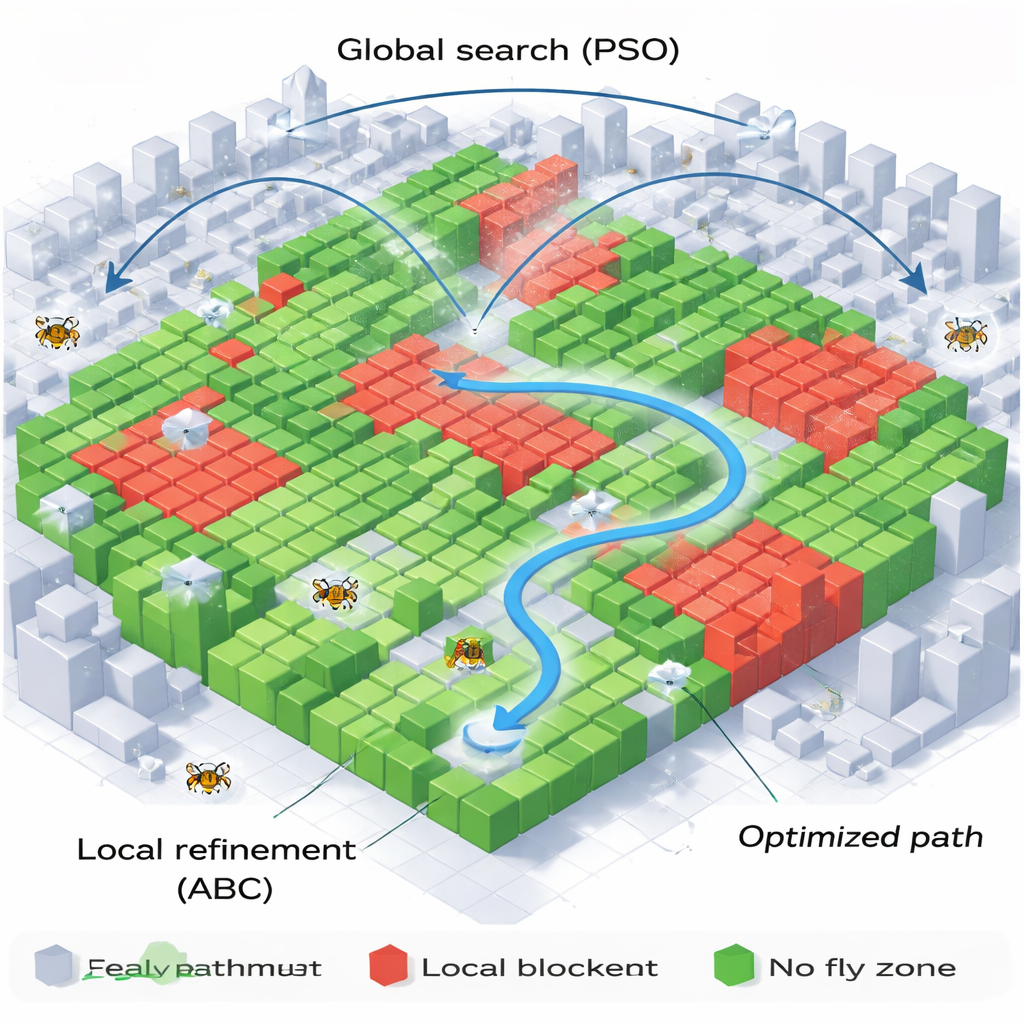
Once this safe 3D network is built, the challenge is to find a specific route from a starting point near the ground to a destination higher up, while obeying strict rules: drones must avoid marked no-fly zones above buildings, stay within allowed altitude bands, limit steep climbs and dives, and keep a safe distance from the terrain and structures. To do this, the authors blend two well-known search techniques inspired by nature. A particle swarm optimization (PSO) method acts like a flock of birds exploring the whole space for promising paths, while an artificial bee colony (ABC) method behaves like bees that focus on refining the best nectar sources. PSO performs a broad global search, then ABC performs careful local tuning around the most promising candidate routes. Finally, the rough waypoint chain is smoothed using a mathematical curve so that a real drone can fly it without sharp, unrealistic turns.
Faster, smoother, and safer city routes
The researchers test their combined PSO-ABC approach against three common alternatives: a standard genetic algorithm, PSO alone, and ABC alone. In realistic simulations using the actual building layout of Changqing, their method consistently finds smoother flight paths that avoid all no-fly zones and crowded ground areas. It also converges on good solutions much more quickly—using roughly half as many iterations as the other methods—to reduce wasted computation time and energy. To a non-specialist, the bottom line is clear: by carefully modeling both the sky and the city below, and by using a smart mix of bird-like and bee-like search strategies, this work offers a practical way to guide drones through complex urban environments while keeping people and property safer.
Citation: Liu, Y., Dong, H., Liu, H. et al. An improved PSO-ABC path planning algorithm for UAVs based on a construction of urban airspace topology with actual GIS data. Sci Rep 16, 5048 (2026). https://doi.org/10.1038/s41598-026-35958-9
Keywords: urban drone routing, UAV path planning, airspace safety, heuristic optimization, GIS-based airspace