Clear Sky Science · en
Stratigraphic and structural architecture of the inner ramp carbonates in the Northern Galala Plateau, Egypt: synergizing remote sensing and field data
Ancient Seafloor Beneath a New City
A new highway crossing Egypt’s Northern Galala Plateau, above the Red Sea coast, has sliced through rocks that were once a shallow tropical sea. This paper uses satellite images and on-the-ground geology to read that rocky roadcut like a history book. The story is not just academic: these carbonate rocks are the same kind that host major oil and gas fields and freshwater aquifers around the world, and they help planners understand how stable the ground is beneath fast-growing New Galala City.
A Shallow Sea Turned to Stone
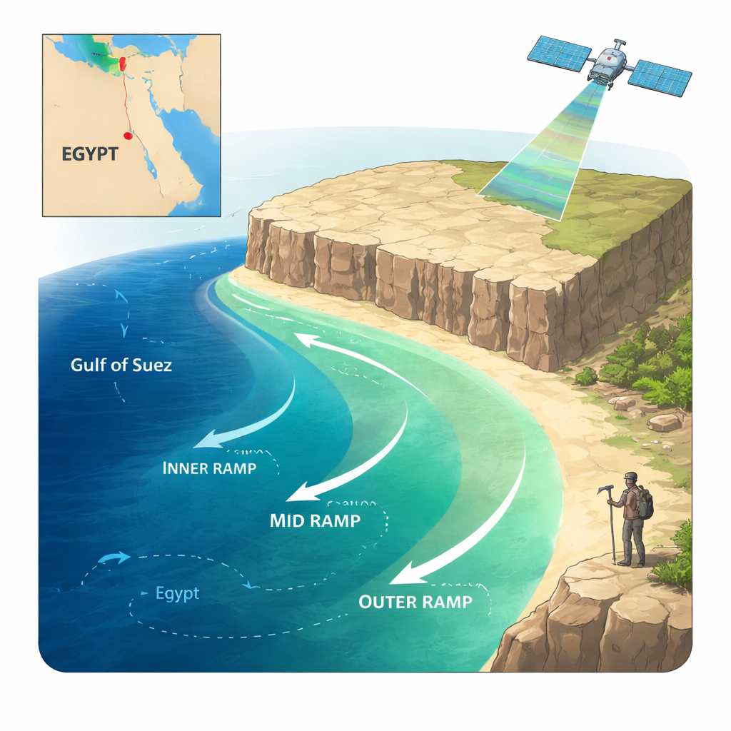
Fifty to sixty million years ago, during the transition from the Paleocene to the Eocene, the area now forming the Northern Galala Plateau lay under a warm, shallow arm of the ancient Tethys Ocean. Instead of sand and mud, the seafloor was built largely from lime produced by algae, tiny shelled creatures, and chemical precipitation. Geologists call this a carbonate platform. The innermost part of that platform, closest to land, was very shallow—often just a few meters deep—and was repeatedly exposed and flooded as sea level and climate shifted. Over time, these sea-floor sediments were buried, hardened into rock, and later lifted high above sea level by slow bending and breaking of the Earth’s crust.
Reading Rocks from Space and on Foot
The authors combined modern remote sensing with classic fieldwork. They processed images from NASA’s Landsat-9 satellite and Europe’s Sentinel‑1 radar to pick out subtle color and texture differences that reveal where one rock unit ends and another begins, and where hidden fractures cut through the plateau. These satellite-based “eyes in the sky” were checked and refined by detailed measurements, sampling, and microscope work along the new road. This joint approach showed that rocks previously lumped together actually fall into distinct belts on the ancient sea floor, and that the plateau is crisscrossed by faults and fractures tied to a larger regional fold-and-fault system known as the Syrian Arc.
Three Rock Stories in One Cliff
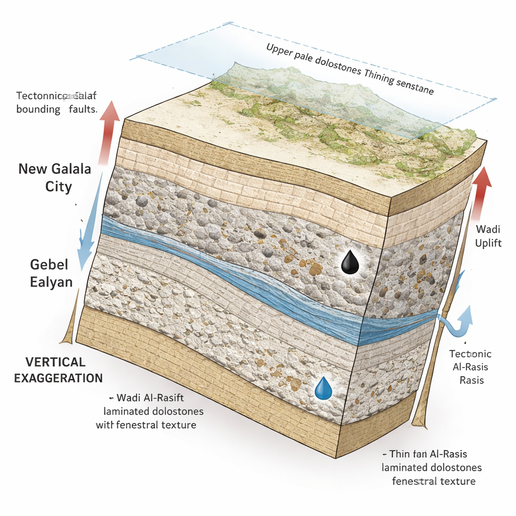
Using these tools, the team formally split the Southern Galala Formation—the main rock body at the top of the plateau—into three members, each telling a different chapter of the shallow-sea story. At the base, the Wadi Al‑Rasis Member consists of pale, thinly layered dolostone with microbial mats, mud cracks, and tiny bubble-like cavities. These features point to tidal flats and salty coastal flats that were often exposed to air. Above it, the Gebel Ealyan Member is made of thicker, grey limestones packed with large bottom-dwelling foraminifera and other fossils, and shows evidence of karst—dissolution cavities and cave-like voids formed when rainwater later ate into the rock. This interval records a restricted lagoon and nearby shoals where waves and currents concentrated skeletal fragments. Capping the sequence, the New Galala City Member returns to pale dolostones with thin sandstone streaks, again reflecting very shallow, tidally influenced settings at the inner edge of the platform.
Shaping by Faults, Fractures, and Chemical Change
The Galala platform did not evolve in calm conditions. The region sat above a gentle arch in the crust and was squeezed and tilted as Africa inched toward Eurasia. Satellite-derived lineament maps and field observations show networks of faults trending mainly north‑northeast, with additional northeast and northwest sets that together built up anticlines, step-like fault blocks, and zones of intense fracturing. These structures helped lift parts of the seafloor, periodically exposing the carbonates to rainwater. At the same time, slow chemical changes—collectively called diagenesis—reworked the rock: microbes turned shell fragments into fine lime mud, mineral-rich waters cemented grains, and magnesium-rich brines converted limestone to harder, more porous dolostone. Dissolution carved out vugs, molds, and karst cavities, while pressure at depth squeezed grains together and dissolved material along seams.
Why These Rocks Matter Today
Because of this interplay of environment, tectonics, and chemistry, the inner-ramp carbonates of the Southern Galala Formation now have a complex architecture of layers, pores, and fractures. That architecture makes them prime candidates to store and transmit fluids such as oil, gas, and groundwater—and also affects how stable they are as a foundation for roads and buildings. Grain-rich shoals preserve good original pore spaces, dolomitization adds intercrystalline porosity, and karst processes open up larger voids and channels. By tying together satellite imagery, structural mapping, and microscopic rock analysis, this study shows how a modern desert plateau preserves the imprint of an ancient tropical sea and provides a guide for exploring similar carbonate systems elsewhere in the world.
Citation: Fathy, M.S., Abd El‑Wahed, M.A., Faris, M. et al. Stratigraphic and structural architecture of the inner ramp carbonates in the Northern Galala Plateau, Egypt: synergizing remote sensing and field data. Sci Rep 16, 5269 (2026). https://doi.org/10.1038/s41598-026-35896-6
Keywords: carbonate platform, remote sensing geology, Northern Galala Plateau, tectonic uplift, karst reservoirs