Clear Sky Science · en
Sequence of events that led to the South Lhonak lake outburst flood in Sikkim, India
Why a Himalayan Lake Disaster Matters to Us
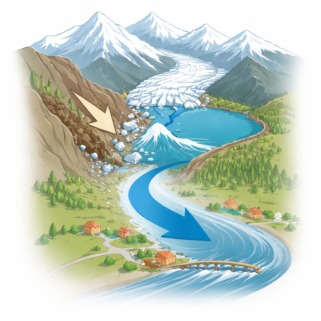
In October 2023, a high‑mountain lake in the Indian state of Sikkim suddenly burst, sending a wall of water and debris roaring down the Teesta River valley. Dozens of people died, bridges and a major hydropower plant were destroyed, and tens of thousands were affected. This study unpacks, in forensic detail, what actually set off that disaster at South Lhonak Lake. By tracing the chain of events, the researchers show how a changing mountain landscape can quietly store risk for years before releasing it in a single terrifying night—and what must be watched to reduce future danger.
A Growing Lake in a Warming Mountain World
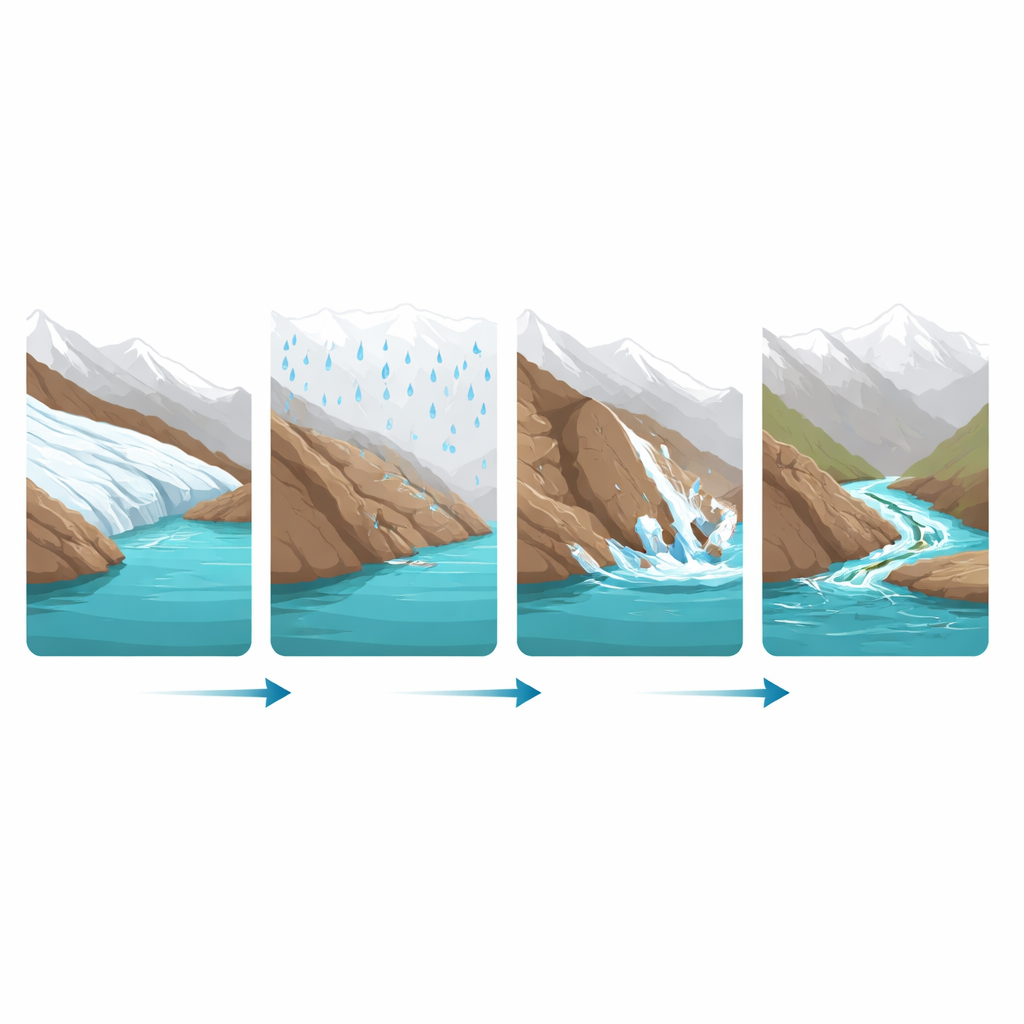
South Lhonak Lake sits more than five kilometers above sea level in the Eastern Himalaya, where a retreating glacier has left a deep basin now filled with meltwater. Like many such lakes around the world, it has been expanding for decades as the glacier shrinks and calves ice into the water. Earlier surveys showed the lake’s area had grown roughly eightfold since the 1970s, and by 2016 it held on the order of tens of millions of cubic meters of water behind a natural dam made of loose rock and soil, called a moraine. The surrounding terrain is steep and prone to landslides, making the lake a known hazard long before the 2023 flood.
Looking for the Real Triggers
After the disaster, early reports blamed intense rain, rapid ice break‑off and slope failures around the lake. But most of those accounts focused on downstream damage, not on what actually pushed the lake past its breaking point. In this study, the authors combine satellite images, radar measurements, rainfall estimates and simple flood formulas to reconstruct the timing and scale of each potential trigger. They ask two main questions: which processes were involved, and which ones mattered most? By ruling out some suspects and quantifying others, they aim to move beyond vague attributions to a concrete sequence of causes.
Hidden Weakening of the Lake’s Natural Dam
Years before the flood, the land around the lake was already shifting. Radar data from 2017 to 2021 show that the ice‑free ground near the lake, especially the left‑hand moraine beside the glacier front, was slowly sinking by roughly two centimeters per year. This likely reflects buried ice within the ridge melting away, gradually hollowing and loosening the structure. At the same time, the glacier was retreating rapidly and calving ice into the lake, which encouraged the water body to extend further along the glacier’s side and overdeepened bed. Streams carrying meltwater from nearby ice and another upstream lake cut channels through the same vulnerable moraine, further eroding and saturating it. Moderate precipitation in late September and early October 2023 added more water to this fragile mix, but detailed weather analyses show there was no cloudburst or extreme downpour directly over South Lhonak at the critical time.
The Night Everything Gave Way
On October 4, 2023, the weakened slope finally failed. A large landslide from the left lateral moraine plunged an estimated 38 million cubic meters of loose rock and soil into the lake. Almost simultaneously, part of the glacier’s front broke off, dropping around 7 million cubic meters of ice into the water. The combined mass, equivalent to displacing about 45 million cubic meters of lake water, generated powerful waves that slammed into the lake’s front moraine dam. Calculations using standard dam‑break formulas show the lake held more than 100 million cubic meters of water before the event, and once overtopping began, the dam likely failed within a couple of hours. The resulting Glacial Lake Outburst Flood rushed down the valley, raising downstream river levels by several meters and tearing out homes, roads, bridges and a hydropower plant along the way.
What Wasn’t to Blame
The team also examined two commonly cited culprits: heavy rain and earthquakes. Satellite‑based rainfall products and high‑resolution weather model runs reveal that the heaviest rains during early October fell over southern Sikkim and neighboring lowlands, not over the northern high‑mountain basin where South Lhonak sits. There were moderate rains that contributed to snowmelt and wet ground, but not the kind of intense cloudburst that alone could explain a sudden overflow. Likewise, nearby earthquakes in the days before the event produced only very weak shaking at the lake, well below levels typically associated with triggering slope failures or disturbing lakes. The authors therefore conclude that neither heavy rainfall nor seismic activity was a primary trigger in this case.
Lessons for Safer Mountain Communities
To a layperson, this study shows that such disasters are rarely caused by a single dramatic event; they are more often the result of slow, creeping changes that go unnoticed until it is too late. At South Lhonak, years of glacier retreat, quiet sinking of the moraine, increasing lake volume and channels cutting through loose material set the stage. A single landslide that pushed rocks and ice into the lake was just the final shove. The authors argue that monitoring how fast lakes are growing and how quickly surrounding moraines are sinking or cracking could provide early warning of similar risks across the Himalaya. With many expanding glacial lakes located above densely populated valleys, keeping an eye on these hidden signs of instability may be one of the most effective ways to prevent future tragedies.
Citation: Mohanty, L.K., Gantayat, P., Dixit, A. et al. Sequence of events that led to the South Lhonak lake outburst flood in Sikkim, India. Sci Rep 16, 9741 (2026). https://doi.org/10.1038/s41598-026-35895-7
Keywords: glacial lake outburst flood, South Lhonak lake, Himalayan glaciers, landslide hazards, climate change impacts