Clear Sky Science · en
CNN-MLP framework for forest burned areas prediction using PSO-WOA algorithm
Why predicting fire damage matters
Wildfires are becoming hotter, larger, and more frequent as the climate warms and people expand into forested regions. For fire crews and local communities, one of the most pressing questions during an outbreak is not just whether a fire will start, but how much land it is likely to burn. This study shows how a new kind of artificial intelligence can take simple weather and drought measurements and turn them into highly accurate estimates of the final burned area, potentially giving emergency managers a stronger head start when every hour counts.
From raw weather data to fire impact
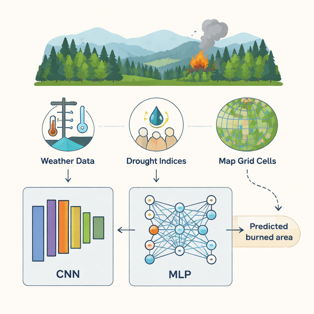
The researchers focus on a well-known dataset from a Portuguese national park that records 517 forest fires. For each fire, they know where and when it happened, the air temperature, humidity, wind speed, recent rain, and several fire weather codes that describe how dry different layers of forest fuel are. The challenge is that most fires in the record are tiny, while a few are very large, and the link between weather readings and burned area is highly tangled and nonlinear. Earlier methods, including standard machine-learning tools such as support vector machines and simple neural networks, struggled with this messy pattern and produced only modestly accurate predictions.
Letting algorithms decide which inputs matter
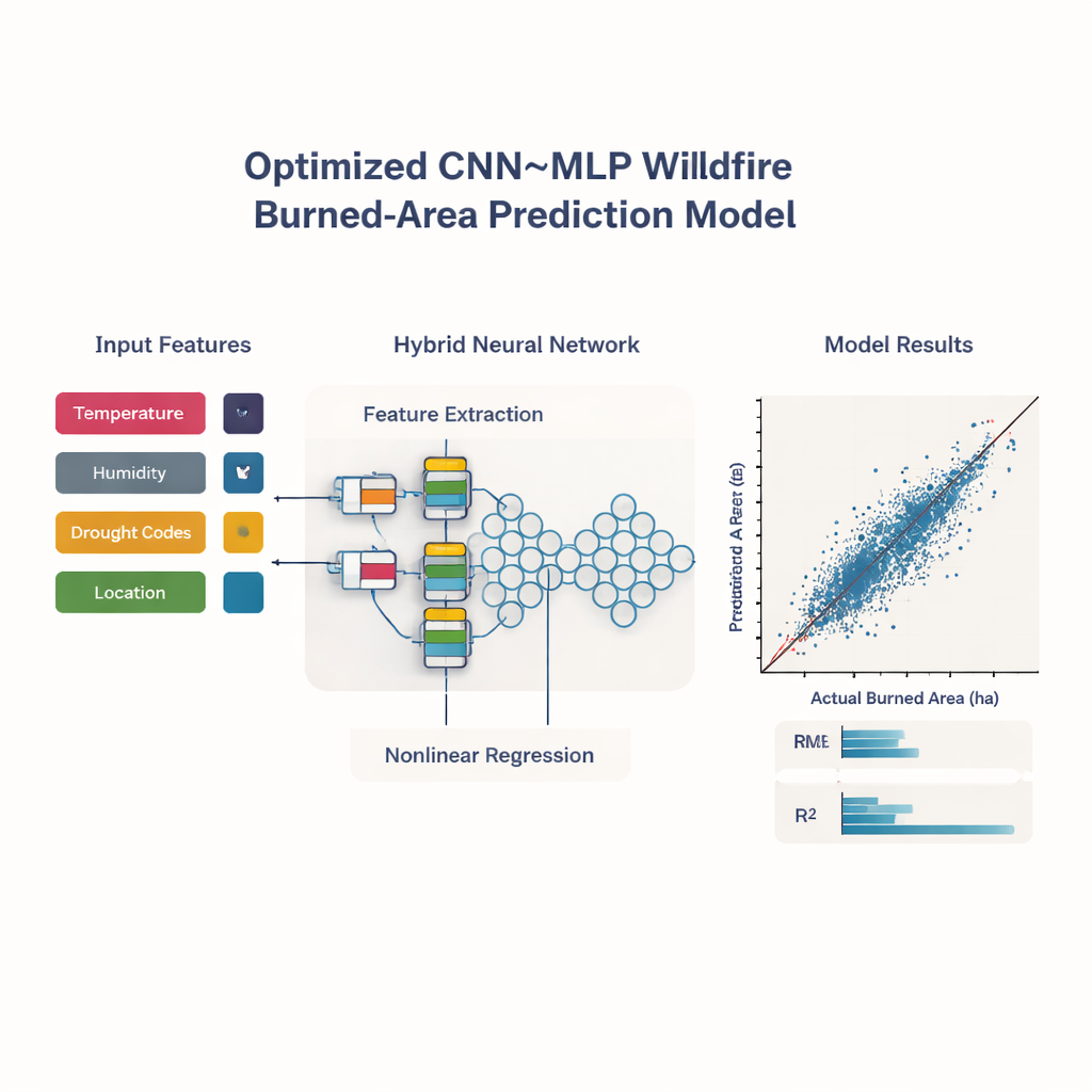
Instead of feeding every available variable into a model, the team first lets an algorithm inspired by fireflies search for the most informative combination of inputs. In this scheme, each "firefly" proposes a yes-or-no choice for each feature: include temperature, exclude rain, include one of the drought codes, and so on. Brighter fireflies represent combinations that yield more accurate predictions using a trial model while keeping the number of inputs small. Over many rounds, dimmer fireflies move toward brighter ones, and the process settles on a lean set of key factors. This procedure consistently highlights five main drivers of burned area: temperature, relative humidity, two drought measures that capture medium- and long-term dryness, and a simple coordinate indicating where in the park the fire occurred.
A hybrid neural network tuned by nature-inspired search
With those core inputs in hand, the authors build a lightweight but specialized neural network. One part, called a one-dimensional convolutional network, looks for patterns in how the selected features interact—such as the combination of high temperature, low humidity, and deep drought in certain locations. Its output then flows into a more traditional multilayer perceptron that performs the final regression step to estimate burned area. Choosing all the internal settings for this hybrid model—how many layers, how many neurons, how fast it learns—is itself a complicated problem. To handle this, the team combines two further nature-inspired search methods, one modeled on flocks of birds (particle swarm optimization) and the other on the hunting strategy of whales. Working in stages, these algorithms explore many possible network designs and gradually home in on those that minimize prediction error on held-out validation data.
Nearly perfect agreement with real fires
After this automatic tuning, the optimized hybrid model is put to the test against several strong deep learning contenders: stand-alone convolutional networks, classic feed-forward networks, and sequence-oriented models such as LSTMs and GRUs. All are trained and compared on the same data splits. The hybrid CNN–MLP system clearly comes out ahead. Its predictions match the observed burned areas with a coefficient of determination of about 99.9 percent, and its average errors—measured in hectares—are extremely small. Cross-validation, in which the data are repeatedly shuffled and split into different training and testing folds, shows that this performance is stable rather than a fluke of a lucky partition. Additional analyses using SHAP, a tool for explaining model decisions, confirm that higher temperatures and deeper drought push predictions toward larger burned areas, while higher humidity holds them back, echoing established fire science.
What this means for fire management
For non-specialists, the core message is that a carefully crafted combination of modern AI and optimization can turn a handful of routine weather and drought readings into very reliable estimates of how much forest a fire will likely consume. By automatically selecting the most telling inputs and fine-tuning the model’s inner workings, the approach offers both accuracy and interpretability. While the study focuses on one park in Portugal and a relatively small dataset, the framework can, in principle, be extended to richer data and other regions. As such systems mature and are linked to real-time weather feeds, they could help agencies prioritize high-risk zones, plan evacuations earlier, and allocate firefighting resources more efficiently, ultimately reducing the human and ecological toll of wildfires.
Citation: Mousa, M.H., Algamdi, A.M., Fouad, Y. et al. CNN-MLP framework for forest burned areas prediction using PSO-WOA algorithm. Sci Rep 16, 4982 (2026). https://doi.org/10.1038/s41598-026-35836-4
Keywords: wildfire prediction, burned area, deep learning, fire weather index, forest fire risk