Clear Sky Science · en
Spatiotemporal simulation of land use and land cover changes in Türkiye through a CA–Markov framework
Why changing landscapes matter to everyday life
Across the world, forests, farms, towns, and reservoirs are constantly reshaping the land. These shifts may feel distant, but they influence the water that reaches our taps, the food on our tables, the air we breathe, and the wildlife around us. This study zooms in on one district in western Türkiye to show, in detail, how human decisions and large infrastructure projects are transforming the countryside—and how computers can forecast where those changes are headed next.
A living map of forests, fields, and towns
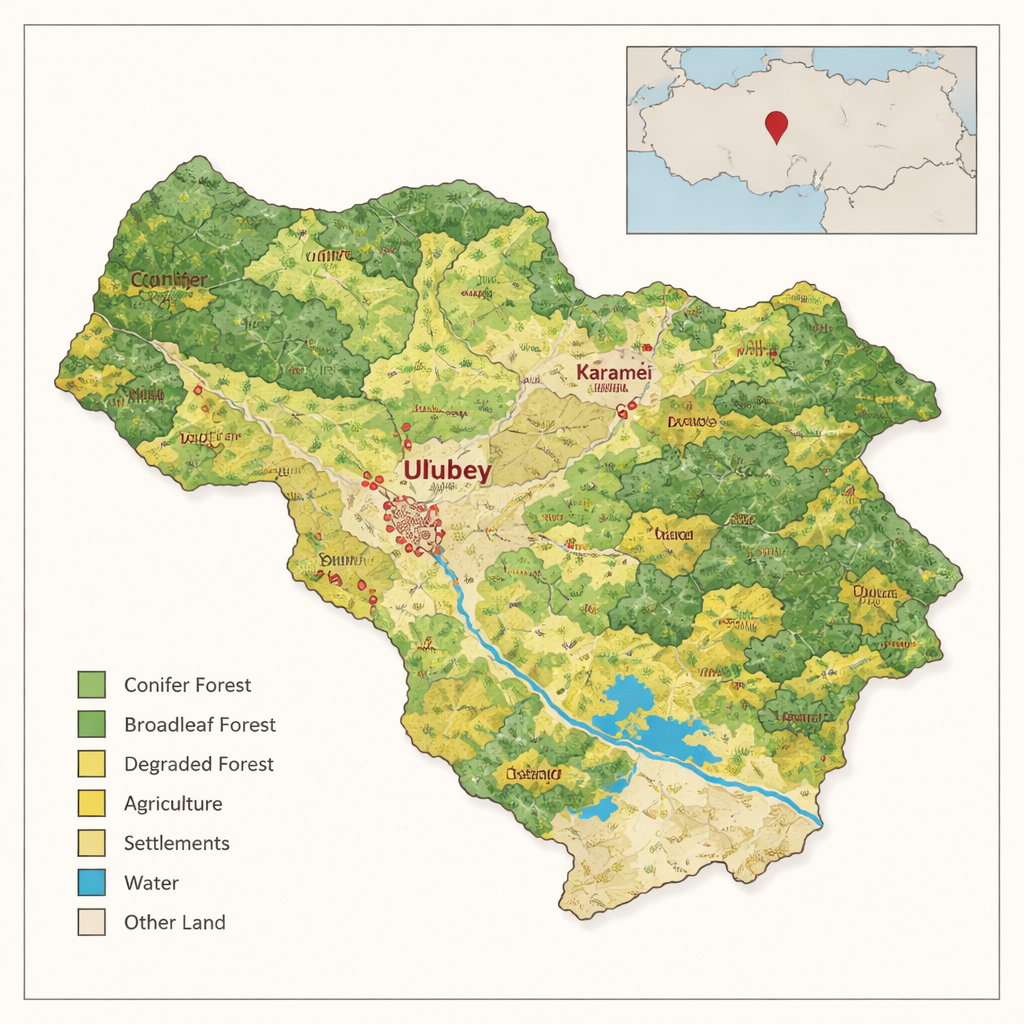
The research focuses on the Ulubey district in the Aegean Region of Türkiye, an area of canyons, dams, villages, and mixed Mediterranean–continental climate. Using detailed digital forest maps produced by the national forestry agency, the author grouped the land into nine easy-to-picture classes: dense conifer and broadleaf forests, mixed forests, sparse or degraded forests, forest clearings, agricultural land, settlements, water bodies such as dams, and a catch‑all category for rocky or pasture areas. These maps, available for 2001, 2013, and 2025, provided a rich snapshot of how people and nature have been reshaping the land over nearly a quarter century.
How computers replay the past to glimpse the future
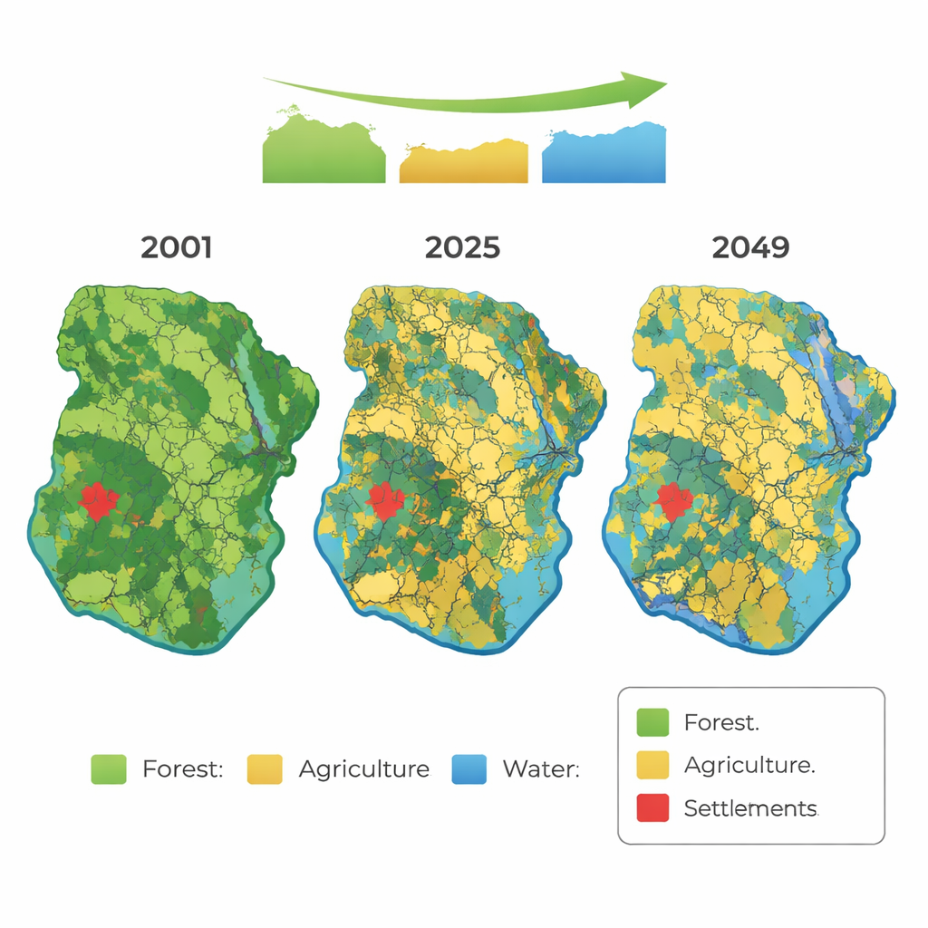
To turn past maps into a window on the future, the study used a combined “cellular automata–Markov” (CA–Markov) model within a geographic information system. In simple terms, the model chops the landscape into a fine grid of cells and learns how each type of land tends to turn into another over a fixed time step—for example, degraded forest becoming cropland or reservoir surface. It then applies those transition probabilities forward in time, while also taking into account how neighboring cells influence each other, so that forests, fields, or towns grow in realistic clusters instead of random pixels. By training on the 2001 and 2013 maps, the model produced a simulated map for 2025, which could be checked against the real 2025 forest map to see how well the method worked.
What has already changed on the ground
The comparison of 2001, 2013, and 2025 shows a clear story of pressure on forests. Total forest area—combining dense, mixed, and degraded stands—shrank by about 3,290 hectares, or almost 14 percent. The sharpest drop was in degraded forests, which fell by nearly a third. Some of this land was upgraded into healthier, denser forest after planting and rehabilitation, but large portions were converted to agriculture, other open land, or flooded by new dams. Mixed stands of red pine and oak almost disappeared, either submerged by reservoirs or simplified into single‑species pine or sparse woodland as local people harvested oak for fuel. At the same time, agricultural land outside forests grew modestly, settlement areas expanded by 68 percent, and water surfaces—mainly reservoirs behind new dams—grew more than fourfold.
Peering ahead to mid‑century
After confirming that the simulated 2025 map matched the real one with about 84 percent similarity and high statistical accuracy, the author used the same CA–Markov setup to project land use for 2037 and 2049. The outlook suggests continuing pressure on forests: by 2037, forest area is expected to fall by roughly 11 percent compared with 2025, and by about 21 percent by 2049. Degraded, conifer, and broadleaf forests are all projected to contract, while agricultural land could expand by 7 to 12 percent and water surfaces by nearly 15 percent. Settlement areas change less dramatically in percentage terms but still reflect a gradual outward push of human activity into formerly wooded landscapes.
What these shifts mean for people and nature
For non‑specialists, the takeaway is straightforward: in Ulubey, forests are slowly giving way to farms, dams, and built‑up areas, even as some restoration efforts improve patches of woodland. That trade‑off carries consequences for clean water, local climate, wildlife, and the ability of the land to store carbon. By showing that past changes can be simulated with reasonable accuracy, the study demonstrates that such models can act like a planning “forecast,” helping authorities test how different policies—about dams, mining, farming, or reforestation—might reshape the land in decades to come. In turn, that knowledge can guide decisions that better balance energy, food, and housing needs with the long‑term health of forests and the ecosystems they support.
Citation: Bozali, N. Spatiotemporal simulation of land use and land cover changes in Türkiye through a CA–Markov framework. Sci Rep 16, 5320 (2026). https://doi.org/10.1038/s41598-026-35807-9
Keywords: land use change, forest loss, Türkiye, remote sensing, CA-Markov modeling