Clear Sky Science · en
kNDVI reveals vegetation dynamics and hydro–edaphic controls in inner Mongolia (2000–2024)
Why this matters for dry lands and daily life
Across the world’s dry regions, from the American West to northern China, people depend on fragile grasslands and deserts for grazing, farming, and sandstorm protection. This study looks at Inner Mongolia, a vast dry region in northern China, to ask a simple but urgent question: is the vegetation getting healthier or slipping toward desert, and what is really driving those changes? Using a new way of reading satellite images, the authors show how hidden changes in groundwater, soils, and land use can make the difference between greening landscapes and long-term degradation.
A sharper lens on green growth
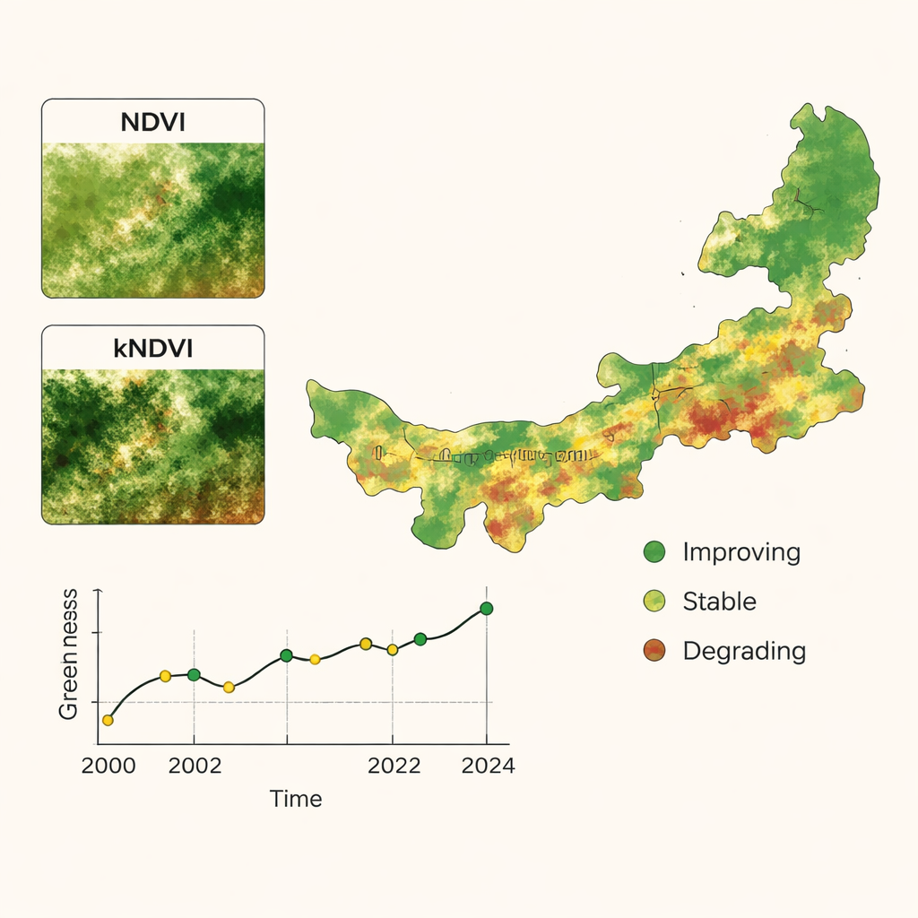
Most satellite studies use a popular measure called NDVI to judge how green the land is. But NDVI has blind spots: it struggles to separate thin, stressed plants from bare soil and tends to “max out” in lush areas, masking subtle shifts. The researchers instead focused on kNDVI, a newer index that uses ideas from machine learning to better stretch out the signal between very sparse and very dense vegetation. By comparing both indices across Inner Mongolia from 2000 to 2024, and checking them against ultra‑sharp drone photos, they found that kNDVI did a much better job of highlighting low‑cover, fragile grasslands and small patches of decline that NDVI often smoothed over.
A 25‑year story of ups, downs, and turning points
With this sharper lens, the team pieced together a 25‑year timeline of vegetation change. On average, greenness rose slowly but steadily, meaning that about three‑quarters of Inner Mongolia showed some improvement, especially in the wetter northeast. Yet the trend was far from smooth. Statistical tests revealed two key turning points, around 2008 and 2016, splitting the record into three phases: a period of gentle improvement, a middle phase of sharp ups and downs, and a recent return to more stable growth. Summer growth—when plants are most active—improved the most, while even winter browns became slightly less severe, suggesting gradual strengthening of the overall ecosystem.
Where the land is thriving and where it is at risk
Maps of maximum yearly greenness reveal a strong east–west divide: forest and rich grasslands in the northeast contrasted with bare or sparsely covered desert in the west. Using advanced time‑series tools, the authors showed that only a small portion of the region—under 10%—is on a path of clear, persistent improvement, mostly in long‑restored areas of the northeast. About one in ten pixels, concentrated in the driest western counties, show continuous decline and are projected to keep degrading if nothing changes. Most of the land appears “stable” for now, but another measure, called the Hurst index, indicates that many places are prone to flip direction in the future, meaning today’s gains could easily be lost under new stress.
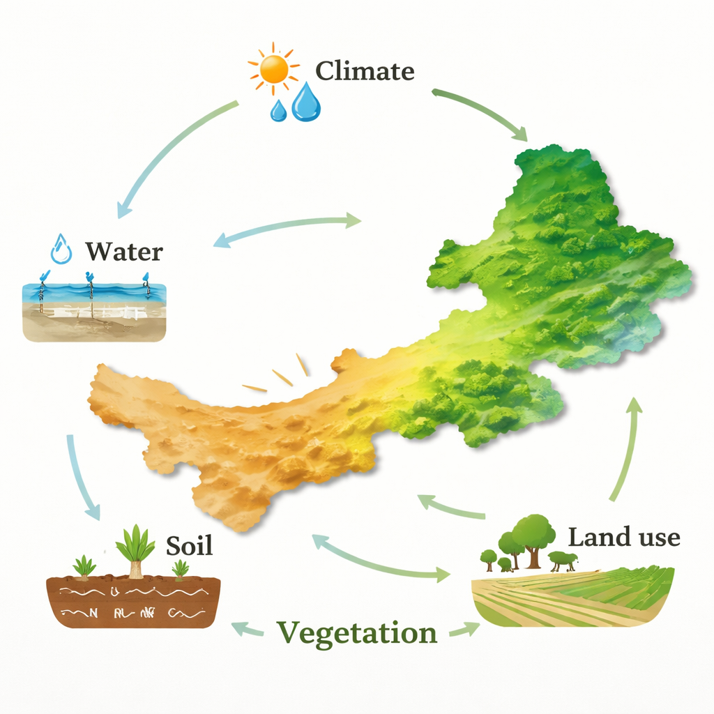
The quiet power of water and soil
To untangle what lies behind these patterns, the study compared vegetation changes with climate data, groundwater measurements, detailed soil surveys, and land‑use maps. Water emerged as the main lever. Groundwater depth showed the strongest link to yearly ups and downs in plant growth, even more than rainfall or temperature. Where the water table has fallen—often because of pumping, mining, or long dry spells—grasslands struggle to recover. At the same time, differences from place to place were shaped most by soil nutrients and terrain. Areas rich in total nitrogen and organic matter supported stronger vegetation, while land‑use practices such as grazing and farming further amplified or dampened these natural advantages.
What this means for protecting dryland ecosystems
Put simply, the study shows that Inner Mongolia’s vegetation has generally greened over the past quarter‑century, but this progress is fragile and uneven. A sophisticated satellite index, kNDVI, reveals early warning signs of decline in dry western areas that might look stable under older methods. The findings point to a clear message for land managers and policymakers: successful restoration in drylands cannot rely on planting trees or waiting for more rain alone. It must protect and manage groundwater, improve soil quality, and balance grazing and farming with the land’s limits. With these pieces in place, tools like kNDVI can help track whether vast steppe and desert regions are truly recovering—or quietly slipping toward irreversible degradation.
Citation: Dong, F., Qin, F., Zhang, T. et al. kNDVI reveals vegetation dynamics and hydro–edaphic controls in inner Mongolia (2000–2024). Sci Rep 16, 5244 (2026). https://doi.org/10.1038/s41598-026-35762-5
Keywords: dryland vegetation, Inner Mongolia, groundwater, remote sensing, ecosystem restoration