Clear Sky Science · en
Impact of the war on forest ecosystem in Ukraine based on Sentinel-2 data
Why war and woods belong in the same story
When we think about war, we picture ruined cities and displaced people, not damaged woodlands. Yet forests quietly clean the air, store carbon, protect soil and water, and offer shelter to wildlife and people alike. This study shows how the war in Ukraine is reshaping the country’s forests, using satellite images and artificial intelligence to reveal losses that would be too dangerous or difficult to measure on the ground.
Forests under pressure in a time of conflict
Ukraine’s forests were already under strain from logging and land-use change before the full-scale invasion began in 2022. Trees help regulate climate, support local economies, and improve urban life, but they are also a source of timber, fuel, and land for farming. When conflict erupts, normal safeguards weaken: protected areas may no longer be patrolled, and vast regions become too dangerous to visit because of shelling and unexploded ordnance. In Ukraine, roughly a third of the country has been affected in this way, making traditional field surveys of damage nearly impossible and pushing scientists to rely on satellites instead.
Watching forests from space
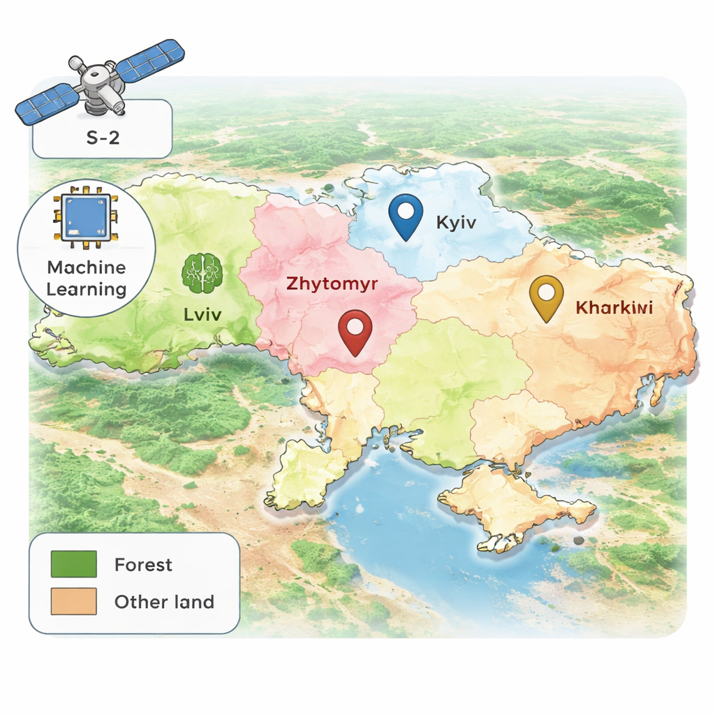
To track what was happening to the woods, the researchers turned to Sentinel-2, a pair of European satellites that capture high-resolution color and infrared images of Earth’s surface. These images can distinguish forests from fields and even tell apart broadleaf and coniferous trees. Using a machine-learning method called Random Forest, the team first created a detailed map of where forests were in 2020, just before the escalation of the war. They focused on four regions with substantial tree cover and heavy fighting: Lviv in the west, and Kyiv, Zhytomyr, and Kharkiv in the north and east. The computer model was trained with existing global land-cover maps, then carefully checked and refined using the satellites’ own light signatures to reduce errors.
Measuring what was lost
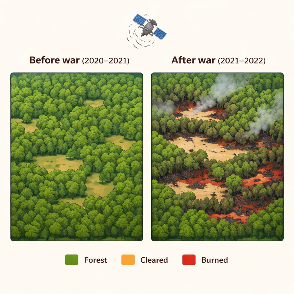
Once they knew where the forests were, the scientists examined how those areas changed between 2020 and 2022. Instead of simply comparing two maps, they analyzed seasonal “mosaics” of images from each summer and calculated how standard vegetation and burn indices shifted from year to year. These indices act like health scores for plants and are sensitive to both logging and fire. A second Random Forest model then sorted each forest pixel into three categories: unchanged, converted from woody to non-woody cover (such as clear-cuts or severe damage), or burned. To avoid counting tiny, uncertain changes, they discarded patches smaller than four pixels. Independent checks against fresh satellite images and online maps showed that the method was highly accurate, especially for mapping where forests still stood.
The war’s fingerprint on Ukraine’s forests
The numbers that emerged tell a stark story. Across the four regions, total forest loss reached about 51,700 hectares between 2020 and 2022, and the area lost in 2022 was more than double that in 2021. Before the war’s escalation, nearly three quarters of forest loss came from conversion to non-woody land, with fires accounting for about a quarter. Afterward, the balance shifted: while clearing and degradation still dominated, the share of burned forest rose to roughly one third of all loss. Kyiv and Kharkiv, which saw some of the most intense military activity, experienced the heaviest damage, both in absolute terms and as a fraction of their remaining woods. Coniferous forests, especially pine, were hit hard because they burn more easily than mixed or broadleaf stands, which helps explain why the Lviv region, with more broadleaf and mixed forests and less direct fighting, suffered fewer fire-related losses.
What this means for people and the planet
Beyond the immediate destruction of trees, the study points to deeper concerns. The doubling of forest converted to non-wood land suggests rising pressure for timber and land, likely driven by weakened institutions, illegal logging, and military infrastructure. Meanwhile, the researchers found that their locally trained satellite models captured more loss than widely used global products based on coarser imagery, particularly in war-torn areas where changes are patchy and complex. This matters because underestimating forest damage could mislead climate and conservation policies at a time when Ukraine’s ecosystems are already fragile. For non-specialists, the takeaway is sobering but clear: war does not only scar cities and lives; it also erodes the green systems that protect climate, water, and biodiversity. Reliable satellite monitoring can help authorities plan restoration, curb illegal cutting, and, in the long run, rebuild forests as part of both environmental recovery and a more stable peace.
Citation: Waśniewski, A., Rynkiewicz, A., Hościło, A. et al. Impact of the war on forest ecosystem in Ukraine based on Sentinel-2 data. Sci Rep 16, 5190 (2026). https://doi.org/10.1038/s41598-026-35744-7
Keywords: Ukraine war environment, forest loss, satellite monitoring, wildfire and logging, Sentinel-2