Clear Sky Science · en
Logging identification and prediction of diagenetic facies in the first member of Dainan formation, Southern Gaoyou Sag, Subei Basin, China
Why rock changes matter for our energy future
Deep beneath eastern China, ancient river deltas have left behind thick layers of sand and mud that now hold much of the region’s oil. But these rocks have been squeezed, cemented, and partially dissolved over tens of millions of years, turning once-loose sand into tight stone that does not easily let fluids flow. This study explores how those hidden changes in the rocks—known as “diagenesis”—control where oil can still move, and shows how modern downhole measurements can map the best zones for production without needing continuous physical cores from every well.
From lake delta sands to tight stone
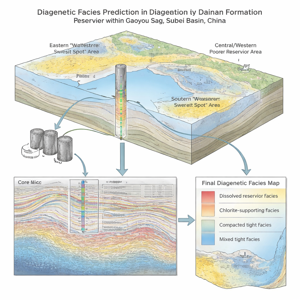
The work focuses on a key oil-bearing interval in the Dainan Formation within the Gaoyou Sag of the Subei Basin, one of the region’s most productive petroleum areas. During the Eocene, rivers delivered sand into a lake, building fan deltas that spread out across the basin floor. Over time, these sandy layers were buried to depths of 2.5 to 3.5 kilometers and transformed into sandstone. The researchers collected 45 samples from 25 wells across the sag, along with additional imaging and laboratory datasets, to build a detailed picture of what these rocks look like today and how they store fluids.
What the pores look like up close
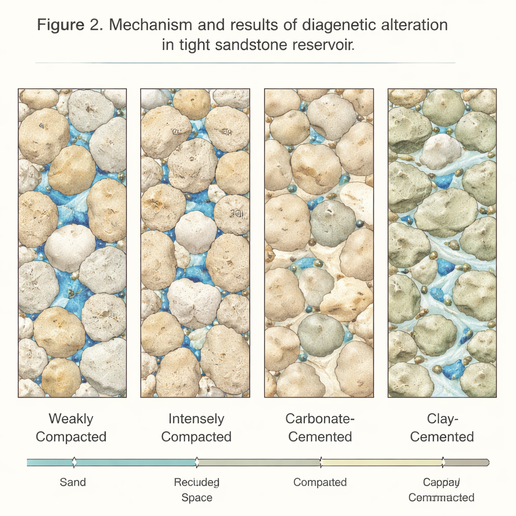
Under the microscope, most of the reservoir is a mixture of quartz, feldspar, and rock fragments—grains that once touched at a few points but are now squeezed together. Pore space takes several forms: original gaps between grains that survived burial, new pores etched into feldspar and other unstable fragments by chemically active fluids, tiny microfractures, and very small micropores. Nuclear magnetic resonance and mercury-injection tests show that the rocks typically have micrometer-scale pores connected by even narrower “throats,” explaining why many intervals are low in both porosity and permeability. Where dissolution has carved extra space into grains and connections between pores remain relatively open, the rocks can still act as decent reservoirs; where compaction and cement have dominated, flow is severely restricted.
Four flavors of rock quality
By combining mineralogy, pore images, and flow measurements, the team grouped the sandstones into four diagenetic “facies,” or rock types shaped by different histories. The most favorable type shows only weak compaction and modest clay growth, but strong dissolution of feldspar, producing comparatively large, well-connected pores and the best porosity and permeability. A second type has been intensely compacted but partially rescued by later dissolution, creating secondary pores within a tightly packed framework and yielding modest flow. The third type is heavily filled with carbonate minerals such as calcite, while the fourth is choked with clay minerals like illite; both of these have extremely poor connectivity and are essentially non-productive.
Reading rock history from well logs
Because direct core samples are sparse and expensive, the researchers asked whether simple electrical and acoustic measurements recorded in every well could stand in for laboratory analysis. They found that each facies produces a characteristic combination of gamma-ray (a proxy for clay content), acoustic travel time (sensitive to pore space and stiffness), and neutron response (affected by bound water in clays). For example, the best facies tends to show lower gamma-ray values but higher acoustic and neutron readings, while clay-heavy, poorly flowing rocks display uniformly high values on all three curves. Using these patterns, the team built cross-plots and templates that allow geoscientists to assign diagenetic facies continuously along a borehole, then tie those results to 3D seismic data to map facies across the entire field.
Turning rock types into better forecasts
Once every interval was labeled by its diagenetic facies, the authors developed separate mathematical relationships between acoustic logs and porosity for each facies. These tailored models match core measurements much better than a single, one-size-fits-all formula, especially in zones where dissolution has created extra storage space. When applied across the Gaoyou Sag, the workflow shows that the most promising, dissolution-rich facies cluster mainly in the eastern and southern fan-delta fronts, while the central and western sectors are dominated by cemented, low-quality rocks. In plain terms, the study provides a recipe for turning routine well logs and seismic surveys into detailed maps of “sweet spots,” helping operators target the limited parts of a tight reservoir where the rocks still have enough connected pore space to produce oil efficiently.
Citation: Li, Y., Liang, B., Xia, L. et al. Logging identification and prediction of diagenetic facies in the first member of Dainan formation, Southern Gaoyou Sag, Subei Basin, China. Sci Rep 16, 4898 (2026). https://doi.org/10.1038/s41598-026-35613-3
Keywords: tight sandstone reservoir, diagenetic facies, well log interpretation, pore structure, Gaoyou Sag