Clear Sky Science · en
Computation of topological relations with 3-SRM
How shapes on a map tell hidden stories
Every digital map, from a city planning tool to your phone’s navigation app, is built from simple shapes: regions that touch, overlap, or sit inside one another. Traditionally, computers have described how two regions relate—say, where a river meets a lake. But real-world scenes usually involve three or more regions at once: a city inside a district inside a state, or a wildlife reserve sitting between two expanding suburbs. This paper introduces a new way for computers to understand those richer, three-object patterns.
From pairwise links to whole scenes
For decades, geographic information systems have relied on “binary” models that look at pairs of regions at a time. Well-known examples, with names like the 9-Intersection Model and Region Connection Calculus, classify relations such as disjoint, meet, contain, and overlap between two areas. These approaches are powerful but limited: knowing all pairwise relations in a scene does not always tell you the full story. Three countries might each border the other two, or one might lie between the other two, yet the pairwise descriptions look similar. The authors show that such higher-level structure simply cannot be reconstructed from pairwise rules alone.
A new model for triples of regions
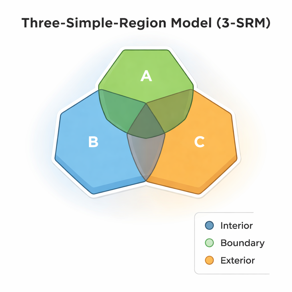
To overcome this, the authors propose the Three-Simple-Region Model (3-SRM), a framework that treats three regions as a single configuration. Each region is split into three basic parts—the interior, the boundary, and the exterior. Instead of comparing just two regions, 3-SRM looks at all possible triple intersections of these parts, effectively carving space into 27 small “cells.” By recording which of these cells are empty and which are not, the model can classify how the three regions relate in a much more detailed way while preserving the intuitive meanings of inside, outside, and touching inherited from earlier theories.
Sixteen ways three regions can relate
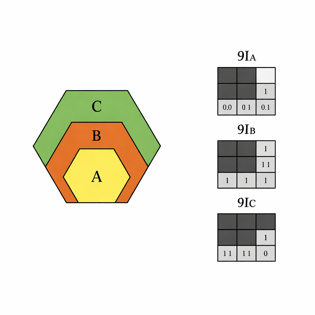
Out of all the possible intersection patterns, the authors identify 16 distinct kinds of three-region topological relations. Some are familiar extensions of the two-region world: all three might be disjoint, mutually overlapping, equal, or nested as contain and inside. Others are genuinely new and inherently triadic, such as between and in-between (where one region lies spatially between the other two), inner and outer (distinguishing central regions from surrounding ones), and more subtle cases like meet-inside, inside-meet, exterior meet, and boundary–exterior meet, which describe different ways boundaries and exteriors can touch. These relations are encoded using three compact 3×3 binary matrices, one for each region, making them suitable for efficient computation.
From abstract math to working software
The paper moves beyond theory by implementing a robust 3-SRM tool inside the open-source QGIS platform. The authors address messy realities of geographic data: invalid polygons, inconsistent map projections, tiny slivers, and naming inconsistencies between datasets. They use careful geometry repair, standardized coordinate systems, and conservative numerical thresholds so that intersections reflect meaningful area, not rounding noise. The software automatically builds the three 9-intersection-style matrices for any chosen trio of regions and then matches the pattern against a library of the 16 named relations, producing human-readable labels such as disjoint, covered-by, or boundary–exterior meet.
Testing on real administrative boundaries
To check that the model works outside of idealized diagrams, the authors test it on official Indian administrative boundaries—states, districts, and taluks—where the true containment and adjacency relationships are known. For a representative sample of 450 cases, the 3-SRM classifications match the government-defined hierarchy perfectly. The examples include simple disjoint states, nested units (taluks inside districts inside states), and more intricate arrangements where an area lies between others or shares only boundaries. The authors also discuss current limitations: the method assumes simple regions without holes or fractal-like boundaries, and more work is needed to handle such complex shapes.
Why this matters for maps and beyond
In simple terms, this research gives computers a more human-like grasp of how three areas in space relate at once, rather than only in pairs. That richer understanding can improve spatial queries in databases, help planners reason about overlapping jurisdictions, and support applications in robotics, cognitive science, and language technologies that rely on concepts like “between” or “surrounded by.” While the present work focuses on simple regions in flat maps, it lays a clear, mathematically grounded foundation for future models that can cope with more intricate geometries and real-world data.
Citation: Totad, N.P., Sajjanshettar, G.M. & Aithal, P.K. Computation of topological relations with 3-SRM. Sci Rep 16, 6059 (2026). https://doi.org/10.1038/s41598-026-35579-2
Keywords: qualitative spatial reasoning, topological relations, geographic information systems, spatial databases, region connection calculus