Clear Sky Science · en
Delineation of palaeochannels using DEM and spectral indices in the Gundar basin of Kadaladi region
Hidden Rivers Beneath Dry Ground
In many dry coastal regions, people depend almost entirely on underground water to drink, cook, and grow food. Yet we rarely see how that water moves below our feet. This study peels back the surface of southern India’s Kadaladi region to reveal buried traces of ancient rivers—"palaeochannels"—and shows how these hidden pathways could guide communities to fresher, more reliable groundwater without digging blindly or building costly desalination plants.
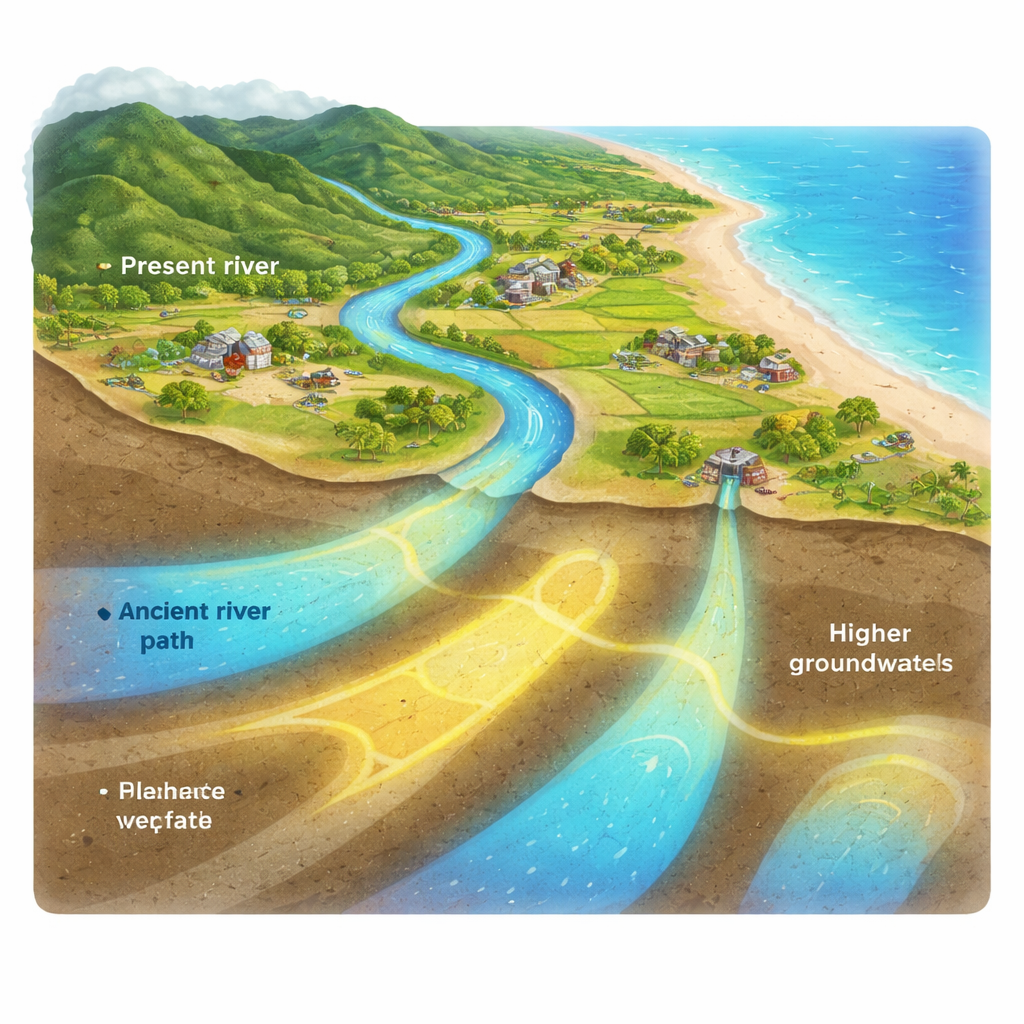
Ancient Riverbeds as Natural Water Tanks
Long before today’s farms and villages appeared, rivers in the Gundar Basin wandered across a broad, nearly flat coastal plain before reaching the Bay of Bengal. Over thousands of years, some of these channels shifted course or dried up, leaving their old paths buried under younger sediments. Because these old riverbeds are often filled with sand and gravel, they can act like natural underground tanks, storing and moving water more easily than the surrounding clays and rock. If mapped correctly, these palaeochannels can point to zones where wells are more likely to yield better-quality water, even in areas now plagued by falling water tables and increasing salinity.
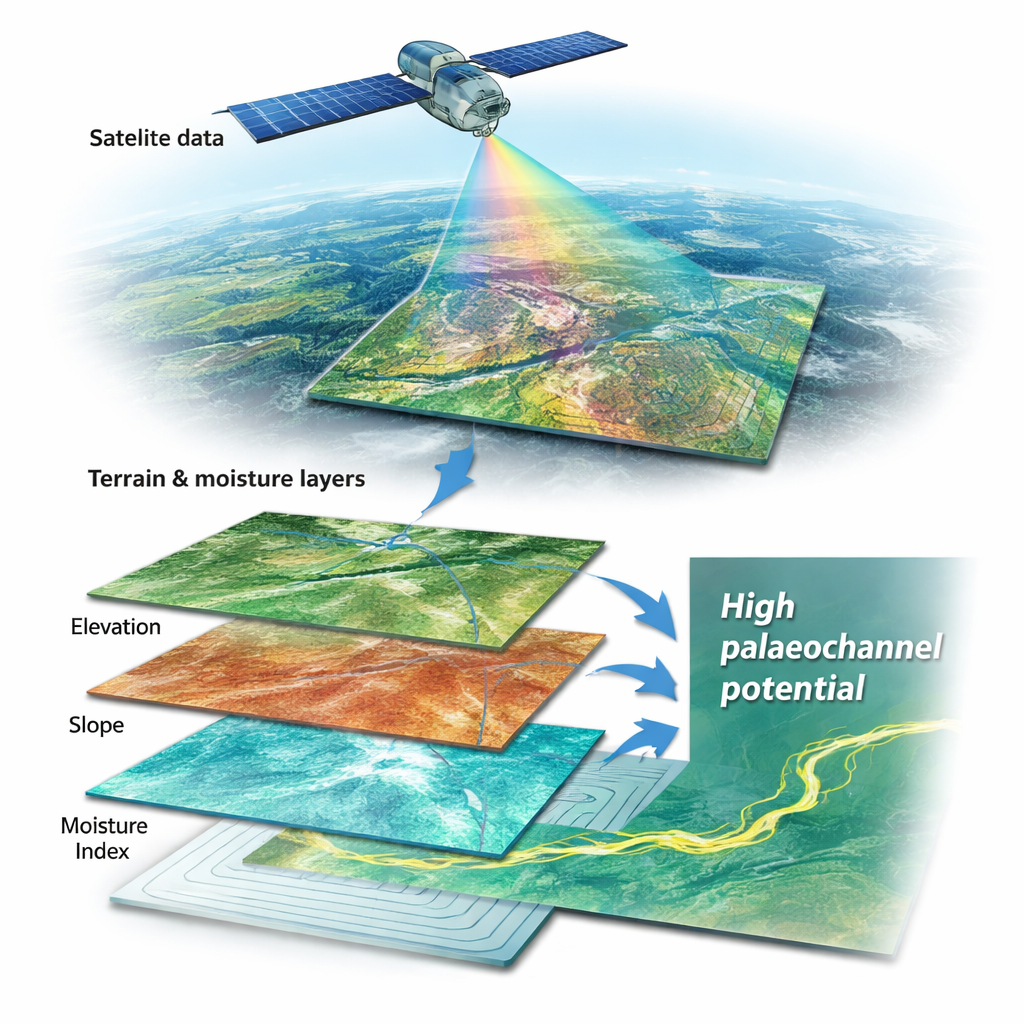
Reading the Landscape from Space
Instead of relying on expensive drilling or geophysical surveys, the researchers used freely available satellite images and digital elevation models to "read" subtle clues in the landscape. They combined Landsat 9 imagery, which records how land, vegetation, and moisture reflect light, with a detailed digital map of ground elevation from the ASTER mission. From these data they calculated simple indicators of plant health, surface water, and soil moisture, as well as how steep or flat the land is, how water would naturally flow downhill, and where it would tend to pool or linger. Although each map on its own is noisy and imperfect, together they highlight low-lying, gently sloping, moisture-rich strips that may trace the footprints of long-vanished rivers.
Blending Many Clues into One Picture
To turn this stack of maps into a clear picture of where palaeochannels are most likely, the team used a "fuzzy" overlay method. Rather than labelling any spot as simply "channel" or "not channel," they gave every location a score between 0 and 1 describing how well it matched the expected conditions of a buried riverbed: very gentle slopes, bowl-shaped ground, high potential for water to gather, and consistently moist soils that support healthy vegetation. These scores were then blended using a mathematical rule that balances optimistic and cautious views of the data. The end result is a probability-style map showing where the evidence from terrain, water, and vegetation all point toward the same conclusion: a hidden channel is likely below.
Where the Hidden Water Paths Lie
The final map suggests that about 18 percent of the Gundar Basin—mainly in its central and southeastern parts—has a high chance of containing palaeochannels. These areas form sinuous belts running roughly northwest to southeast, in line with the natural fall of the land and the present drainage towards the sea. They are marked by very low slopes, concave depressions, and consistently high moisture indicators, even though the climate is semi-arid and the surface often appears dry. Farmers already use some of these strips as productive fields, hinting that the subsurface really does hold more accessible water. While the study could not confirm the channels with field instruments, its patterns closely resemble those found in other parts of India where drilling and geophysical tests have been done.
What This Means for Water-Scarce Communities
For a layperson, the message is straightforward: in places like Kadaladi, where wells are deepening and seawater is creeping inland, the ghost paths of ancient rivers may be among the best spots to look for cleaner, more sustainable groundwater. By using satellite images and computer models, this work offers a low-cost, non-invasive way to narrow down where to drill new wells or place recharge structures, long before any equipment goes into the field. With future ground checks to confirm and refine the maps, the approach could help guide water planning across other stressed coastal regions, turning forgotten riverbeds into lifelines for present and future generations.
Citation: Narayanan, M.S.S., Pitchaimani, V.S., Sivakumar, M. et al. Delineation of palaeochannels using DEM and spectral indices in the Gundar basin of Kadaladi region. Sci Rep 16, 5050 (2026). https://doi.org/10.1038/s41598-026-35549-8
Keywords: groundwater, palaeochannels, remote sensing, coastal aquifers, Tamil Nadu