Clear Sky Science · en
Near future projections of tropical cyclone tracks over the Bay of Bengal using high resolution CMIP6 models
Why future storm paths matter to millions
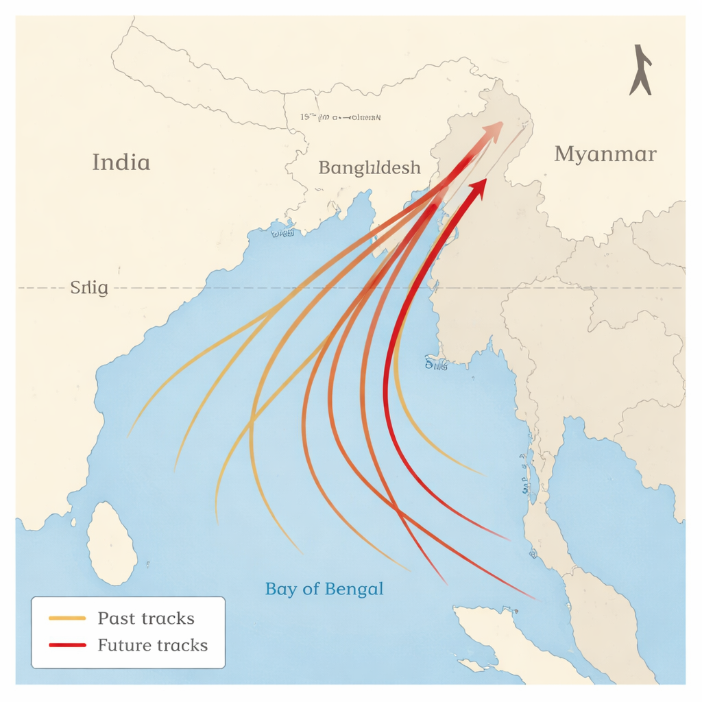
Tropical cyclones in the Bay of Bengal are among the deadliest storms on Earth, striking densely populated coasts in India, Bangladesh, Myanmar and Sri Lanka. Where these storms go – their tracks – can mean the difference between a close call and a disaster. This study asks a timely question: as the climate warms over the next few decades, will these storms keep heading mainly toward India’s east coast, or will their paths shift toward the far north of the bay, closer to low-lying delta regions?
Looking ahead with sharper climate models
To peer into the near future, the researchers turned to some of the world’s highest-resolution climate models, part of an international effort known as CMIP6 HighResMIP. These models divide the atmosphere and oceans into much finer grid boxes than older generations, allowing them to capture the structure and behavior of cyclones more realistically. The team first checked how well 14 such models could reproduce observed cyclone tracks over the north Indian Ocean between 1979 and 2014, focusing on the busy post-monsoon season from October to December. Using a suite of statistical tests, they found that only three models consistently matched where storms form and how they travel across the Bay of Bengal.
From past tracks to future pathways
Armed with the three best-performing models, the scientists compared a historical period (1979–2014) with a near-future period (2015–2050) under a high-emissions scenario. They were less concerned with how many storms form – which previous work suggests may change only modestly here – and more with where those storms go. The multi-model average points to a clear pattern: cyclone tracks over the Bay of Bengal shift northward. Fewer storms are projected to curve west-northwest toward India’s east coast, and more are expected to head north or northeast toward Bangladesh, Myanmar and the northern fringes of India. This poleward shift appears even though the overall number of storms in the bay changes very little.
Winds aloft take the wheel
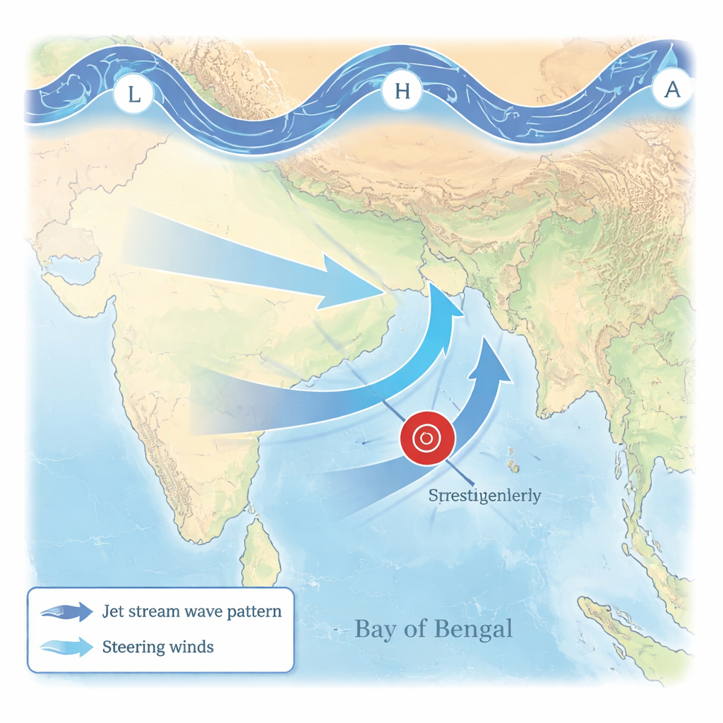
What causes this shift in pathways? One obvious suspect is where storms are born: if genesis zones move north, tracks might simply follow. But the models show only small and mostly insignificant changes in the average birthplace of cyclones. Instead, the crucial change occurs higher up in the atmosphere, around 10–12 kilometers above the surface. In these upper layers, the simulations project stronger westerly winds over the western and central Bay of Bengal and enhanced southerly winds over the north of the bay. Together, these changes form a broad cyclonic circulation over the Indian subcontinent that nudges storms away from their traditional westward path and steers them more toward the north.
Ripples from distant regions
The story does not stop over the bay itself. The models reveal that the altered steering winds are part of a larger wave pattern riding along the subtropical jet stream – a fast ribbon of air that circles the globe. This wave train appears to originate near the western Mediterranean and propagate eastward across Eurasia, creating alternating zones of swirling winds along its path. Over South Asia, this pattern favors a cyclonic circulation aloft that acts like a traffic sign redirecting storms toward higher latitudes. Other factors that often influence cyclones, such as sea surface temperatures, vertical wind shear and the rate at which temperature decreases with height, do not show a north–south contrast strong enough to explain the track changes. That strengthens the case that shifts in large-scale atmospheric waves and jet stream behavior are the main drivers.
What this means for people on the coast
For communities around the Bay of Bengal, a poleward shift in cyclone tracks could reshape where the greatest risks lie. Low-lying regions around Bangladesh and the northeastern Indian coast, already highly vulnerable to storm surge and flooding, may see a higher share of landfalling storms, while some areas farther south might experience fewer direct hits. The authors caution that these projections are based on a limited set of high-resolution models and on a high-emissions scenario ending in 2050, so there is still uncertainty. Even so, the consistent signal across the best models suggests planners and disaster managers should prepare for the possibility that, in a warming world, more of the bay’s cyclones will curve northward toward some of the most densely populated and fragile coastlines on the planet.
Citation: Adsul, R., Singh, V.K., Parekh, A. et al. Near future projections of tropical cyclone tracks over the Bay of Bengal using high resolution CMIP6 models. Sci Rep 16, 5567 (2026). https://doi.org/10.1038/s41598-026-35482-w
Keywords: tropical cyclones, Bay of Bengal, storm tracks, climate change, future projections