Clear Sky Science · en
Development of a stream DTM generation methodology using UAV-based SfM and LiDAR point cloud
Why mapping river bottoms matters
Rivers do far more than carry water. Their channels, sandbars and banks control floods, create wildlife habitat and shape how pollution moves downstream. Yet getting a precise map of the riverbed and nearby land is surprisingly hard, especially in shallow, vegetation-filled streams where boats, sonar and people with survey poles struggle to reach. This study shows how low-flying drones, laser scanners and smart computer filters can team up to build detailed “bare-earth” maps of a Korean stream, offering a safer, faster and more complete view of the hidden shape of rivers.
New eyes in the sky over a complex stream
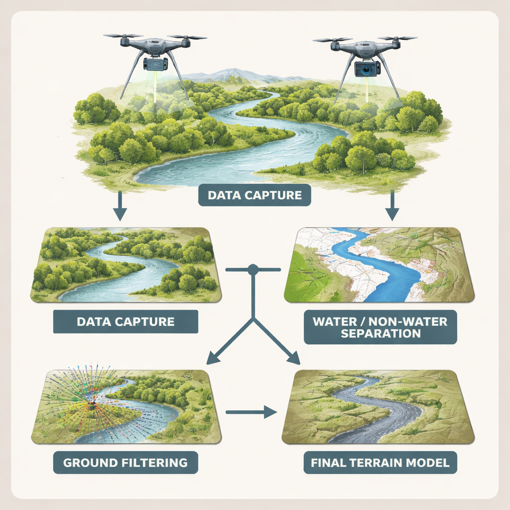
The researchers focused on a 2.8-kilometer stretch of the Bokha Stream in Icheon, South Korea, a landscape of winding channels, sandbanks, floodplains and tall riparian trees. Traditional surveys there would be slow, dangerous and unable to capture every twist and dip. Instead, the team used two kinds of drones. One carried a laser scanner (LiDAR) that sends out light pulses and measures how long they take to bounce back, producing a thick cloud of 3D points that can pierce through foliage to the ground. The other flew a multispectral camera and used a technique called structure from motion (SfM), stitching many overlapping photos into another 3D point cloud. Together, these complementary views offered dense coverage of both the vegetated banks and the shallow, mostly clear channel.
Separating water from land and ground from clutter
Raw 3D point clouds record everything: leaves, branches, buildings, noise in the air and reflections on rippling water. To model only the true terrain, these extra points must be stripped away. The team first distinguished water from land using a simple color-based indicator called the Normalized Difference Water Index, which compares how bright each pixel appears in the green and near‑infrared parts of the spectrum. Pixels with values above a chosen cutoff were tagged as water. In land areas, LiDAR points were favored because laser pulses can slip between leaves to the soil. In water areas, where LiDAR mostly reflects at the surface and “sees” no depth, the researchers relied instead on the photo-based SfM data, which can sometimes track features on the streambed through shallow, relatively clear water.
Putting three digital brooms to the test
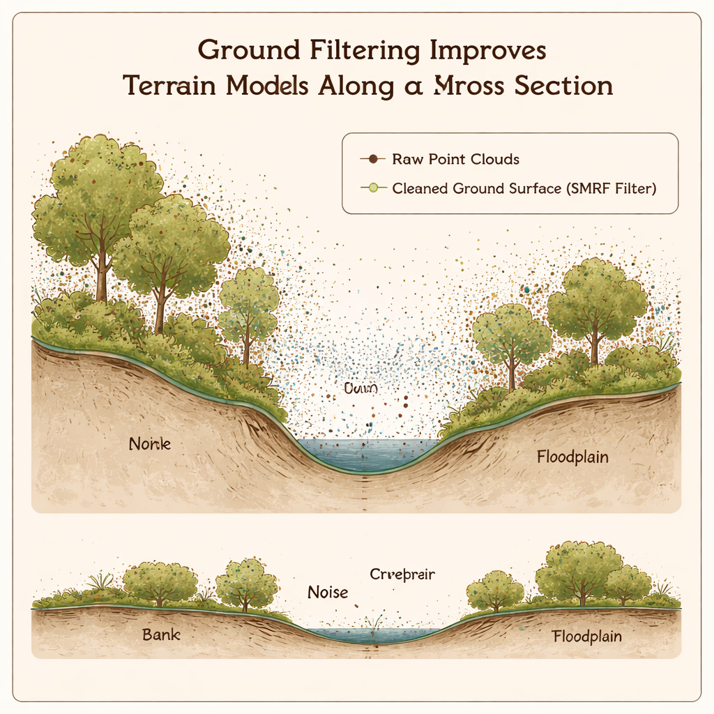
Next came the tougher step: scrubbing out vegetation and other non-ground objects while keeping the real shape of the banks and bed. The team compared three widely used “digital brooms,” or ground filters. The cloth simulation filter imagines a flexible sheet draped over an upside-down point cloud, treating the cloth as the ground. The progressive TIN filter gradually builds a mesh surface from low points, adding more if they fit height and slope rules. The simple morphological filter (SMRF) repeatedly erodes and expands the surface, trimming high objects like shrubs and trees. For each method the researchers tested many parameter settings, tuned for LiDAR on land and SfM in water, and then checked the resulting terrain against 11 carefully measured cross-sections taken with traditional surveying instruments.
Finding the best match to the real river
Accuracy was judged using the average and root-mean-square differences between the modeled and surveyed heights. When LiDAR and SfM were used separately, the photo-based method did better overall because it could partially capture the submerged bed that LiDAR missed. But the clearest picture emerged when the two datasets were combined: LiDAR for land, SfM for water, both cleaned by optimized filters. Among the three algorithms, SMRF gave the best overall performance, with errors on the order of only 16 to 21 centimeters across the full area. It excelled at removing dense shrubs and tall trees while preserving sharp features like small terraces and steep banks, which are crucial for realistic flood and habitat models, though it sometimes slightly underestimated heights in water zones.
What this means for rivers and their neighbors
In practical terms, the study delivers a tested recipe for turning messy drone measurements into accurate bare-earth maps of small, shallow streams. By automatically separating water from land and smartly blending laser and photo data, the method overcomes many of the blind spots of older boat- or ground-based surveys. The authors identify SMRF as the most reliable general-purpose filter for this kind of mixed river corridor, while noting that another method, the cloth simulation filter, is particularly steady in tricky water areas with bad points. Together, these insights can help engineers and ecologists build better flood models, plan restoration projects and track how rivers change over time, all with less field risk and cost. As greener laser systems and improved processing spread, this approach could make high‑resolution riverbed mapping a standard tool for managing waterways.
Citation: Gou, J., Lee, H., Park, J. et al. Development of a stream DTM generation methodology using UAV-based SfM and LiDAR point cloud. Sci Rep 16, 5178 (2026). https://doi.org/10.1038/s41598-026-35473-x
Keywords: river mapping, drone surveying, LiDAR, digital terrain model, stream ecology