Clear Sky Science · en
Automated satellite-based glacial lake inventory and change detection in High Mountain Asia
Why high mountain lakes matter to people downstream
High above the tree line in Asia’s great mountain ranges lie tens of thousands of small, cold lakes perched on or beside glaciers. These pools may look remote and pristine, but they quietly regulate the water flowing into some of the world’s major rivers—and can occasionally unleash devastating floods. This study shows how scientists used a new, fully automated method based on open satellite data to track nearly every glacial lake across High Mountain Asia and how these lakes are changing in a warming climate.
Watching water in the rooftop of the world
High Mountain Asia spans the Himalaya, Karakoram, Tien Shan and other ranges sometimes called Earth’s “Third Pole” because of their vast ice reserves. Snow and glacier melt from this region feeds the Indus, Ganges, Brahmaputra and many other rivers that support hundreds of millions of people. Glacial lakes act as natural reservoirs, storing meltwater and releasing it gradually downstream. Yet when their natural dams fail—because of a landslide, an ice avalanche or simple weakening over time—they can produce glacial lake outburst floods, or GLOFs, that race down narrow valleys and into settled areas. Nearly 700 such events have been documented in High Mountain Asia since the 1800s, causing thousands of deaths and major damage to roads, bridges and hydropower projects.
From hand-drawn maps to smart, automated eyes
Scientists have long used satellite images to map glacial lakes, but earlier work relied heavily on manual tracing or semi-automatic tools that still needed a human to fix mistakes. Mountain shadows, snow, floating ice and dark rock often tricked the software into confusing land with water or vice versa. As a result, many maps ignored the smallest lakes, even though these can also burst and cause serious floods. The new study tackles these challenges by combining several free satellite data streams—optical images from Landsat-8 and Sentinel-2, radar data from Sentinel-1, temperature information and a modern digital elevation model—on the Google Earth Engine cloud platform. 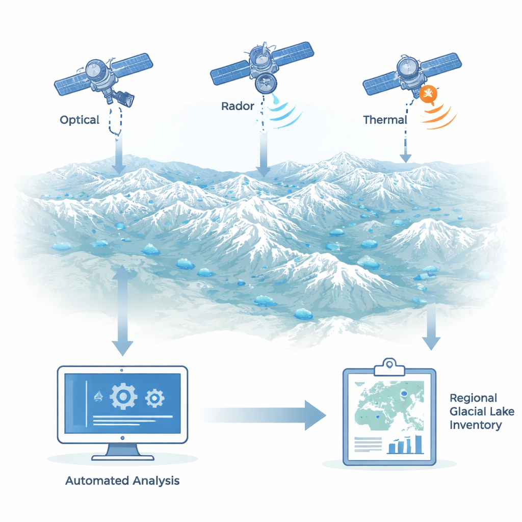
How the new digital lake finder works
The researchers first defined zones around more than 94,000 glaciers across 15 mountain subregions, extending 12.5 kilometers from each glacier to catch lakes formed by both present-day and past ice. They then filtered thousands of satellite scenes to focus on the ice-free season and built clever “composite” images that minimize clouds while preserving the largest likely extent of each lake. By blending different water-sensitive color indices from optical images with radar reflections, and masking out steep slopes and very cold surfaces, the system picked out pixels that behaved like open water. These candidate water patches were cleaned up using object-based rules and histogram tests to weed out shadows and other impostors. In a second step, high-resolution Sentinel-2 images were used to sharpen the lake outlines further, automatically choosing scenes where each lake looked largest and least snow covered. Finally, river-like shapes were stripped out using global river maps.
A detailed census of high mountain lakes
With this pipeline, the team produced a 2022 inventory of 31,698 glacial lakes across High Mountain Asia, covering about 2,240 square kilometers—roughly the area of a small country. Most lakes are small: over half are under 20,000 square meters, and only about one in ten exceeds 100,000 square meters, though these larger lakes hold more than 70 percent of the total water surface area. Nearly 70 percent of the lakes lie between 4,000 and 5,400 meters above sea level, with Inner Tibet hosting the highest lakes and East Tien Shan some of the lowest. When the researchers repeated their mapping for two multi-year periods, 2016–17 and 2022–24, and compared the results, they found that overall lake area grew by about 5.5 percent. Growth was uneven: Qilian Shan saw an increase of more than 22 percent, while Pamir barely changed. About three-quarters of lakes stayed roughly the same size, a small fraction shrank, and the rest expanded—especially those directly touching glacier fronts, which are strongly linked to ongoing glacier retreat.
How reliable is this automated picture?
To check how well the system worked, the authors compared its output to painstaking manual mapping in four test regions that span the main climate zones of High Mountain Asia. For medium and large lakes, the automated method detected more than 96 percent and 100 percent of lakes, respectively, and traced their outlines with an average area accuracy of around 97 percent. Performance dropped for the very smallest lakes, where limited image resolution and seasonal freezing make detection difficult, but the approach still outperformed other automated inventories and closely matched the best manual work. 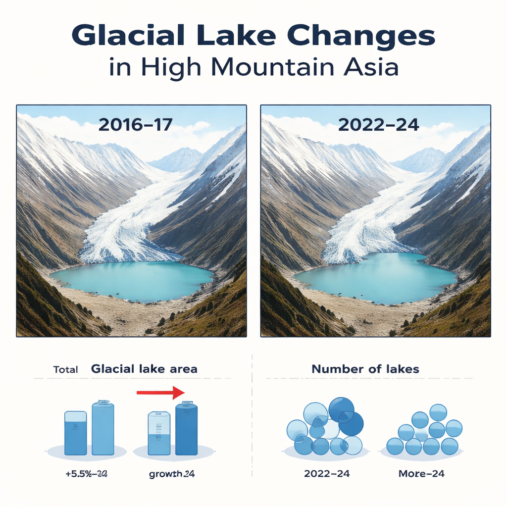
What this means for people living below
The study shows that it is now possible to keep an up-to-date, nearly wall-to-wall watch on glacial lakes across one of the world’s most remote and rugged regions without relying on armies of analysts. The new inventory confirms that these lakes are increasing in number and size as glaciers thin and retreat, raising concerns about future outburst floods but also clarifying where water storage is growing most rapidly. By making their maps and methods openly available, the authors provide a solid baseline that agencies can use to prioritize detailed field checks, design early warning systems and plan infrastructure with future lake changes in mind. As satellites continue to improve, this kind of automated monitoring could even move toward yearly or seasonal updates, giving communities more time to prepare for both the risks and the opportunities that come with a changing high-mountain water world.
Citation: Kumar, R., Vijay, S. Automated satellite-based glacial lake inventory and change detection in High Mountain Asia. Sci Rep 16, 5760 (2026). https://doi.org/10.1038/s41598-026-35446-0
Keywords: glacial lakes, High Mountain Asia, satellite monitoring, climate change, flood risk