Clear Sky Science · en
Near surface generation, burial recrystallization, and structural overprinting of carbonate platform dolomites
Why Rocks that Store Fluids Matter
Deep beneath the deserts of Saudi Arabia lie thick stacks of ancient limestones and dolomites that act as natural storage tanks for water, oil, gas and, increasingly, carbon dioxide. This study asks a deceptively simple question with big practical consequences: how did these rocks become dolomite, and how has their structure changed over time? By answering that, the authors can explain why some layers transmit fluids easily whereas others act as barriers—knowledge that underpins energy production, geothermal projects and carbon storage plans.
A Giant Shallow Sea Frozen in Stone
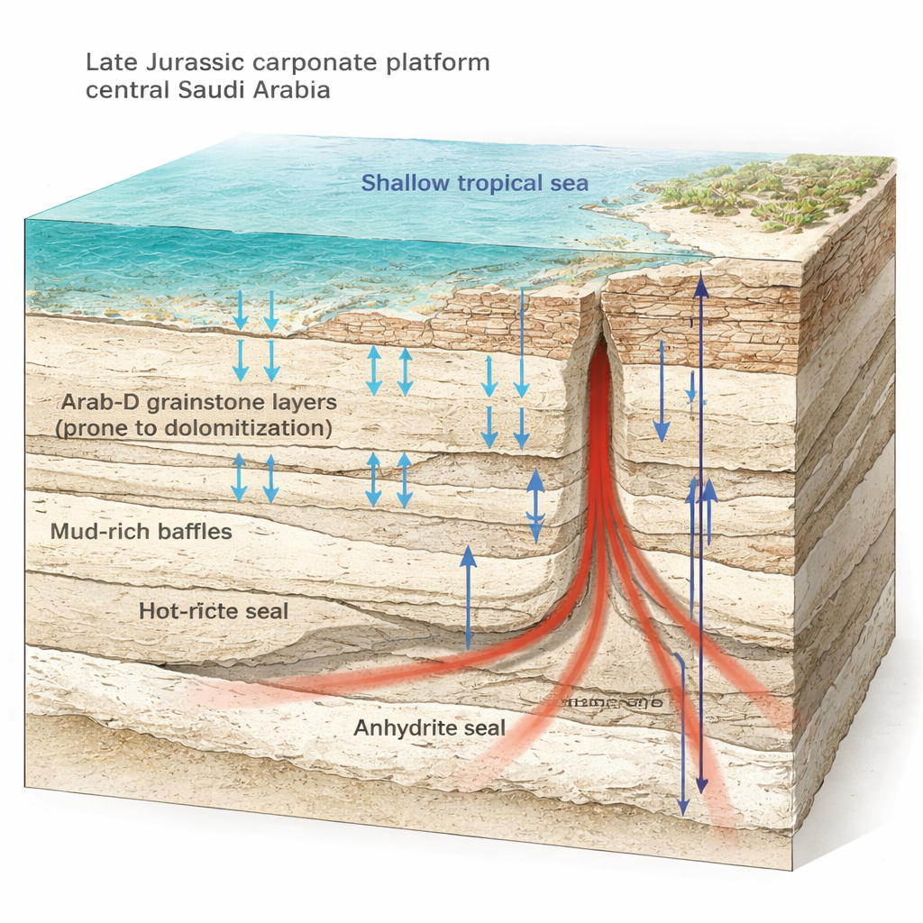
About 150 million years ago, the Arabian plate sat in the tropics and was covered by a broad, warm, shallow sea. On this wide shelf, waves and currents piled up sand-sized carbonate grains into porous layers, while quieter areas accumulated muddier sediments. These stacked layers form the Jubaila and Arab formations, which today are among the world’s most important hydrocarbon reservoirs. In central Saudi Arabia, erosion has cut spectacular cliffs through these rocks, exposing laterally continuous beds of unusually hard, resistant dolomite interlayered with softer limestone. The outcrops provide a rare, side-on view of the same types of rocks that, farther east, lie buried and produce enormous volumes of oil.
High-Tech Eyes on Cliff Faces
Traditional field mapping along steep desert cliffs is slow and subjective. To overcome this, the team used drones equipped with both normal cameras and hyperspectral sensors. Hyperspectral imaging breaks reflected sunlight into hundreds of narrow wavelengths, allowing the scientists to distinguish between minerals such as calcite and dolomite and even to infer differences in crystal texture. By draping these mineral maps onto high-resolution 3D models of the cliffs, they created a “hypercloud” that shows, at centimeter resolution, exactly where dolomite occurs, how thick the layers are, and how their textures vary over hundreds of meters. They then tied these images to drill cores and thin-section microscopy, and measured subtle isotope signals in the rock to reconstruct the temperatures and compositions of the fluids that altered it.
Layered Dolomite Built by Repeated Shallow Cycles
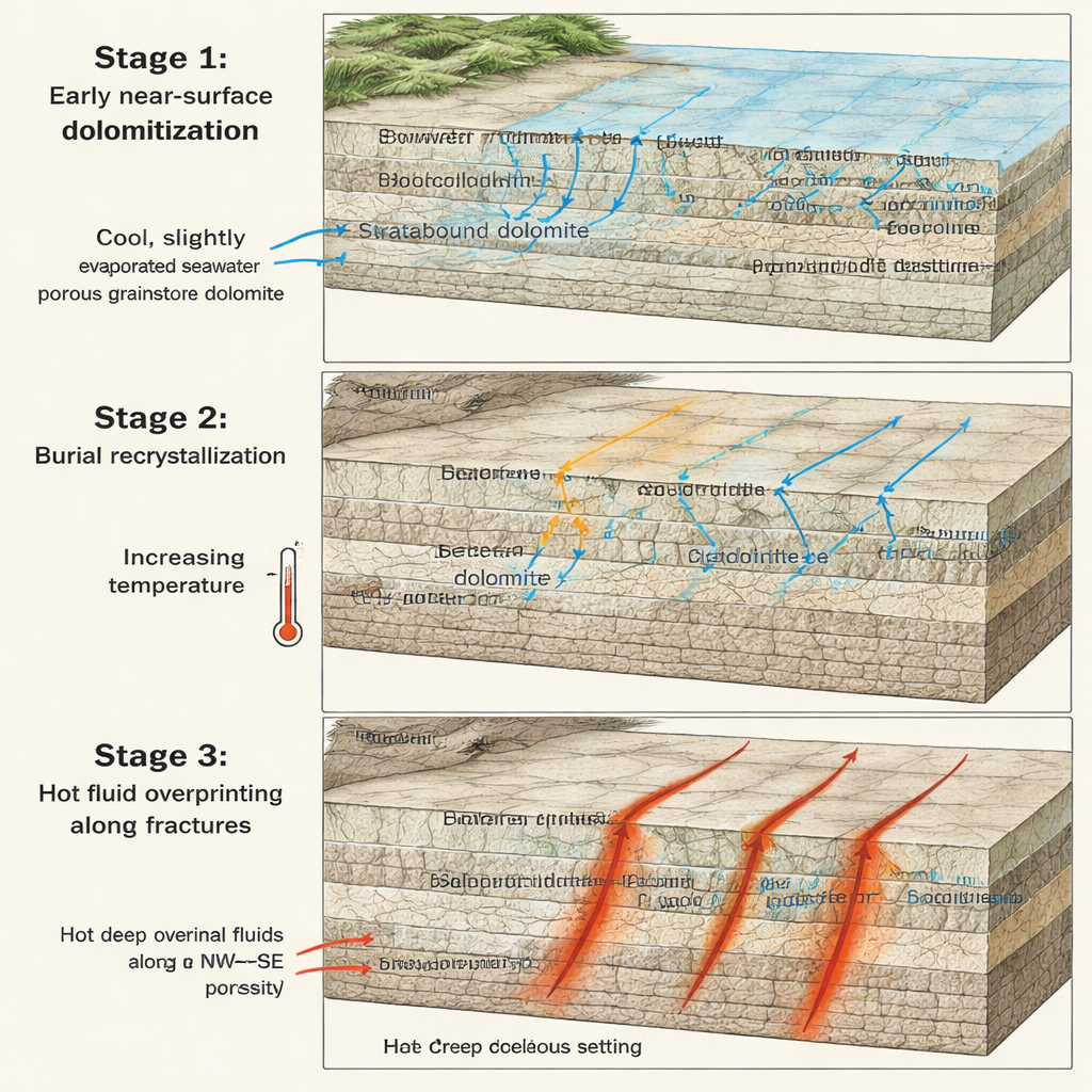
The analyses reveal that dolomite in the Arab-D member did not form in a single, late, basin-wide event, as commonly assumed. Instead, it developed repeatedly near the seafloor or just below it, at relatively cool temperatures around 30 °C from slightly evaporated seawater. Each time sea level shallowed, more porous, grainy layers acted as easy-flow pathways for magnesium-rich brines, turning them into laterally extensive, sheet-like dolomite beds. In contrast, thin mud-rich layers had low permeability and remained mostly limestone, only locally dolomitized in burrows. Stacking of many such high‑frequency cycles built an alternating pattern of dolomite and limestone—a natural architecture of flow conduits separated by baffles that already introduced strong contrasts in how fluids can move through the rock.
Burial Heat and Tectonic Cracks Rewrite the Rock
Dolomite, once formed, did not remain static. As the Arabian plate subsided and these rocks were buried to depths of roughly two kilometers, they warmed and interacted with evolving pore waters. Isotope measurements show that early, somewhat disordered dolomite crystals slowly reorganized into more stable forms, recording progressively higher temperatures and more saline fluids. The story did not end there: later, during a major tectonic episode in the Late Cretaceous, new fracture networks opened, especially along northwest–southeast trends. Hot, deeply sourced fluids rose along these cracks, then spread sideways within the already dolomitized layers. Where this hot fluid overprinted the earlier dolomite, the textures became coarser and partly leached, and porosity and permeability increased, particularly close to the fractures.
What This Means for Fluids in the Subsurface
By merging drone-based mineral maps, detailed microscopy, fracture analysis and isotope “thermometers,” the authors build a three-stage story: early near-surface dolomite grew in repeated cycles, that dolomite was then stabilized during burial, and finally hot fluids travelling along tectonic fractures reshaped the rock once more. For a lay reader, the key message is that these rocks are anything but uniform. Even within a single stratigraphic unit, there are laterally extensive dolomite sheets, thin muddy barriers, and fracture-linked sweet spots of very high flow. This intricate geometry helps explain why wells drilled into the same reservoir can behave so differently, and it offers a powerful template for predicting where the best fluid pathways—and the safest storage zones—are likely to be hidden underground.
Citation: Gairola, G.S., Thiele, S.T., Khanna, P. et al. Near surface generation, burial recrystallization, and structural overprinting of carbonate platform dolomites. Sci Rep 16, 5029 (2026). https://doi.org/10.1038/s41598-026-35353-4
Keywords: dolomite reservoirs, hyperspectral imaging, Arab-D formation, fracture-controlled flow, carbonate diagenesis