Clear Sky Science · en
Extrapolation of seismic land streamer data using interferometry
Seeing Deeper with Fewer Sensors
When engineers and environmental scientists want to peek beneath roads, building sites, or flood embankments, they often rely on seismic surveys—sending vibrations into the ground and recording the echoes. A newer, faster version of this approach uses a towed “land streamer” of sensors. It is efficient but struggles to see very deep. This paper presents a clever mathematical method that lets researchers squeeze more depth and detail out of the same land streamer data, without adding a single extra sensor or spending more time in the field. 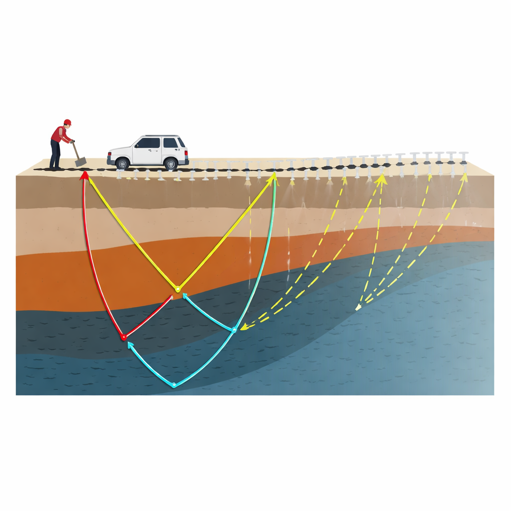
The Challenge of Quick Ground Scans
Land streamers are lines of geophones bolted onto small plates and dragged behind a vehicle. A simple source, such as a weight hitting the ground, sends vibrations into the subsurface, and the moving array records how long they take to return. Because this setup is mobile and easy to deploy, it is ideal for time-sensitive work like inspecting roads, assessing building foundations, or checking environmental sites. However, there is a catch: the streamer is short, and the sensors do not couple perfectly with the ground. As a result, recordings from distant sensors are weak and noisy, and typical surveys can only probe down a few tens of meters. Traditional fixes—like repeating the survey with shifted positions or using more gear—cost time and money and still may not fully solve the depth problem.
A Virtual Extension of the Sensor Line
The study introduces Land Streamer Extrapolated Supervirtual Interferometry (LS-ESVI), a technique that effectively makes the streamer behave as if it were much longer than it really is. Instead of installing more sensors, LS-ESVI reuses the travel times of seismic waves already recorded at nearby sensor pairs. By comparing (in effect, subtracting and adding) the arrival times between sensors, the method reconstructs what the signal would look like at positions beyond the physical end of the streamer. This "virtual" extension doubles the useful length of the survey, giving access to deeper parts of the subsurface while relying only on data from the original pass. 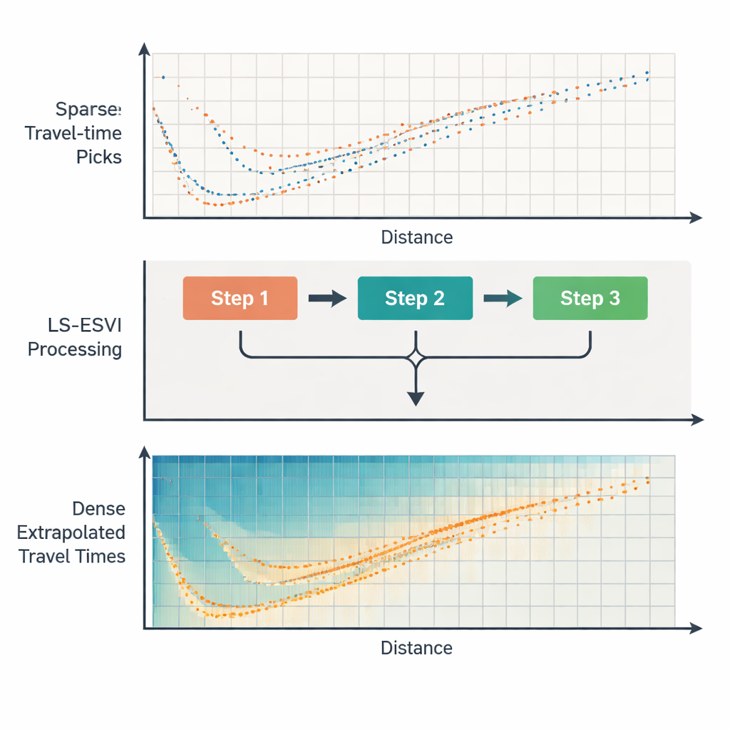
How the Method Works Behind the Scenes
At its core, LS-ESVI is built on interferometry, a branch of wave physics that shows how new wave paths can be synthesized by combining existing measurements. In the full theory this involves cross-correlation and convolution of entire waveforms, but the author simplifies it for practical use. Because many shallow surveys care mostly about the time of the first arriving wave, LS-ESVI operates on travel times rather than full signals. Conceptually, the method first estimates the extra time it takes for a wave to travel between two receivers through deeper, faster layers. It then adds this inter-receiver time to the known path from a source to one receiver, producing an estimated time to a “virtual” receiver located farther away. Optional clean-up steps—like deconvolution and an iterative enhancement procedure—can sharpen and strengthen weak signals, especially when the raw data are noisy.
Testing on Models and Real Ground
To judge whether these virtual arrivals are trustworthy, the author runs a series of tests. In computer-made models with two and three layers of rock, LS-ESVI uses only the near-offset travel times and then predicts the missing far-offset data. Because the full, ideal data set is also known, the two can be directly compared. In layered cases with uneven boundaries, the errors between extrapolated and true times are typically just a few thousandths of a second, well below what can be resolved by the seismic waves themselves. The method is also tested on a more challenging model where wave speed increases smoothly with depth; here, errors grow but still remain interpretable, highlighting both the potential and the limits of the approach. Finally, a field experiment near Dammam City in Saudi Arabia shows that for a real land streamer survey, 86% of the extrapolated arrivals differ from carefully picked reference times by less than 4 milliseconds—within the accepted resolution for this type of data. The extended data improve coverage for imaging methods that turn travel times into pictures of underground velocity.
Why This Matters for Everyday Projects
In simple terms, LS-ESVI lets researchers and practitioners “see further with what they already have.” Instead of bringing longer cables or repeating surveys, they can use smart processing to virtually double the reach of a land streamer. This means deeper and clearer images of the shallow subsurface for jobs like checking road stability, locating weak layers beneath buildings, or exploring for shallow resources—all with less disruption, cost, and time on site. While the method works best where underground layering is fairly regular and wave speeds do not change too abruptly, it offers a powerful new option whenever logistics limit how much equipment can be deployed on the ground.
Citation: Hanafy, S.M. Extrapolation of seismic land streamer data using interferometry. Sci Rep 16, 5531 (2026). https://doi.org/10.1038/s41598-026-35328-5
Keywords: seismic imaging, land streamer, interferometry, near-surface geophysics, traveltime tomography