Clear Sky Science · en
Attribute based access control of geographic spatial data sharing using blockchain and smart contracts
Why smarter map sharing matters
Every day, cities, emergency teams, and environmental agencies rely on digital maps and satellite images to decide where to build, how to respond to floods, or which forests need protection. Yet sharing this geographic data safely is surprisingly hard: the same map might be useful to scientists, utility companies, and first responders, but not everyone should see everything. This paper presents a new way to share such spatial data so that it is fast, secure, and auditable, even when many different organizations and users are involved.
The challenge of sharing sensitive maps
Geospatial information underpins urban planning, disaster response, and environmental monitoring, but current systems for controlling who can see what struggle to keep up. Traditional access rules tend to be either too simple—based only on a person’s job title—or too centralized, relying on a single powerful server that becomes a tempting target for attackers. As the number of users, data sets, and conditions grows, these older models become slow, hard to manage, and opaque. It becomes difficult to prove who accessed which data and whether rules were applied correctly, an issue that is especially serious when lives or critical infrastructure are at stake.
A new recipe: rules, chains, and code
To address these weaknesses, the authors combine three ideas. First, they use attribute-based access control, in which decisions depend on many details: a person’s role and clearance, the type and sensitivity of the data, the location and time of the request, and even network conditions. Second, they store access rules and activity logs on a private blockchain operated by trusted institutions such as government agencies and research centers. This shared ledger, maintained through a Proof-of-Authority process, makes records tamper-resistant and visible to all participants. Third, they implement the rules as smart contracts—small programs that automatically decide whether a request should be allowed—so that no single administrator has to be trusted to enforce policies correctly. 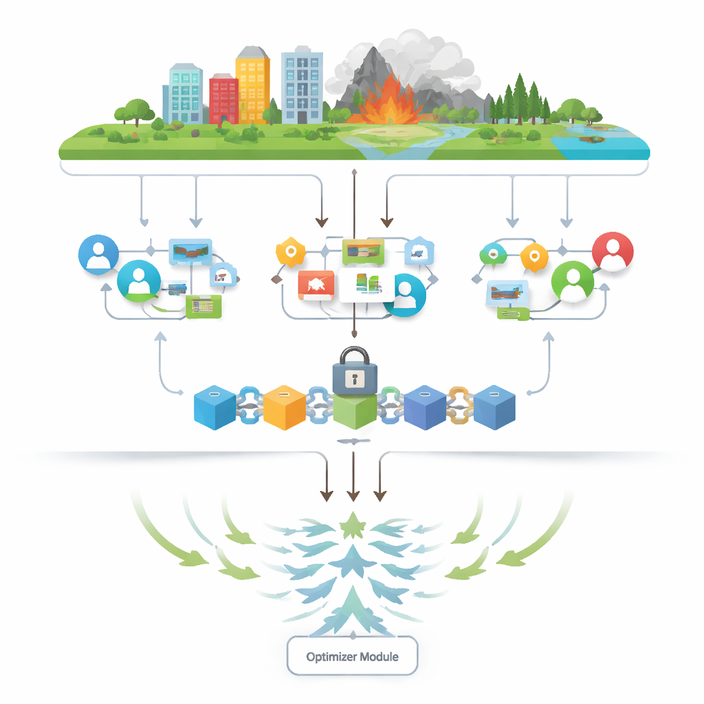
Letting a digital flock tune the rules
Highly detailed rules come with a cost: they can become tangled, redundant, and slow to evaluate. The paper’s distinctive contribution is an optimization method inspired by the hunting and migration behavior of a bird called the black-winged kite. In this metaphor, each candidate set of access rules is a bird exploring a landscape of possible solutions. The upgraded Black-winged Kite algorithm nudges these candidates toward better combinations, using mathematical versions of attack, migration, and random “mutations” to explore widely without getting stuck in poor local choices. Over many iterations, the algorithm finds leaner rule sets that still make correct decisions but require fewer checks and less storage.
How the full system works in practice
In the proposed architecture, administrators define fine-grained policies based on user, data, and environmental attributes. These policies are encoded into smart contracts and deployed on the private blockchain. When a user requests a dataset—say, a medium-sensitivity satellite layer for a particular region—their attributes and the dataset’s properties are fed into the smart contract, which checks the relevant rules and either grants or denies access. In the background, the bird-inspired optimizer periodically analyzes the full set of rules, removing overlaps, resolving contradictions, and simplifying the structure. Each access decision and policy update is written to the blockchain, creating a permanent, auditable trail of who accessed which maps and why. 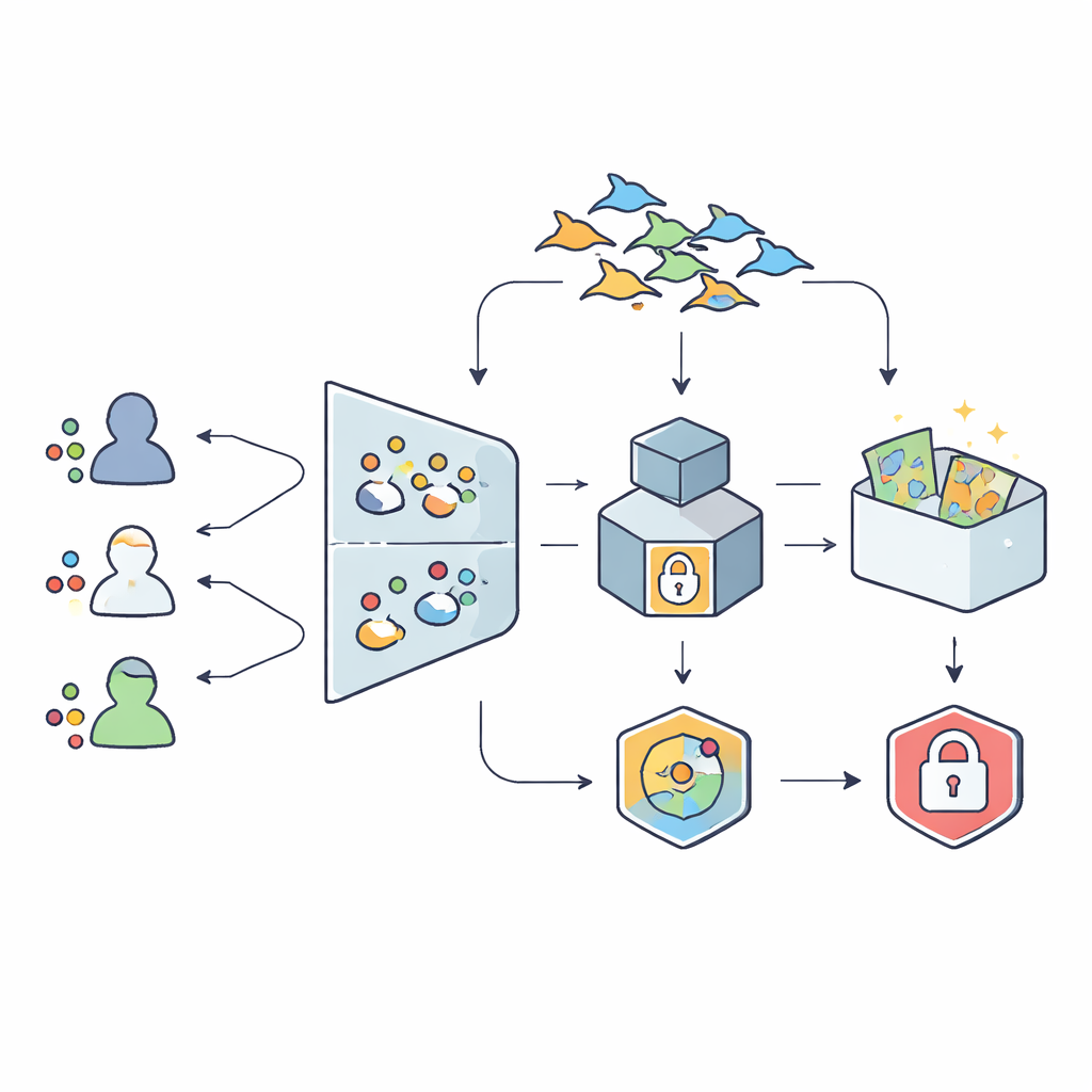
What the tests reveal
To test the framework, the authors built a simulated environment with 10,000 synthetic records representing different users and geographic datasets. They deployed a private blockchain network and compared their optimized system against both traditional attribute-based control and other well-known optimization techniques. The results are striking: evaluation time for access requests dropped by about 70 percent and storage needs by 52 percent compared with a non-optimized setup. The system still made correct decisions in 98.2 percent of cases, outperforming alternative optimization methods. Tests also showed that the time to evaluate policies and the storage used grows roughly in a straight line as the number of users, resources, and attributes increases, suggesting the approach can scale to large, real-world deployments.
What this means for real-world decisions
For a non-expert, the bottom line is that this framework offers a way to share sensitive map data among many partners without depending on a single gatekeeper. Detailed, context-aware rules decide who can see what, a shared ledger records every decision so it can be checked later, and a nature-inspired optimizer keeps the rulebook slim and efficient. Together, these elements make it more realistic for city planners, disaster responders, and environmental agencies to collaborate on rich spatial data while protecting privacy and security, turning complex digital maps into a safer common resource.
Citation: Li, S., Liu, W., Wu, Y. et al. Attribute based access control of geographic spatial data sharing using blockchain and smart contracts. Sci Rep 16, 9132 (2026). https://doi.org/10.1038/s41598-025-34703-y
Keywords: geospatial data sharing, access control, blockchain, smart contracts, optimization algorithm