Clear Sky Science · en
Spatial distribution of selected coastal Sabkhas along the Southern Red Sea Coast of Egypt
Salt Flats at the Edge of the Red Sea
Along Egypt’s southern Red Sea coast, vast pale plains shimmer between desert and sea. These are sabkhas—salt flats where seawater and groundwater rise close to the surface and then evaporate, leaving behind gleaming crusts of minerals. Far from being empty wastelands, sabkhas store clues about climate change, sea-level shifts, and how fragile coastal landscapes respond to both nature and development. This study shows how scientists used satellite data, maps, and fieldwork to decode how four of these unusual landscapes formed, how they are changing, and why they matter for Egypt’s future coastlines.
Desert Floors Made of Salt
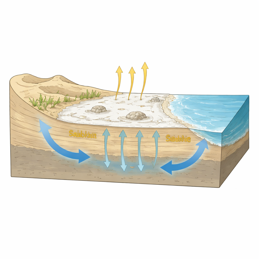
Sabkhas form in hot, dry regions where shallow salty water sits just below flat ground. When this water creeps upward through sand and mud and then evaporates, it leaves behind layers of salt minerals such as gypsum and halite. Over time, the surface becomes a hard crust dotted with polygon patterns, ripples, and small mounds, while the shallow subsurface alternates between wind-blown sand and tidally influenced mud. In winter, these flats can be flooded; in summer, they dry into crunchy layers of salt. The four sabkhas studied—Ras Baghdadi, Marsa Abu Madd, Bir Shalatein–Marsa Himeira, and the Diib alluvial fan—share this general pattern, but each is sculpted by a different mix of faults, rivers, dunes, and lagoons.
Seeing Salt from Space
To untangle these influences, the researchers combined decades of satellite images with digital elevation models and detailed visits on the ground. They used images from the Sentinel-2A satellite, which captures reflected light in many wavelengths, to build special “salinity indices” that highlight salty surfaces. Statistical tools compressed this information into sharp, color-contrasted views where sabkhas stand out from dunes, rocky hills, and mudflats. A digital elevation model mapped subtle changes in height and drainage paths from the Red Sea Mountains down to the coast. Field teams then walked the sites, logging boundaries with GPS, photographing features such as tepee-like buckles in the crust and microbial mats, and sampling sediments to confirm how salty they really were. Together, these steps produced high-resolution maps that show not just where sabkhas are, but how they are organized internally.
Four Salt Worlds, Four Different Stories
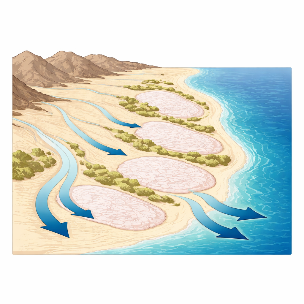
The mapping revealed that each sabkha represents a different “style” of coastal salt flat. At Ras Baghdadi, deep-seated faults create a structural low that traps both runoff from nearby wadis and seawater seeping landward, feeding an amoeba-shaped salt pond fringed by microbial mats that warp into tepee structures as salt crystals grow and gas accumulates. Marsa Abu Madd, by contrast, is closely tied to the sea: a chain of sand bars separates its flat, fine-grained plain from shallow lagoons, including a distinctive keyhole-shaped pond that is gradually becoming more cut off as sand builds up. Bir Shalatein–Marsa Himeira sits slightly higher and drier, behaving more like a desert playa, with circular and crescent salt patches and striking color zones from muddy blues and pinks to bright white salt bands and dark microbial spots. The Diib sabkha forms the seaward edge of a huge alluvial fan fed by floods from Sudan, where river-borne sediments, wind-blown sands, and occasional seawater together build a broad, flat, tepee-studded salt surface.
Changing Coastlines Over Fifty Years
By comparing satellite scenes from 1973 to 2023, the study tracked how these sabkhas have grown or shrunk. Overall, their combined area increased by about 12 percent, from roughly 126 to 142 square kilometers. Each site expanded, though at different rates: Ras Baghdadi by a modest fraction, Marsa Abu Madd and Bir Shalatein by a few square kilometers, and the Diib sabkha by more than eight. The authors argue that this broad expansion reflects rising sea level, which lifts the salty water table farther inland, together with intensifying aridity, which drives stronger evaporation and thicker salt crusts. Local factors modulate this trend—faults, sand bars, and flood-fed fans either trap or divert water and sediment—but the overall direction is toward more extensive salt flat conditions. Notably, the remote mapping and field observations showed little direct human disturbance within the sabkhas themselves, even as nearby coasts face rapid tourist and urban development.
Why These Salt Flats Matter
For non-specialists, these findings highlight that sabkhas are not barren edges of the desert but sensitive recorders of climate, sea level, and landscape change. Their growth along the southern Red Sea coast signals how a warming, drying world and a slowly rising sea are already reshaping shorelines. Because the study delivers detailed maps and a clear process-based model for how different types of sabkhas form—structural, lagoon-linked, desert-basin, and river-fed—its approach can guide coastal planning, conservation, and resource assessment in Egypt and in other arid regions. Protecting these salt flats means preserving natural archives of environmental history and buffering coastal ecosystems that will face increasing stress under future climate change.
Citation: Younis, N., El-Habaak, G.H., El Hadek, H.H. et al. Spatial distribution of selected coastal Sabkhas along the Southern Red Sea Coast of Egypt. Sci Rep 16, 8160 (2026). https://doi.org/10.1038/s41598-025-28627-w
Keywords: sabkha, Red Sea coast, salt flats, remote sensing, climate-driven coastal change