Clear Sky Science · en
Assessing the impact of groundwater abstraction and concrete dam fractures on saltwater intrusion using numerical modeling and interpretable machine learning
Why sea water can threaten our hidden water
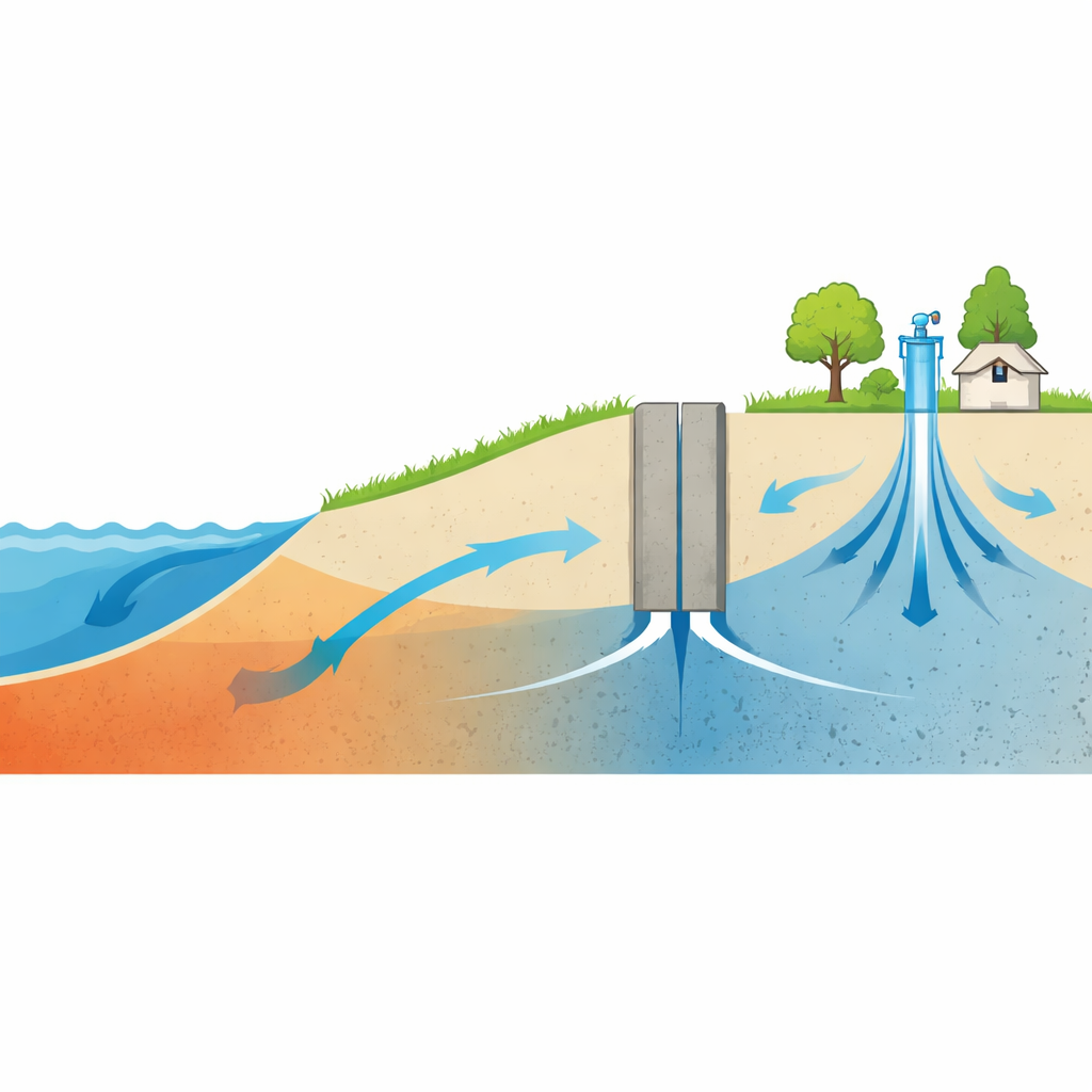
For many coastal communities, the most dependable drinking water does not come from rivers or reservoirs, but from underground layers of sand and gravel that store fresh groundwater. When too much water is pumped from these aquifers, or when protective structures fail, seawater can creep inland underground and turn fresh supplies salty. This article explores how that hidden saltwater front behaves when groundwater is pumped and when a concrete underground dam develops cracks, and shows how modern computer models and machine‑learning tools can help managers keep coastal aquifers safe.
The quiet advance of salty water underground
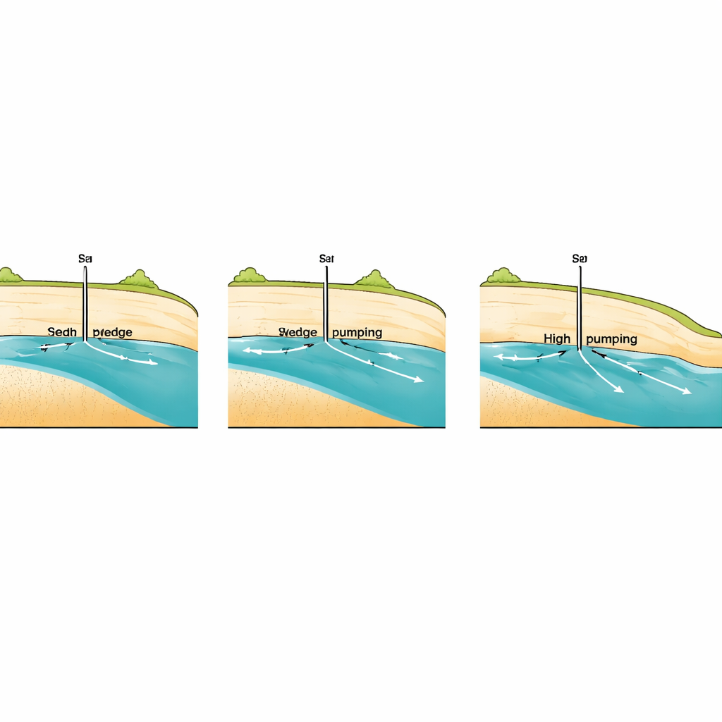
Along a coastline, fresh groundwater flowing toward the sea naturally pushes back a wedge of heavier saltwater. If pumping from wells increases or natural recharge declines, that balance is disturbed and the saltwater wedge can move inland, eventually reaching wells and irrigation intakes. Engineers sometimes build underground dams or cutoff walls below the surface to slow this advance, narrowing the path through which seawater can move. But in real life, these concrete barriers may crack or be built with deliberate openings, allowing some seawater to leak through. Understanding how the length of the saltwater wedge responds to pumping and to such fractures is vital, yet difficult to test directly in the field.
From detailed physics to smart shortcuts
The authors began with an existing set of 438 carefully designed computer simulations of a sloping coastal aquifer, created with a groundwater model that tracks both water flow and salt transport. In those simulations, they varied eight key factors, all expressed as simple ratios: the density contrast between fresh and salty water, the height and width of the fracture in the underground dam, the dam’s height and distance from the shore, the well’s depth and distance from the dam, and the pumping rate. For each scenario, the model produced the relative length of the saltwater wedge compared with aquifer depth, a compact measure of how far inland the seawater reached. This large synthetic data set served as the training ground for a suite of machine‑learning models.
Teaching machines to predict the salty wedge
Six different learning approaches were tested, ranging from straightforward linear regression to more flexible techniques such as decision trees, random forests, and an advanced method called extreme gradient boosting. Before training these models, the team checked the data for redundancy and statistical quirks, using standard tests to see which inputs had real influence and whether some moved together too closely. They then used an automated search strategy to fine‑tune each model’s internal settings and assessed performance with rigorous cross‑validation. The clear winner was the ensemble family of models, and especially the gradient‑boosting approach, which reproduced the simulated wedge lengths with errors small enough to be practically negligible.
Opening the black box of predictions
Accurate predictions alone are not enough for water managers, who also need to understand which levers matter most. To make the best‑performing model more transparent, the authors used tools that explain how each input nudges a given prediction up or down. These explanations showed that the rate at which water is pumped from the well is the dominant control on the wedge length: higher pumping draws the saltwater further inland. The height of the fracture in the dam came next, followed by its width and the distance between the well and the dam. Other factors, like the overall dam height or exact placement from the shore, still played roles but were less influential within the tested ranges. The team also confirmed that their model could match a separate set of detailed simulations for a real coastal aquifer in Cyprus, giving confidence that it can work beyond the original training cases.
Turning complex science into usable tools
To make these insights accessible, the authors wrapped the trained model in simple desktop and web interfaces. Instead of running heavy physics‑based simulations, a manager can now enter a handful of dimensionless ratios—representing well pumping, dam geometry, and fracture size—and instantly obtain an estimate of how far inland the saltwater wedge is likely to reach. In effect, the study shows that a carefully trained data‑driven model can stand in for much more demanding numerical calculations, while still reflecting the underlying physics.
What this means for coastal water users
The work demonstrates that the creeping inland march of seawater can be forecast quickly and reliably using machine learning trained on high‑quality simulations. For a layperson, the key message is simple: how hard we pump coastal groundwater and how well we design and maintain underground barriers have a direct impact on whether wells stay fresh or turn salty. By highlighting which design choices and operating conditions matter most, and by packaging that knowledge in easy‑to‑use software, this study offers a practical decision aid for protecting scarce fresh water in coastal regions under growing stress.
Citation: Armanuos, A.M., Zeleňáková, M. & Elshaarawy, M.K. Assessing the impact of groundwater abstraction and concrete dam fractures on saltwater intrusion using numerical modeling and interpretable machine learning. Sci Rep 16, 8940 (2026). https://doi.org/10.1038/s41598-025-27998-4
Keywords: saltwater intrusion, coastal aquifer, groundwater pumping, underground dam, machine learning