Clear Sky Science · en
A Global-Scale Time Series Dataset for Groundwater Studies within the Earth System
Why Hidden Water Matters to Everyday Life
Most of the fresh water that people and ecosystems rely on is hidden beneath our feet as groundwater. It keeps rivers flowing in dry seasons, supports crops and cities, and sustains wetlands and forests even when rain is scarce. Yet, compared with weather or river levels, we know surprisingly little about how groundwater behaves around the world, or how it is changing in response to climate shifts and human use. This article introduces a new global dataset called GROW that brings together hundreds of thousands of groundwater measurements and links them to other parts of the Earth system, making it far easier for scientists and planners to study these hidden water reserves.
A New Global Window into Underground Water
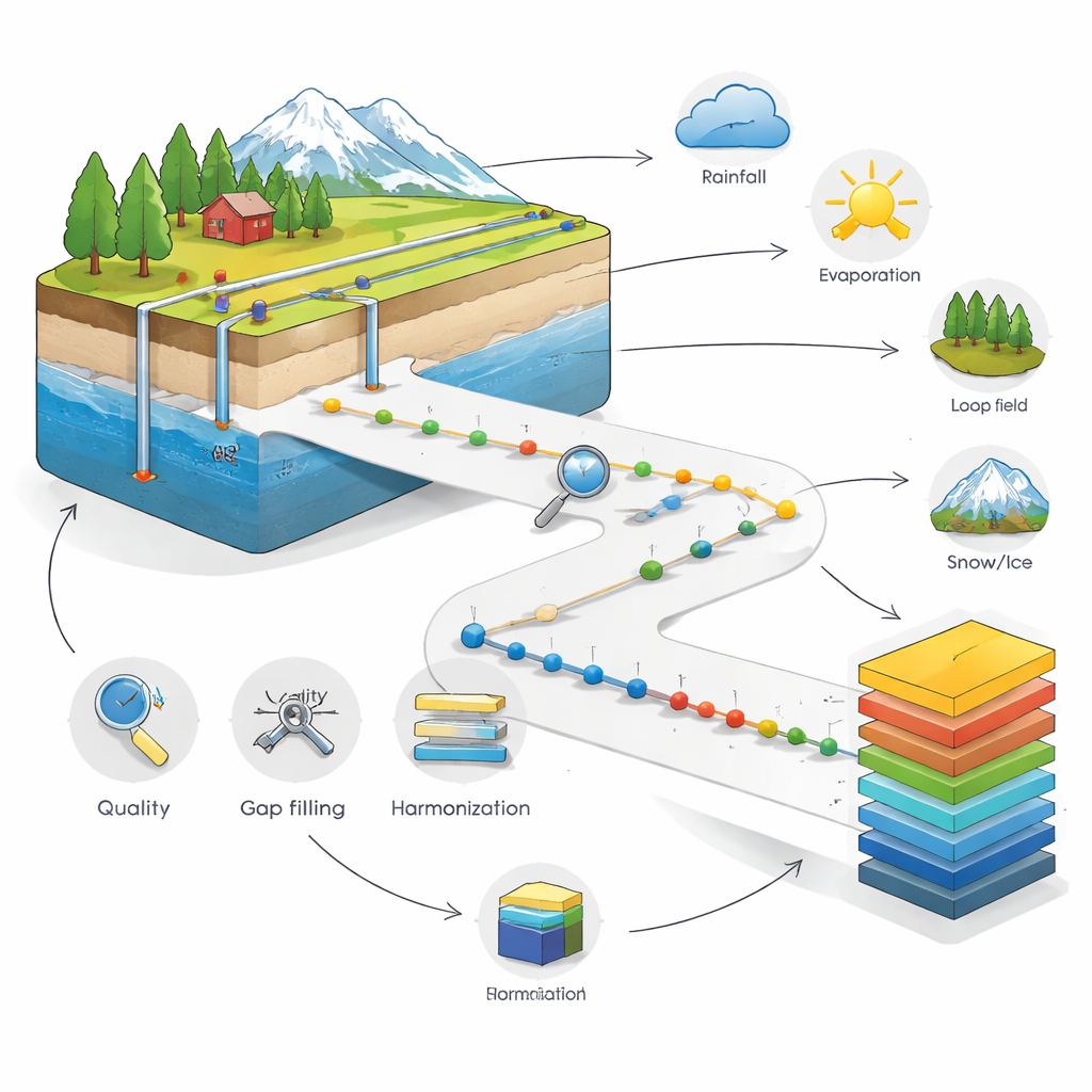
The GROW project assembles more than 200,000 groundwater time series from wells in 55 countries into a single, harmonized package. Most of the data come from North America, India, Europe, and Australia, where monitoring networks are well established. For each well, the dataset records how deep the water table is or how high the groundwater level stands over time, at daily, monthly, or yearly steps. About half of the records span at least a decade, and some stretch back more than a century. By gathering these measurements and putting them into a consistent format, GROW offers an unprecedented view of how groundwater levels rise and fall across a wide range of climates and landscapes.
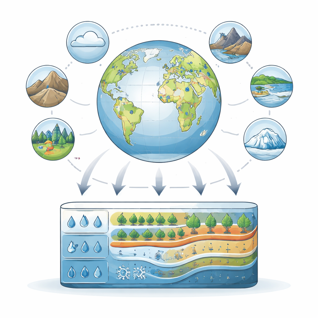
Connecting Groundwater to the Rest of the Planet
Groundwater does not act in isolation. It is influenced by rain and evaporation from the air, by the type of rocks and soils below, by rivers and lakes nearby, by snow and ice, by vegetation, and by human activities such as farming and pumping. To capture these links, the GROW team attached 36 additional variables to each groundwater record. These variables are grouped into six components of the Earth system: atmosphere, geosphere, hydrosphere, cryosphere, biosphere, and anthroposphere. For example, each well is paired with records of precipitation, potential evaporation, air temperature, land cover, water use, snow cover, and more. This allows researchers to explore questions such as how climate zones shape recharge, how land use affects water tables, or how snowmelt and glaciers feed underground stores.
Cleaning, Standardizing, and Flagging the Data
Bringing together so many measurements from many agencies and studies is not as simple as stacking them in a spreadsheet. The authors apply a detailed quality-control procedure to make the data “analysis-ready.” They remove empty and duplicate records, standardize the way groundwater levels are referenced, and harmonize the timing so that each time series has regular daily, monthly, or yearly steps. Gaps are allowed only up to a modest limit, and remaining gaps are filled in cautiously, with rules designed to reduce distortion of natural patterns. The team also runs automated checks to flag suspicious features such as long stretches of identical readings, sudden jumps, or unusual spikes that may signal sensor problems or other errors. In total, nearly one in five original time series is discarded for failing to meet these standards, and 34 different flags are stored to help users filter and judge the remaining data.
What the Dataset Reveals About Coverage and Bias
The authors carefully examine where and under what conditions the wells in GROW are located. Most wells tap relatively shallow groundwater—typically less than 10 meters below the surface—and cluster in temperate and dry climates with strong human influence, such as croplands and urban areas. Regions with fewer resources and monitoring programs, including many water-scarce hotspots, are underrepresented. High mountains, polar regions, and deep aquifers also appear less often. The paper stresses that these gaps and biases matter: they mean that global patterns derived from GROW may underestimate problems such as groundwater depletion in poorly monitored areas, and that some processes related to snow, ice, or permafrost are harder to analyze with statistical confidence.
How Researchers and Planners Can Use GROW
Despite these limitations, GROW opens new possibilities for studying groundwater on a global scale. Because the dataset is standardized and freely available, scientists can apply the same methods across many regions to look for common drivers of water table changes, or to identify groups of wells that behave similarly under shared environmental conditions. The combined groundwater and Earth-system information is well suited for machine learning and other data-driven tools that can detect hidden patterns and test ideas about how groundwater responds to climate and land use. Modelers can also use GROW to calibrate and evaluate large-scale hydrological and climate models, improving their ability to represent underground water. The authors present GROW as a first, static release of a long-term effort and invite the global community to contribute more data, especially from regions currently missing.
Why This Work Matters for Society
For a lay reader, the key message is that understanding groundwater is essential for securing water supplies, protecting ecosystems, and planning for climate change, but we have lacked the kind of global, time-varying data that exist for rain, rivers, or temperature. GROW helps fill that gap by turning scattered well records into a coherent, richly annotated resource. While it does not yet cover every region or type of aquifer, it gives scientists and decision-makers a powerful new tool to see how the planet’s hidden water reserves are changing, to probe the causes behind those changes, and ultimately to guide more sustainable use of this vital but often overlooked resource.
Citation: Bäthge, A., Vargas, C.R., Lischeid, G. et al. A Global-Scale Time Series Dataset for Groundwater Studies within the Earth System. Sci Data 13, 401 (2026). https://doi.org/10.1038/s41597-026-06966-1
Keywords: groundwater, global hydrology, water resources, climate impacts, Earth system data