Clear Sky Science · en
A multi-label dataset for China’s agricultural and rural scenes classification from VHR satellite imagery
Why mapping the countryside from space matters
Across China, the countryside is changing fast: new greenhouses appear in old fields, solar farms spread over hillsides, and roads knit once-isolated villages together. Yet most satellite-based maps still treat all of this as a single bland category like “agriculture.” This article introduces China‑MAS‑50k, a new open dataset that lets computers see rural China in far more detail, using very sharp satellite images and multiple labels per scene. It offers a foundation for better tracking of food production, rural development, and environmental change at a national scale.
Seeing more than one thing at a time
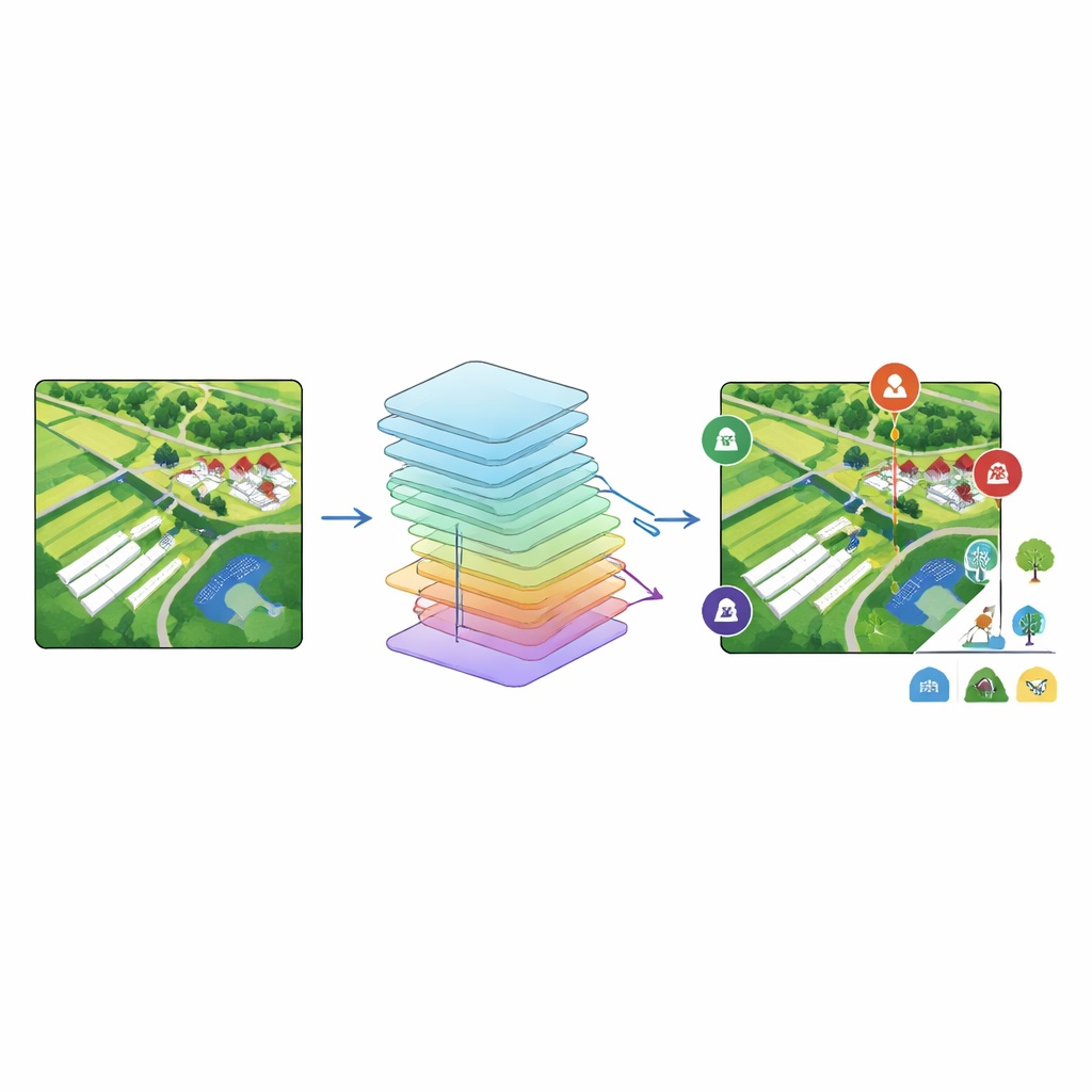
Traditional satellite maps usually assign just one label to each image patch—forest, city, or cropland, for example. Real places are rarely that simple: a single aerial snapshot might show a village, surrounding fields, a pond, a road, and modern structures like solar panels or plastic-covered greenhouses all at once. The China‑MAS‑50k project embraces this complexity by treating each image as a mix of elements. Instead of forcing a choice, it allows many labels to be attached to the same picture, better matching how people actually see and use the land.
Building a detailed picture of rural China
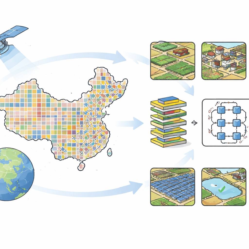
To construct the dataset, the team started with freely available, very‑high‑resolution imagery from Google Earth, mainly from modern commercial satellites capable of showing features just over a meter wide. They overlaid a 50‑kilometer grid on all of China to spread sampling evenly, then chose points in rural areas and downloaded small 512‑by‑512‑pixel image tiles at each point. Images with too many clouds, snow, blur, or a single uniform surface were filtered out, leaving 55,520 clear scenes collected mainly in 2023–2024. These tiles span the country’s diverse landscapes, but are especially dense in the more intensively farmed regions east of the famous “Hu Line,” where most of China’s people and cropland are found.
Turning pixels into meaningful land types
The researchers designed an 18‑category label system tailored to rural life. It includes natural surfaces such as cropland, woodland, grassland, rivers, lakes or ponds, bare land, and roads and railways, as well as human-made features such as rural villages, factories, sports fields, parks, plastic mulch, greenhouses, photovoltaic (solar) stations, dust‑proof nets used on construction sites, and piles of solid waste. Human annotators followed detailed visual guidelines describing typical colors, textures, and shapes—for instance, tree shadows indicating woodland, long bright strips for greenhouses, dark panels in neat rows for solar farms. Using an open annotation tool, three experts labeled each image with all visible categories, cross‑checking one another’s work to catch mistakes. The result is 135,289 labels, organized so that each image can easily be paired with its full list of land‑cover types.
Testing how smart machines really are
With this new benchmark in hand, the authors evaluated a range of popular computer models. These included classic machine‑learning methods based on decision trees, and deeper neural networks originally designed for tasks like photo recognition. All models received the same three‑color image inputs and were asked to predict which of the 18 categories appeared in each scene. Overall, modern deep networks outperformed the older approaches. Among them, a model called ResNeXt‑101 delivered the best balance of accuracy measures, capturing most common elements such as cropland, woodland, and roads reasonably well. However, it struggled with rarer features like dust‑proof nets, plastic mulch, and solar stations, revealing how hard it is for algorithms to learn from limited examples in a “long‑tailed” dataset where a few classes are common and many are scarce.
What this means for future rural insights
China‑MAS‑50k offers more than just a large collection of pretty satellite snapshots. It is a carefully checked, open resource that reflects the true variety of China’s rural landscapes and the uneven spread of traditional and modern agriculture. By allowing multiple labels per image, it can support advanced tasks such as weakly supervised mapping, where computers learn to outline fields, greenhouses, or roads using only coarse scene‑level tags. It also provides a realistic test bed for tackling class imbalance, a key bottleneck in applying artificial intelligence to messy real‑world data. In plain terms, this dataset makes it easier for scientists and planners to teach computers what is actually happening on the ground in rural China, and to track how those places continue to change over time.
Citation: Yuan, S., Feng, Q., Niu, B. et al. A multi-label dataset for China’s agricultural and rural scenes classification from VHR satellite imagery. Sci Data 13, 384 (2026). https://doi.org/10.1038/s41597-026-06800-8
Keywords: remote sensing, rural landscapes, agricultural mapping, multi-label datasets, satellite imagery