Clear Sky Science · en
Synthesised database of wild bee and hoverfly records in Europe
Why tiny fliers matter to all of us
Across Europe, wild bees and hoverflies silently keep our farms, gardens and natural landscapes alive by moving pollen from flower to flower. Yet many of these insects are disappearing, and until now scientists and policymakers have struggled with a basic problem: no single, reliable map showed where these species actually live or how their distributions may be changing. This study brings together millions of records scattered across museums, notebooks, national databases and citizen-science platforms into two unified, checked and publicly available databases for Europe’s wild bees and hoverflies.
Bringing scattered records under one roof
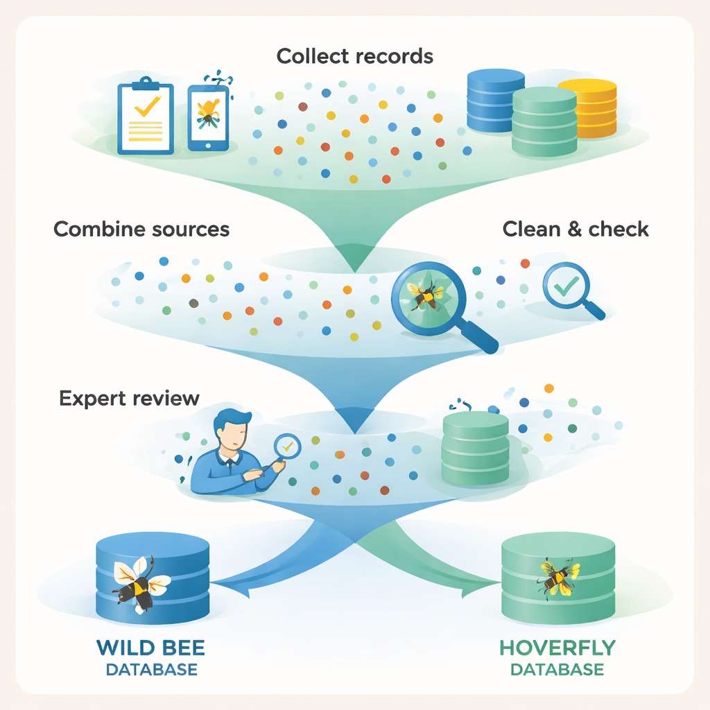
For decades, information on wild pollinators has been collected by taxonomists, national experts, nature organisations and keen amateurs. But these records sat in separate silos: paper labels pinned to old museum specimens, spreadsheets on personal computers, and online portals that did not talk to each other. The authors of this study set out to assemble a single, Europe-wide picture for two key groups of pollinators: wild bees and hoverflies. They contacted specialists across Europe, tapped into earlier European projects, drew on public repositories and open-access portals, and even digitised records locked in published papers and historical collections. The result is a vast raw trove of more than five million observations that could finally be compared and analysed together.
Turning raw sightings into trustworthy data
Simply piling all these records into one file would not be enough; different sources used different formats, names and levels of accuracy. The team first agreed on a shared template they call the “Pollinator Core”, designed to be compatible with existing international standards but tailored to pollinators. Every record had to include at least the species name and the place it was found. The researchers then standardised dates, turned a jumble of coordinate formats into modern latitude–longitude values, translated sex and counting information into a common code, and added consistent country and regional labels using digital maps. They also quantified how uncertain each location was, so future users can judge how precisely each record pinpoints a spot on the ground.
Checking names, places and possible errors
Names of insects change over time as scientists refine their understanding, and mis-typed labels are common in large collections. To tackle this, the authors built detailed “taxonomic dictionaries” for bees and hoverflies, combining the most up-to-date European checklists with long lists of known spelling errors and outdated names. Software tools and fuzzy matching techniques helped find and correct likely mistakes, while records that could not be reliably identified were removed. The team also checked whether each point fell within Europe’s agreed geographic boundaries and on land rather than in the sea. For hoverflies, they could safely delete exact duplicate records; for bees, the structure of some datasets made this too risky, so potential duplication is acknowledged as a minor limitation rather than scrubbed away blindly.
Expert eyes on millions of points
Even after automated cleaning, the databases were not considered finished until human experts had their say. Bee records were split into groups by family or tribe, and specialists were given maps and tables to review. They flagged suspicious points, added overlooked records where they knew species should occur, and repeated this process until distributions looked realistic. For hoverflies, specialists used mapping software to scan for odd records and consulted regional experts when needed. This step removed hundreds of thousands of doubtful bee records and dozens of hoverfly records, while adding nearly 900,000 trusted bee observations. Special labels were also added where necessary, such as for a set of historical bee records that describe general ranges rather than individual specimens.
A new foundation for protecting pollinators
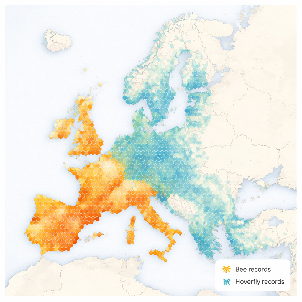
The final product is two harmonised occurrence databases containing about 4.34 million bee records and 1.04 million hoverfly records, covering 97% of the known species in each group across Europe. These data are openly available through the Zenodo platform and will be maintained as living resources with future updates through major EU projects. For non-specialists, the key message is simple: we now have the most complete, carefully checked map yet of where Europe’s wild bees and hoverflies are found. This will help scientists measure declines, identify hotspots that need protection, design smarter farm and land policies, and track whether conservation laws are working—essential steps if we hope to keep our crops, wildflowers and ecosystems buzzing.
Citation: Sentil, A., Miličić, M., Benrezkallah, J. et al. Synthesised database of wild bee and hoverfly records in Europe. Sci Data 13, 227 (2026). https://doi.org/10.1038/s41597-026-06644-2
Keywords: pollinators, wild bees, hoverflies, biodiversity data, Europe