Clear Sky Science · en
Vulcano island: the new high resolution digital surface model post 2021-2022 volcanic unrest
A Volcanic Island Mapped in Unprecedented Detail
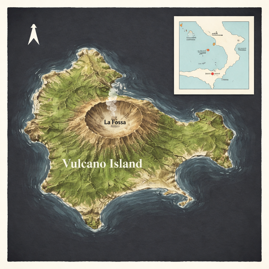
Vulcano, a small island in the Tyrrhenian Sea north of Sicily, is famous both for giving volcanoes their name and for living restlessly between calm and crisis. After a worrying surge in gas emissions, small earthquakes and ground movement in 2021–2022, scientists set out to create the most detailed three-dimensional map of the island’s surface ever produced. This digital model does not just satisfy scientific curiosity: it offers a powerful tool to understand landslides, coastal change and future volcanic hazards that can affect the people who live on and visit the island.
Why Watch Every Bump on a Volcano
Active volcanoes are constantly reshaped by eruptions, earthquakes, heavy rains and even human activity. Subtle changes in the ground—new cracks, bulging slopes, shifting beaches—can signal rising magma or unstable hillsides long before disaster strikes. On Vulcano, decades of moderate unrest and a historic explosive eruption in the late 1800s have left a complex landscape of craters, cones and steep slopes. During the 2021–2022 crisis, gas temperatures and compositions shifted dramatically, carbon dioxide poured from the soil at higher rates and swarms of small quakes rattled the island. Authorities declared a state of emergency. To understand what had changed and to be ready for what might come next, researchers needed an updated, ultra-precise picture of the island’s surface.
Scanning the Island from the Sky
On August 4, 2023, a small aircraft flew back and forth over Vulcano carrying a sophisticated laser scanner and camera system. The laser instrument, known as airborne LiDAR, fired hundreds of thousands of near‑infrared pulses every second toward the ground. Each pulse bounced back from the terrain, vegetation or buildings, allowing the system to record more than 220 million three‑dimensional points in just over half an hour. At the same time, a high‑resolution camera collected sharp color images of the island. Using precise GPS and motion sensors aboard the plane, the team positioned every laser point to within a few centimetres horizontally and vertically.
Turning Billions of Numbers into a Living Landscape
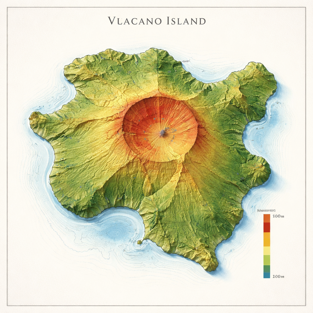
Back on the ground, the scientists cleaned and processed the dataset, removing spurious measurements and using specialized software to weave the remaining 137 million points into a seamless digital skin of the island. This product, called a Digital Surface Model, represents the height of everything on Vulcano—rock, soil, vegetation and buildings—at a spacing of just 50 centimeters. The model captures fine details such as individual terraces on cultivated slopes, structures in the harbor areas and even rows of beach umbrellas. Combining the laser data with the sharp aerial photos, the team also traced an extremely accurate coastline and cataloged hundreds of small offshore rocks that protrude above sea level.
Revealing Hidden Risks in the Terrain
The new model is not just pretty to look at; it is a measuring tool for past and future hazards. By examining slopes in detail, the researchers could sharply outline the scar of a landslide that struck the northeastern flank of Vulcano’s central cone in April 1988, likely triggered by heavy rain and earthquake activity. The digital elevation data allowed them to pinpoint where the slide began, how far the ground dropped—about 29 meters—and how wide and long the affected area is. Such precise information feeds directly into simulations of landslide‑generated tsunamis and into assessments of which areas might be at risk in future storms or renewed unrest. The carefully mapped coastline also supports studies of erosion, beach evolution and potential flooding from the sea.
Checking the Map Is Really That Good
To ensure the digital model is trustworthy, the team compared its elevations with measurements collected on the ground using high‑precision satellite receivers at 17 carefully chosen sites, along with data from three permanent GPS stations on the island. In most locations, the difference between the model and field measurements was only a few centimeters, and even in the worst cases it remained close to the expected uncertainty. Overall, the typical vertical error was about 8 centimeters—roughly the thickness of a paperback book—confirming that the digital model matches reality remarkably well across the island.
A New Baseline for Future Island Safety
For residents, emergency planners and scientists alike, this new digital surface model is a baseline snapshot of Vulcano taken after the 2021–2022 crisis. It is freely available for anyone to download and use. Future surveys can be compared against it to spot even small changes in the shape of the volcano, the stability of its flanks or the position of its shores. In simple terms, the study has given Vulcano one of the sharpest “3D portraits” ever made of an active volcanic island, turning raw laser pulses into practical knowledge that can help protect people and property from the restless forces beneath their feet.
Citation: Bisson, M., Gianardi, R., Iacono, F. et al. Vulcano island: the new high resolution digital surface model post 2021-2022 volcanic unrest. Sci Data 13, 286 (2026). https://doi.org/10.1038/s41597-026-06623-7
Keywords: volcano monitoring, Vulcano Island, LiDAR mapping, landslide hazard, digital terrain models