Clear Sky Science · en
A Machine Learning approach for Total Water storage anomaly eXtension back to 1980 (ML-TWiX)
Why long-term water changes matter
How much water is stored on land—in soil, snow, rivers, lakes, and underground—changes from month to month and decade to decade. These shifts affect droughts, floods, food production, and even global sea level. Satellites have given us a powerful, planet-wide view of these changes only since the early 2000s, which is too short to fully understand long-term climate patterns. This study introduces ML-TWiX, a machine-learning based reconstruction that stretches our global record of land water storage changes back to 1980, helping scientists and decision-makers see multi-decade trends in Earth’s water cycle.
Seeing hidden water from space
Satellites from the GRACE and GRACE Follow-On missions do not see water directly. Instead, they measure tiny changes in Earth’s gravity caused by water moving around the planet. From those gravity shifts, scientists infer “total water storage anomalies” – how much the amount of water stored on land differs from its long-term average. These data have transformed our understanding of groundwater depletion, long-lasting droughts, river-basin floods, and contributions of land water to sea-level rise. But GRACE-style observations only cover about two decades, leaving too short a record to robustly detect slow climate-driven trends or to compare today’s extremes with those of the recent past.
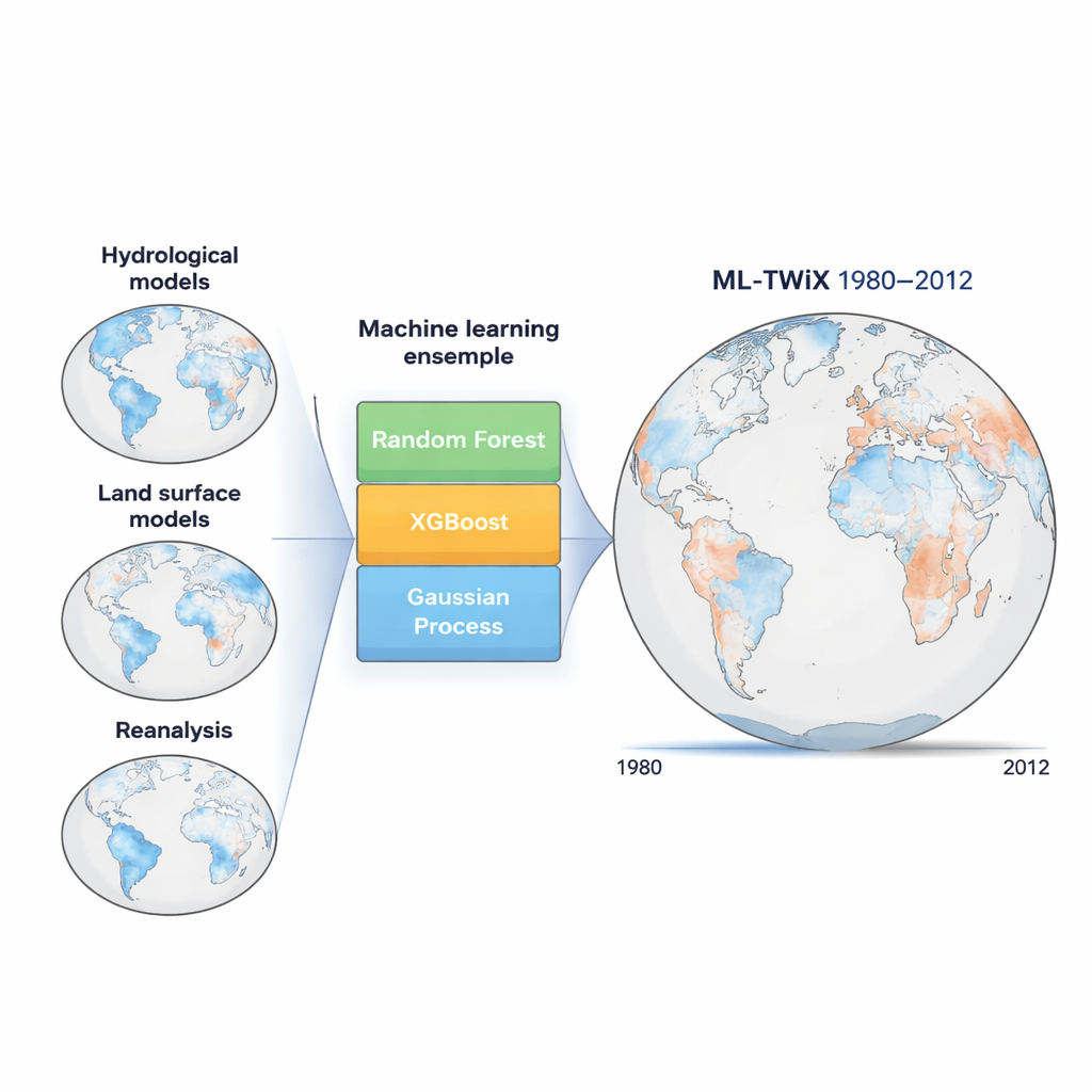
Teaching computers to learn from models
To go beyond what the satellites alone can provide, the authors turn to machine learning. Many computer models already simulate how water moves and is stored on land, but each model has blind spots—some handle snow well but miss groundwater, others include human water use but simplify rivers, and so on. ML-TWiX takes the output from thirteen such global models, covering 1980–2012, and uses GRACE observations during 2002–2012 as a training target. Three different learning algorithms—Random Forest, XGBoost, and Gaussian Process Regression—are taught, grid cell by grid cell, how to combine the models so that their joint output matches what GRACE actually saw when it was flying.
Building a stronger picture by combining many views
Rather than trusting a single technique, ML-TWiX uses an ensemble approach. Each of the three machine learning methods is trained multiple times with slightly different settings, then all of their predictions are averaged. This pooling reduces the impact of any one model’s quirks and makes the final product more robust across climates from humid tropics to dry deserts and snow-dominated high latitudes. Importantly, the spread among the ensemble members is also recorded, giving a map of uncertainty that tells users where the reconstruction is more or less reliable. Uncertainty tends to be higher in regions with very dynamic water cycles, such as the Amazon and monsoon areas, and lower in more arid regions where storage changes are smaller.
Putting the new record to the test
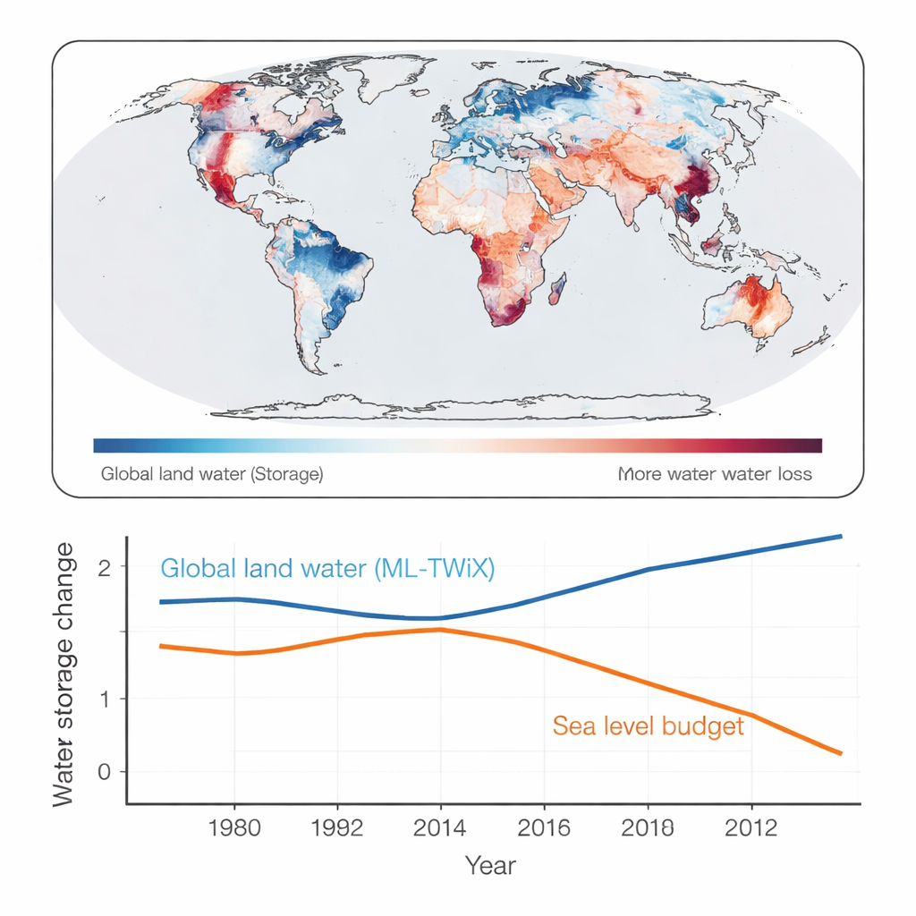
The authors do not simply trust the machine learning output; they check it against several independent lines of evidence. First, during the years when GRACE was operating, the reconstructed water storage closely tracks the satellite record across hundreds of large river basins, with very high correlations and low errors. Second, they compare ML-TWiX to estimates derived from satellite laser ranging, an older technique that also senses gravity changes, and find that the new dataset matches that signal about as well as GRACE itself does. Third, they test whether month-to-month changes in reconstructed storage are consistent with the basic water-balance equation relating rainfall, evaporation, and river runoff. Finally, they use a global sea-level budget: when land stores more water, the oceans should temporarily drop, and vice versa. ML-TWiX’s global average agrees well with sea-level-based estimates, particularly during the satellite era.
What this means for understanding Earth’s water future
For non-specialists, ML-TWiX can be thought of as a smart, data-driven “translator” between many imperfect computer simulations and a short but highly trusted satellite record. By learning how those simulations behaved during the GRACE years, it can replay similar relationships back to 1980, filling in more than two extra decades of monthly global maps of land water storage change. While the reconstruction is less certain before satellites were available and cannot capture everything—especially where climate or human water use may have changed in new ways—it still offers one of the most consistent and rigorously tested pictures yet of how Earth’s land water has shifted over recent decades. That longer view should help researchers and planners better place today’s droughts, floods, and water stresses into a broader historical and climate context.
Citation: Saemian, P., Tourian, M.J., Douch, K. et al. A Machine Learning approach for Total Water storage anomaly eXtension back to 1980 (ML-TWiX). Sci Data 13, 142 (2026). https://doi.org/10.1038/s41597-026-06604-w
Keywords: terrestrial water storage, GRACE satellites, machine learning hydrology, global water cycle, sea level change