Clear Sky Science · en
Reconstruction of Extreme Sea Levels in coastal China using Multiple Deep Learning models
Why coastal water levels matter to everyday life
China’s long coastline is home to hundreds of millions of people, major ports, and booming cities. When powerful storms push the sea inland, the resulting high water levels can flood neighborhoods, damage infrastructure, and contaminate drinking water with salt. Yet detailed records of such extreme coastal water levels are surprisingly scarce and fragmented. This study fills that gap by reconstructing fifty years of daily high-water levels along much of China’s coast, using modern artificial intelligence tools to turn patchy observations and weather reanalysis data into a consistent, publicly available dataset.
Tracking the rise and fall of the sea
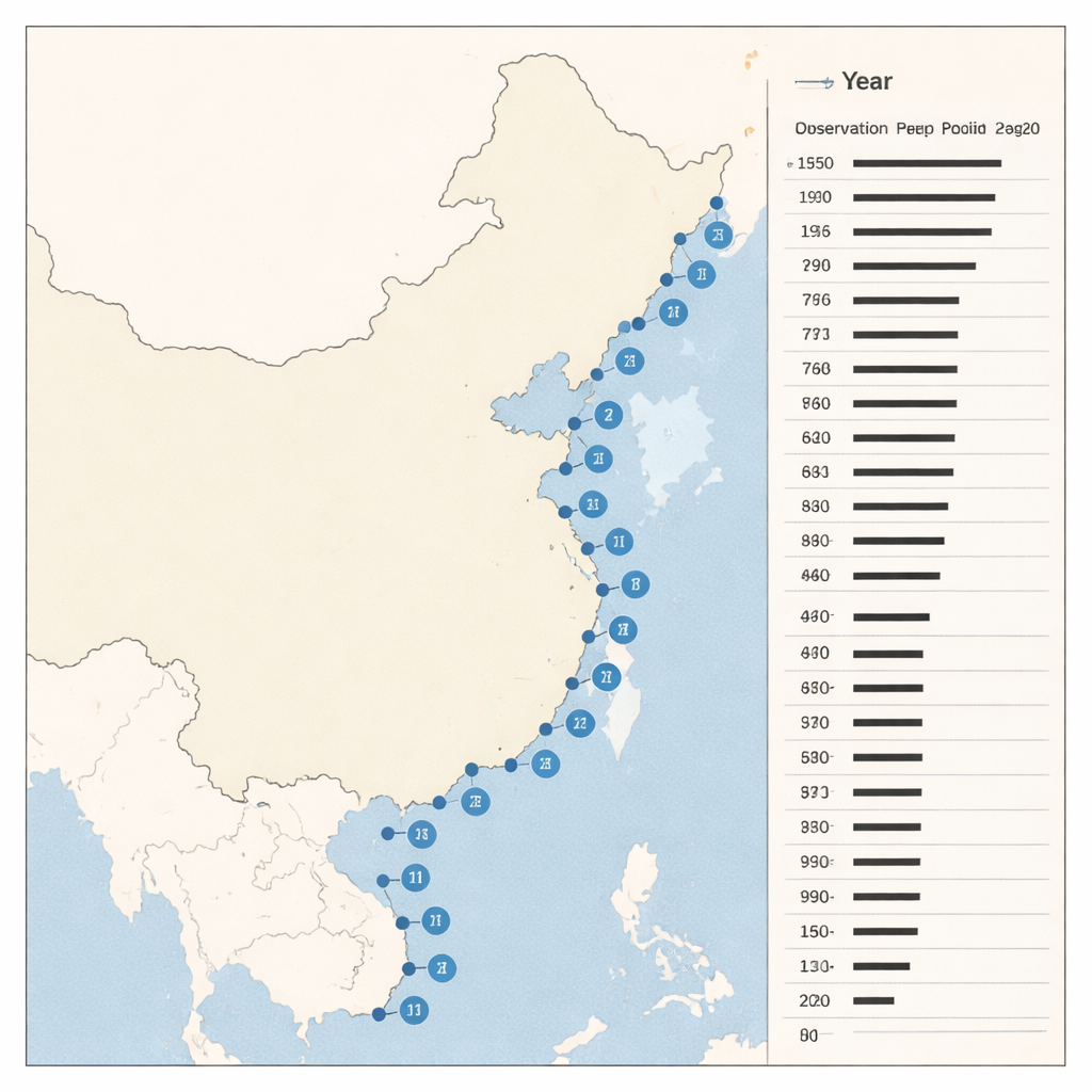
Coastal water levels are driven by two main ingredients: the regular pull of the Moon and Sun that creates tides, and storm surges, which are temporary bulges of water pushed ashore by low air pressure and strong winds during cyclones and other weather systems. In China, tropical cyclones and other storms often arrive on top of already high tides, creating especially dangerous conditions. However, many tide-gauge stations that measure sea level have only short or intermittent records, and some are not publicly accessible. That makes it difficult for scientists and planners to understand how extreme sea levels vary from place to place and from decade to decade along this heavily exposed coastline.
Using smart models to fill in the blanks
The authors approached this problem by combining modern deep learning techniques with traditional tide analysis. They focused on 23 tide-gauge stations scattered along China’s coast and gathered detailed weather information from the ERA5 global reanalysis, including air pressure and near-surface winds over a 10-by-10-degree box around each station. These weather patterns were used to teach several types of neural networks how daily maximum storm surges relate to the surrounding atmosphere. At the same time, the team used a tool called UTide to extract the predictable tidal signals from the historical sea-level records, allowing them to separate the regular rise and fall of the tide from the more erratic surge component.
Testing different flavors of deep learning
Rather than relying on a single algorithm, the study systematically compared four deep learning models: a Long Short-Term Memory (LSTM) network, a hybrid CNN-LSTM that first reads spatial patterns, a ConvLSTM that handles space and time together, and an Informer model based on the Transformer architecture popularized in language processing. To keep the models efficient, the researchers compressed the large weather fields using principal component analysis before training. They also fed each model a 24-hour history of atmospheric conditions and used attention mechanisms so the network could focus on the most important moments. For every station, they reserved about 20% of the record as an independent test period and selected whichever model performed best there for the final reconstruction.
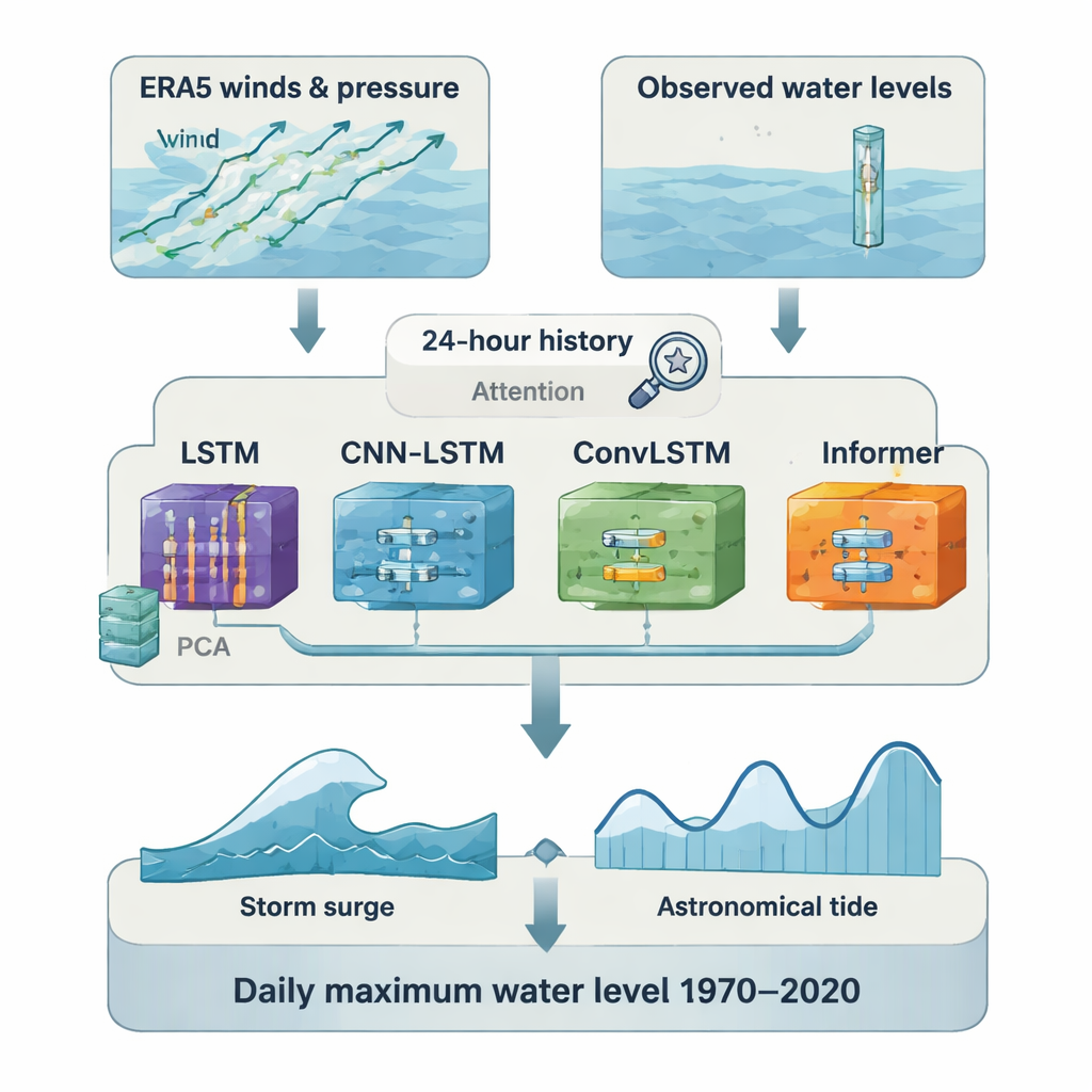
Rebuilding fifty years of high water
Once trained, the best-performing model at each site was used to reconstruct daily maximum storm surges for the entire 1970–2020 period. These surge estimates were then added to the corresponding astronomical tides from UTide to produce daily maximum total water levels. Because the highest tide and the highest surge on a given day usually occur at slightly different times, this simple addition represents an upper bound on what actually happened; tests with hourly data suggest this overestimate averages about 15 centimeters, or roughly 15%. Even with this conservative bias, the reconstructed series closely match observed records where data exist: on average, the correlation between reconstructed and observed daily maxima is about 0.9, and errors are on the order of a few tens of centimeters, including for very high-water events above the 95th percentile.
What this means for coasts and communities
For scientists, engineers, and coastal planners, the new dataset provides a detailed, consistent picture of how extreme sea levels have behaved along China’s coast over the past half century. It outperforms several widely used global products, especially during typhoons and other extremes, and comes with full metadata, code, and performance metrics so others can reuse and scrutinize it. For the wider public, this work means that assessments of flood risk, sea-wall design, evacuation planning, and long-term adaptation can now draw on far richer information than was previously available. In plain terms, by teaching computers to “replay” decades of storm-driven high tides, the study offers a stronger scientific foundation for protecting coastal communities from today’s hazards and preparing for tomorrow’s rising seas.
Citation: Fang, J., Huang, J., Bian, W. et al. Reconstruction of Extreme Sea Levels in coastal China using Multiple Deep Learning models. Sci Data 13, 268 (2026). https://doi.org/10.1038/s41597-026-06593-w
Keywords: storm surge, extreme sea level, coastal flooding, deep learning, China coastline