Clear Sky Science · en
A new, long-term root zone soil moisture dataset for operational agricultural drought monitoring over Africa
Why water hidden in soil matters
When we think about drought, we often picture empty rivers and cloudless skies. But for crops, the real crisis happens underground, where roots search for water in the soil. Across Africa, millions of farmers depend on this hidden moisture, yet until now it has been extremely difficult to monitor what is happening below the surface, day by day and year after year. This article introduces a new continent‑wide dataset that tracks how much water is available to plant roots, offering a powerful tool for protecting harvests and managing food security.
A closer look beneath the surface
Rain gauges and satellite rainfall maps are widely used to monitor African droughts, but rain alone does not tell the whole story. Hot, dry air can quickly pull water back into the atmosphere, and many satellites only sense moisture in the top few centimetres of soil, not at the depths where crop roots feed. The new TAMSAT soil moisture dataset (TAMSAT‑SM) focuses on root zone soil moisture – the water stored in roughly the top metre of soil that crops can actually use. It covers Africa from 1983 to the present at a quarter‑degree resolution, providing daily information on how wet or dry the root zone is, along with related water‑cycle variables such as rainfall, evaporation and runoff. 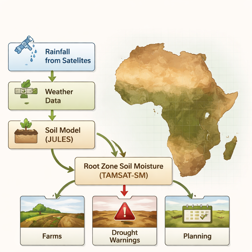
How the new system builds its picture
Instead of trying to measure deep soil water directly everywhere, the team uses a sophisticated land surface model called JULES. This model represents how rain enters the soil, how water moves between soil layers, how plant roots draw it up, and how it leaves again through evaporation and runoff. JULES is driven by long‑running TAMSAT satellite rainfall estimates and by daily weather data from a global reanalysis, ensuring a continuous record with no gaps. To make the simulated soil moisture more realistic, the researchers tune the model using high‑quality satellite observations from NASA’s SMAP mission, adjusting how different soil types hold and transmit water so that the top layer of the model behaves more like what the satellite sees.
Turning complex physics into usable drought signals
The dataset provides not only the amount of water in each of four soil layers down to three metres, but also a plant‑focused indicator called the soil moisture availability factor, or beta. For each vegetation type, beta expresses how stressed plants are by lack of water on a scale from 0 to 100, where 0 means permanent wilting and 100 means no water stress. For agriculture, the authors highlight beta for so‑called C4 grasses, a category that includes major African staples such as maize, sorghum and millet. Because the data are daily and updated within a week, users can track how soil water stress builds during a season and map where crops are most at risk, then combine this with longer‑term statistics to judge whether conditions are unusually severe.
Checking reliability against other views of drought
To test how trustworthy TAMSAT‑SM is, the authors compare it to several other prominent root zone soil moisture products and to a satellite‑based vegetation health index. Across most of sub‑Saharan Africa, the new dataset shows similar seasonal patterns to existing models, even though the absolute moisture values can differ. In East and Southern Africa, where drought risk is high, the timing of wet and dry swings closely matches other datasets, and TAMSAT‑SM tracks SMAP‑based soil moisture particularly well. The beta indicator also lines up with independent measures of vegetation health across the Sahel, East Africa and Southern Africa: years with low soil moisture availability tend to coincide with poor plant condition, and wetter years with healthier vegetation. 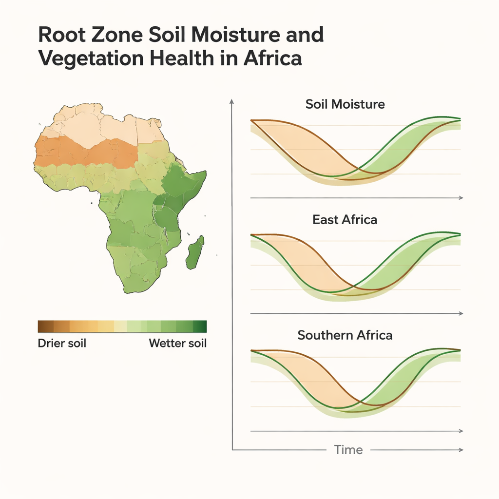
What this means for farmers and planners
For non‑specialists, the key message is that we now have a long, consistent and near‑real‑time record of how much water crops can actually reach with their roots across almost all of Africa. This makes it possible to monitor agricultural drought more directly than using rainfall alone, to see how current conditions compare with past decades, and to link present stress to likely impacts on vegetation. Because TAMSAT‑SM is designed to work with existing TAMSAT rainfall data and a companion forecasting system, it can feed into early warning, insurance products and planting‑date advice. The authors caution that exact moisture numbers should be used carefully, but show that relative measures – how much wetter or drier than normal the soil is – provide a robust, practical guide for anticipating and managing drought‑related risks to food production.
Citation: Maidment, R.I., Quaife, T., Pinnington, E. et al. A new, long-term root zone soil moisture dataset for operational agricultural drought monitoring over Africa. Sci Data 13, 260 (2026). https://doi.org/10.1038/s41597-026-06585-w
Keywords: soil moisture, agricultural drought, Africa climate, satellite rainfall, crop water stress