Clear Sky Science · en
A Dataset of Vertical Carbon Fluxes from a Georgia Tidal Salt Marsh from 2014 to 2024
Why this marsh matters for the climate
Tidal salt marshes do quiet but important work for the planet: they pull carbon dioxide out of the air, store it in plants and mud, and can help slow climate change. Yet these watery landscapes are constantly shaped by tides, storms, and rising seas, making their long‑term behavior hard to predict. This paper presents a decade of careful carbon measurements from a Georgia salt marsh, offering one of the most detailed records yet of how such “blue carbon” systems breathe in and out carbon over time.
A decade watching a living shoreline
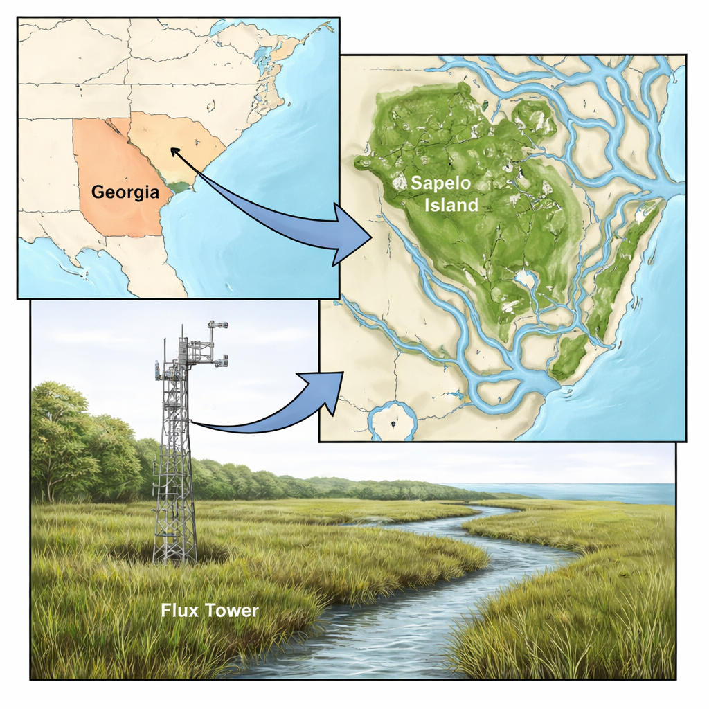
The study focuses on a marsh dominated by the grass Spartina alterniflora on Sapelo Island, off the coast of Georgia. Since late 2013, researchers with the Georgia Coastal Ecosystems Long Term Ecological Research program have run a tall metal tower in the middle of the marsh. This tower continuously tracks how much carbon dioxide moves between the marsh surface and the atmosphere. The marsh experiences twice‑daily tides that flood and drain the flat grassy plain, with salty water flowing in from nearby creeks. Different patches of the marsh host short, medium, and tall Spartina plants, all of which contribute to the carbon signal the tower sees.
Listening to the wind to measure carbon
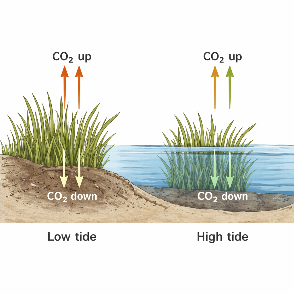
The team used a technique called eddy covariance, which essentially listens to tiny gusts of wind and the carbon they carry. Fast sensors mounted about five meters above the marsh record three‑dimensional wind speed and carbon dioxide concentration ten times per second. By pairing those signals, the method reveals whether the ecosystem, as a whole, is taking up carbon (acting as a sink) or releasing it (acting as a source). From these measurements they calculated three key quantities at 30‑minute intervals: net ecosystem exchange (the overall gain or loss of CO2), respiration (carbon released by plants and soils), and gross primary production (carbon taken up by photosynthesis). They then summed these values into daily and yearly totals.
Making sense of gaps, tides, and uncertainties
Real‑world measurements in a harsh coastal setting are messy. Instruments occasionally fail, maintenance work disrupts the air flow, and the marsh itself changes as plants grow, die back, and are submerged by tides. To handle missing or unreliable data, the authors turned to modern machine‑learning methods, using an algorithm called XGBoost to predict carbon exchange during unmeasured periods. These models learned from high‑quality data and from many environmental cues, such as light, temperature, wind, water level, and time of day or year. The team also paid special attention to tides: when the marsh floods, water covers plant leaves and traps carbon coming from the soil, reducing the vertical exchange that the tower can see. By feeding water‑level information and seasonal plant height into their models, they captured these tidal effects more realistically than standard land‑based approaches.
How reliable are these numbers?
Because carbon budgets hinge on trust in the data, the authors carefully quantified uncertainty at every step. They combined random measurement noise, the spread among multiple machine‑learning models, and the added uncertainty introduced when splitting total exchange into respiration and photosynthesis. Using repeated simulations, they produced 95% confidence ranges for every 30‑minute, daily, and yearly value. They also document exactly when each of two sensor systems was used and what fraction of each day or year relied on modeled rather than direct measurements. One full year (2018) lacked tower data entirely, so its fluxes are based solely on model predictions and should be treated with extra caution.
Opening a window into blue carbon futures
The final result is an openly available, science‑ready dataset covering ten years of vertical carbon fluxes in a tidal salt marsh. Researchers can use it to test satellite estimates of plant growth, refine models of coastal carbon budgets, and explore how marshes respond to changing weather, drought, and sea‑level rise. For a layperson, the takeaway is straightforward: this work turns a single marsh into a long‑running climate observatory, showing in fine detail how a living shoreline stores and releases carbon. Such records are essential if we want to know how much these coastal ecosystems can help in the fight against climate change—and how to protect them so they keep doing that job.
Citation: Hawman, P.A., Mishra, D.R. A Dataset of Vertical Carbon Fluxes from a Georgia Tidal Salt Marsh from 2014 to 2024. Sci Data 13, 251 (2026). https://doi.org/10.1038/s41597-026-06571-2
Keywords: salt marsh, blue carbon, carbon flux, tidal wetlands, eddy covariance