Clear Sky Science · en
An Extended VIIRS-like Artificial Nighttime Light Data Reconstruction (1986–2024)
Why the glow of cities from space matters
When astronauts look down at Earth at night, they see bright webs of light tracing cities, towns, and roads. Those glowing patterns are more than beautiful pictures: they are a surprisingly accurate mirror of where people live, work, and consume energy. This paper introduces a new, long-term dataset of China’s nighttime lights, reconstructed from 1986 to 2024, that lets researchers and policymakers track nearly four decades of urban growth, economic change, and environmental pressure with much finer detail than before.
The challenge of measuring nights across decades
Satellites have been recording city lights since the early 1990s, but the record is messy. Older sensors, known as DMSP-OLS, captured coarse, often saturated images where the brightest downtowns all looked equally white and flat. Newer VIIRS sensors, operating since 2012, see much subtler differences in brightness and much finer structures, such as the shape of city blocks and major roads. However, the old and new systems use different technologies and scales, so their data cannot be simply stitched together. Earlier attempts to create “VIIRS-like” long-term records either dimmed the true brightness of cities or blurred away important details inside urban areas.
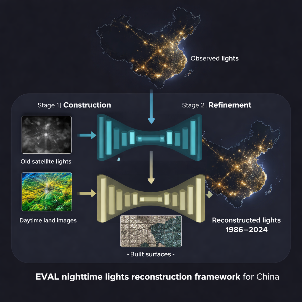
A two-step recipe for rebuilding the night
The authors propose a two-stage deep-learning framework to overcome these limitations and build the Extended VIIRS-like Artificial Nighttime Light (EVAL) dataset. In the first stage, a U-shaped neural network takes older nighttime light observations together with daytime Landsat imagery, which describes land cover like water, fields, and built-up areas. This network produces an initial guess of what a modern VIIRS-style view would look like for each year back to the 1980s. In the second stage, a separate refining module brings in a very detailed map of impervious surfaces—concrete, asphalt, and buildings at 30-meter resolution—to sharpen the structure of cities and transport corridors. This extra information helps the model restore the “texture” of urban fabric and road networks that older sensors never clearly recorded.
Sharper city lights and clearer roads
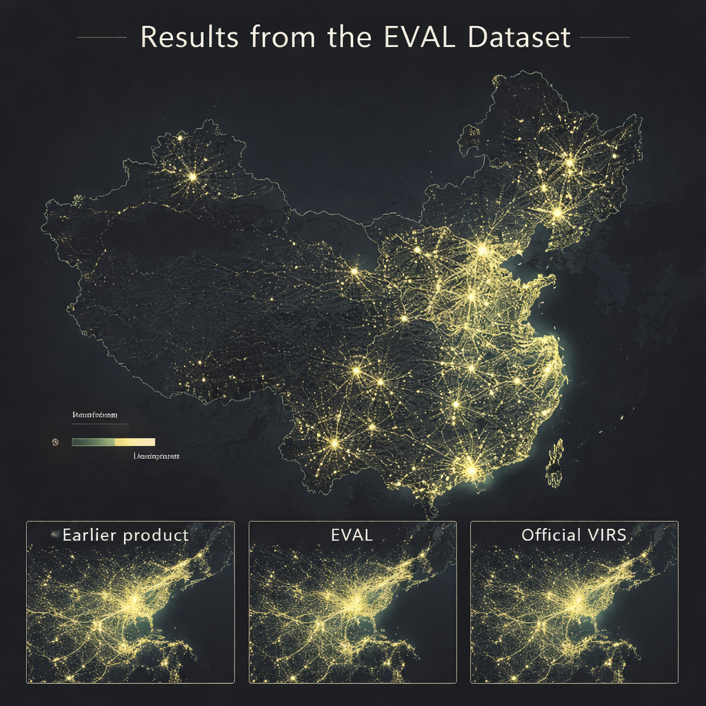
To check whether this new approach works, the team tested their reconstructions in 2012, a year when both the old and new satellite systems overlapped. They compared EVAL against two leading global products that also try to turn older data into VIIRS-like images. Across several image-quality measures, EVAL consistently matched the real VIIRS observations more closely, both pixel by pixel and when adding up light over nearly 3,000 counties. The new dataset not only avoids the common problem of underestimating brightness in downtowns and industrial zones, it also does a better job recovering the gradual dimming from city centers to suburbs and smaller towns. In rural areas, EVAL captures long, thin traces of highways and scattered villages that previous products either missed or over-smoothed.
Following China’s urban boom through time
Because EVAL stretches back to 1986 at a consistent resolution of about 500 meters, it gives a moving picture of China’s transformation from small urban cores to vast metropolitan clusters. The authors show time slices over major regions such as Beijing–Tianjin, Shanghai, Chengdu, and the Guangdong–Hong Kong–Macao Greater Bay Area. Early images reveal compact pockets of light; later years show those pockets brightening, spreading, and eventually merging into large, multi-centered agglomerations linked by brightly lit transport corridors. When the researchers compare provincial totals of nighttime light with official statistics for population and gross domestic product, they find very strong correlations—often above 0.95—over multiple decades, suggesting that the glowing maps track economic growth and human activity reliably.
A new backbone for studying our lit-up world
For non-specialists, the central message is straightforward: this work turns three decades of patchy, inconsistent nighttime satellite images into one clean, VIIRS-like movie of China’s lights from 1986 to the present. By better capturing both how bright and how finely structured those lights are, EVAL offers a powerful tool for studying urbanization, inequality, energy access, carbon emissions, and environmental impacts linked to human presence. In practical terms, it means that the changing pattern of lights you can see from space now lines up much more closely with the changes happening on the ground.
Citation: Tian, Y., Cheng, K.M., Zhang, Z. et al. An Extended VIIRS-like Artificial Nighttime Light Data Reconstruction (1986–2024). Sci Data 13, 233 (2026). https://doi.org/10.1038/s41597-026-06549-0
Keywords: nighttime lights, urbanization, remote sensing, China, deep learning