Clear Sky Science · en
Human-induced climate change amplification on storm dynamics in Valencia’s 2024 catastrophic flash flood
When Rare Rainstorms Turn Deadly
In late October 2024, the Spanish region of Valencia suffered a catastrophic flash flood: in just 16 hours, more rain fell than usually arrives in an entire year, killing around 230 people and causing massive damage. This article asks a direct and very human question: how much did human‑driven climate change load the dice for this disaster? By reconstructing the storm in two different worlds — one like today’s and one resembling the pre‑industrial climate — the authors show how warming oceans and moister air have already made such events more intense and more dangerous.
A Record‑Breaking Storm Over Valencia
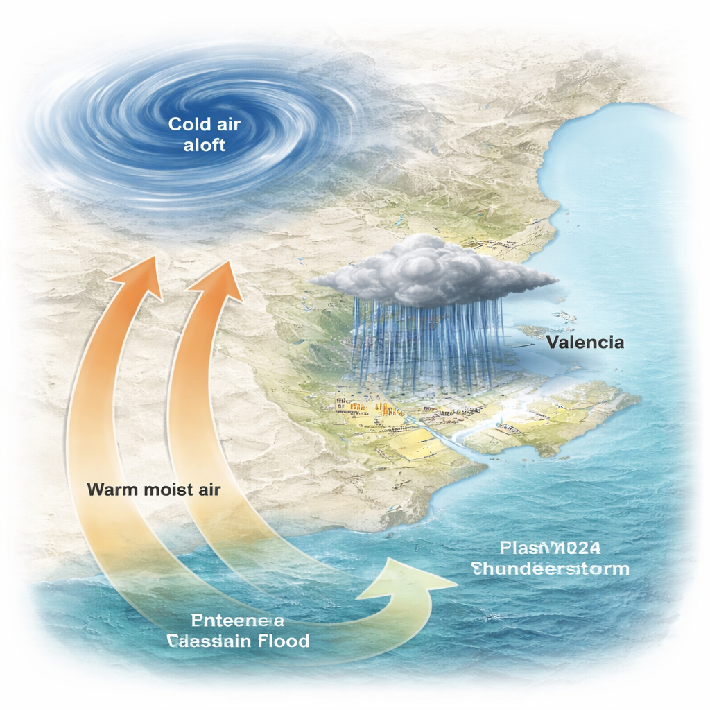
On October 29, 2024, a powerful weather pattern set the stage over eastern Spain. A pool of cold air high in the atmosphere, known as a “cut‑off low,” sat over the Iberian Peninsula while warm, humid air flowed in from the Mediterranean Sea and the subtropical Atlantic. Where these air masses met above Valencia, they created a nearly stationary complex of thunderstorms that poured out extreme rainfall. At the official station in Turís, 771.8 millimeters of rain fell in 16 hours, and Spain’s national record for one‑hour rainfall — 184.6 millimeters — was broken. Rivers and ravines responded almost instantly, producing violent flash floods, 11 tornadoes, large hail, and widespread destruction in the southern metropolitan area.
Replaying the Storm in Two Different Climates
To find out how much human‑caused warming intensified this event, the researchers used a high‑resolution weather model that can explicitly simulate individual thunderstorms on a grid of about 1 kilometer. They ran two main types of simulations. The first reproduced the storm in the real, present‑day climate, using modern observations as starting conditions. The second set of runs kept the same overall weather pattern but “cooled” the background climate to resemble the late 1800s, before greenhouse gases had risen substantially. This was done with a technique called a pseudo‑global warming approach, which systematically reduced air temperatures and moisture in line with historical climate model data, while leaving the large‑scale weather pattern itself intact.
Heavier Downpours Over a Larger Area
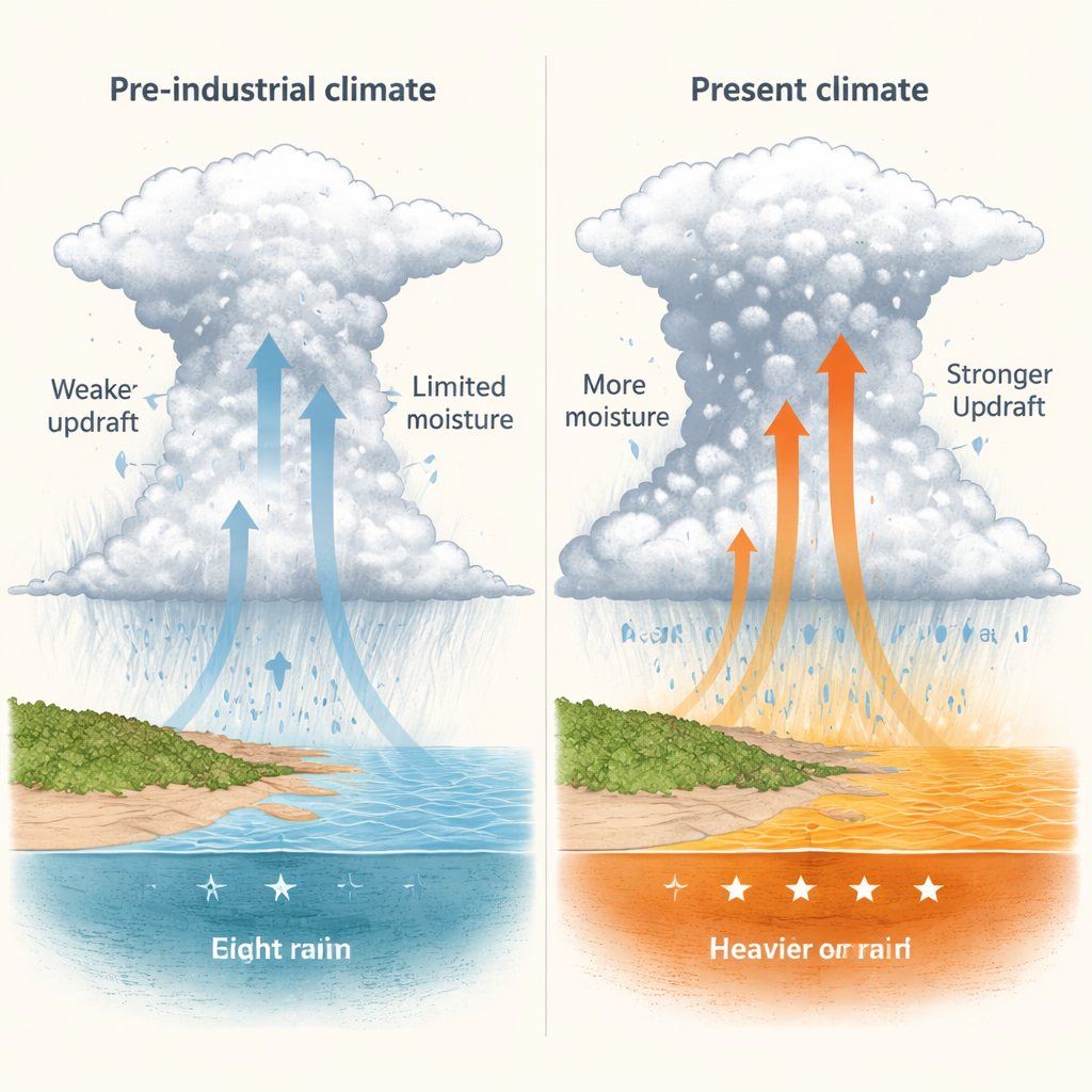
When they compared the two worlds, the differences were striking. In the present climate, hourly rainfall peaks were about 20 percent higher for each degree of warming than in the cooler world, outpacing the textbook 7 percent per degree increase expected simply from warmer air holding more moisture. Six‑hour rainfall totals in the simulated storm core were much greater, and extreme rainfall covered a wider region. The area with more than 180 millimeters of rain — the threshold for Spain’s highest weather warning — was about 55 percent larger in the present‑day simulations. Within the Júcar River basin, which drains much of the affected area, the total volume of rain increased by roughly 19 percent compared with the pre‑industrial‑like runs.
Why a Warmer World Makes Storms Meaner
The study reveals how subtle changes in the atmosphere translated into dramatically stronger floods. Warmer sea surfaces in the western Mediterranean and nearby Atlantic loaded the lower atmosphere with extra moisture, increasing the total “precipitable water” in the air by about 12 percent. This also raised the amount of energy available to fuel thunderstorms, so updrafts — the rising currents that build storm clouds — became stronger and more widespread. Inside the clouds, there was more graupel (soft hail) and a deeper warm layer where raindrops can grow efficiently before freezing. Together, these factors increased the “precipitation efficiency” of the storm by more than 10 percent, meaning a greater fraction of the available water vapor was converted into rain reaching the ground.
What This Means for Future Flood Risk
To a non‑specialist, the takeaway is clear and sobering: climate change did not create the Valencia storm, but it made the downpours heavier, the flooded area larger, and the impacts more severe. By showing that today’s warming has already pushed rainfall intensities beyond simple thermodynamic expectations, the study suggests that future flash‑flood risk in the Western Mediterranean is likely to grow as the planet continues to heat up. The authors argue that this demands faster investment in adaptation — from improved warning systems and drainage to smarter urban planning — because rare, high‑impact storms like Valencia 2024 are becoming more dangerous in our warmer world.
Citation: Calvo-Sancho, C., Díaz-Fernández, J., González-Alemán, J.J. et al. Human-induced climate change amplification on storm dynamics in Valencia’s 2024 catastrophic flash flood. Nat Commun 17, 1492 (2026). https://doi.org/10.1038/s41467-026-68929-9
Keywords: extreme rainfall, flash floods, climate change, Mediterranean storms, Valencia 2024