Clear Sky Science · en
Net widening of Southern California beaches
Why Southern California’s Beaches Are Bucking the Erosion Story
Coastal communities around the world worry that beaches are shrinking because dams block river sand, cities pave over watersheds, and seas are rising. This study delivers a surprising twist: despite intense urbanization and many large dams, Southern California’s beaches have actually grown wider overall during the past four decades. By combining long records from satellites with new analysis techniques, the authors show how sand still reaches the coast, where it piles up, and why some beaches thrive while others nearby are in trouble.
Looking at the Coast from Space
To move beyond scattered surveys and old maps, the researchers turned to satellite images taken regularly since the 1980s. Using a method called CoastSat, they automatically traced the boundary between land and water along 1,700 kilometers of the California shoreline, then corrected those shorelines for tides and seasonal cycles. This allowed them to build year-by-year records of how wide each sandy beach was, and how its position shifted over time. They grouped beaches into segments and larger "littoral cells"—coastal reaches where sand mostly circulates locally—so they could compare broad regional patterns with local hotspots.
A Surprising Pattern of Net Growth
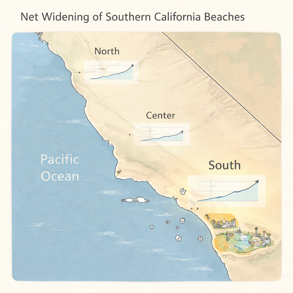
Globally, the loss of river-borne sand due to dams is a leading cause of beach erosion. Southern California fits that picture on paper: its rivers have been heavily dammed, and earlier work suggested chronic beach retreat. Yet the new satellite-based analysis tells a different story. Between 1984 and 2024, Southern California beaches gained about 2.3 million square meters of area—roughly a 10 percent increase in total beach size—equivalent to an average seaward shift of more than seven meters. Northern California showed only a weak growth trend, while Central California stayed roughly steady. The difference is not a smooth, gentle expansion: it reflects a patchwork of beaches, some widening rapidly and others shrinking, with human actions and coastal geography deciding which is which.
Where Sand Gathers and Where It Runs Short
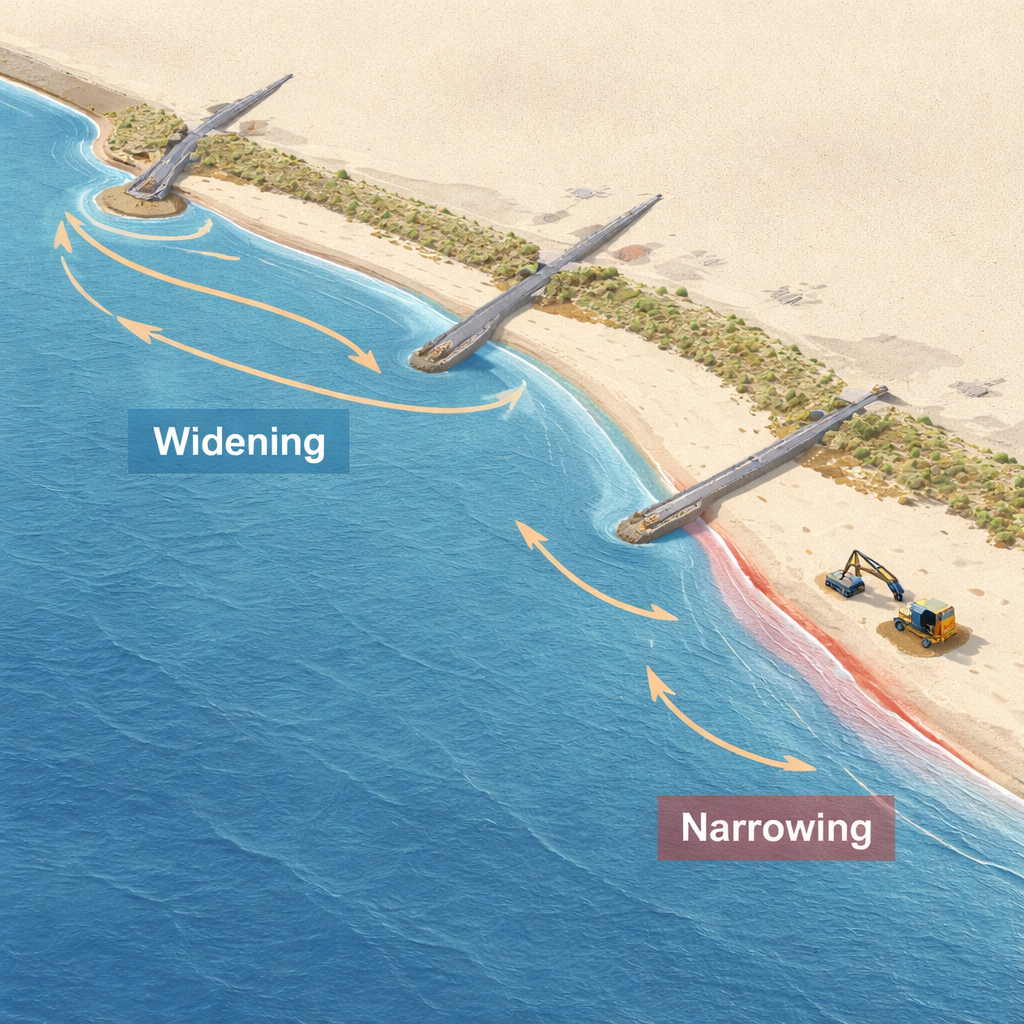
Zooming in, the study finds that nearly half of Southern California’s shoreline length shows statistically significant widening, while about one-third is clearly narrowing. A small number of stretches—such as McGrath State Beach near the Santa Clara River, Huntington Beach in the San Pedro littoral cell, and the beaches around Santa Monica and Venice—account for most of the net gain. These sites tend to be already wide beaches that act like sand traps. Rivers, harbor dredging and bypassing, and deliberate beach nourishment all feed extra sand into the system. Longshore currents then push this sand along the coast until it is blocked by features like harbors, jetties, and breakwaters, or by natural bends in the shoreline. Where the moving sand converges, beaches steadily grow; where it diverges, beaches thin and infrastructure becomes more exposed.
Storm Waves Versus Long-Term Sand Supply
The coast does not simply march forward year after year. Big-wave winters, such as those linked to strong El Niño events, carve beaches back, while calmer years allow them to rebuild. By comparing annual wave power with beach area, the authors show that storms explain much of the year-to-year ups and downs. However, they do not account for the long-term trend. Even after removing the effect of changing wave energy, most Southern California littoral cells still show strong net growth. Sediment budget calculations—adding up sand delivered by rivers, construction projects, dredging, and harbor bypassing—confirm that millions of cubic meters of sand have accumulated in certain sections of the coast, more than enough to explain the persistent widening seen from space.
What This Means for Coastal Communities
For residents, visitors, and planners, the message is both hopeful and challenging. The region as a whole does not lack sand; instead, sand is piling up in the wrong places. Human-built structures and natural current patterns funnel sediment into a few “winner” beaches while leaving others starved. This means that solving local erosion problems will depend less on finding entirely new sand sources and more on smarter redistribution—such as improving harbor bypass programs, rethinking where nourishment is placed, and, in some cases, revisiting dam and watershed management. The study shows that with modern satellite tools, it is possible to track these trends in detail, offering a powerful new way to design coastal policies that keep beaches healthy and communities safer in a changing climate.
Citation: Warrick, J.A., Vos, K., Buscombe, D.D. et al. Net widening of Southern California beaches. Nat Commun 17, 1705 (2026). https://doi.org/10.1038/s41467-026-68880-9
Keywords: beach erosion, coastal sediment, satellite shoreline monitoring, Southern California coast, longshore sand transport