Clear Sky Science · en
Record-breaking emergence of upstream-downstream zonal-consistent variation in the Eurasian jet axis
Why the high-altitude winds matter to everyday life
The weather disasters we feel on the ground—heatwaves, floods, and droughts—are strongly shaped by a powerful river of air that races high above our heads. This study shows that over the last few decades, a key jet stream over Eurasia has begun to behave in a far more synchronized way from west to east. That newfound coordination, the authors argue, helps explain why huge regions across Europe, Asia, and even North America are increasingly sharing the same extreme heat and dry spells at the same time.
A giant wind river over Eurasia
In summer, a fast west-to-east band of winds sits about 10 kilometers above Eurasia, from the Atlantic across Europe and Asia to the Pacific. Traditionally, scientists have focused on how this "wind river" wiggles north and south or weakens and strengthens in particular spots. Here, the authors introduce a different idea: how tightly linked the jet is along its length. They measure how often the jet’s western part over Europe and its eastern part over East Asia speed up or slow down together—a feature they call upstream–downstream zonal consistency, or UDZC. When UDZC is high, the jet strengthens or weakens in a broadly unified way right across the continent.
A sudden shift toward lockstep behavior
By analyzing many independent weather reanalysis data sets going back more than a century, the researchers find that strong UDZC used to be rare. For most of the 20th century, the jet’s western and eastern segments behaved almost independently. Since the late 1970s, and especially after the late 1990s, that has changed sharply: the two segments now rise and fall together, with their shared variations jumping from less than 10% to more than 60%. This marks a new dominant pattern in the upper-level winds. Instead of the jet mainly sliding north or south, the whole band tends to strengthen or weaken together, flanked by weaker polar winds to the north and altered tropical winds to the south. 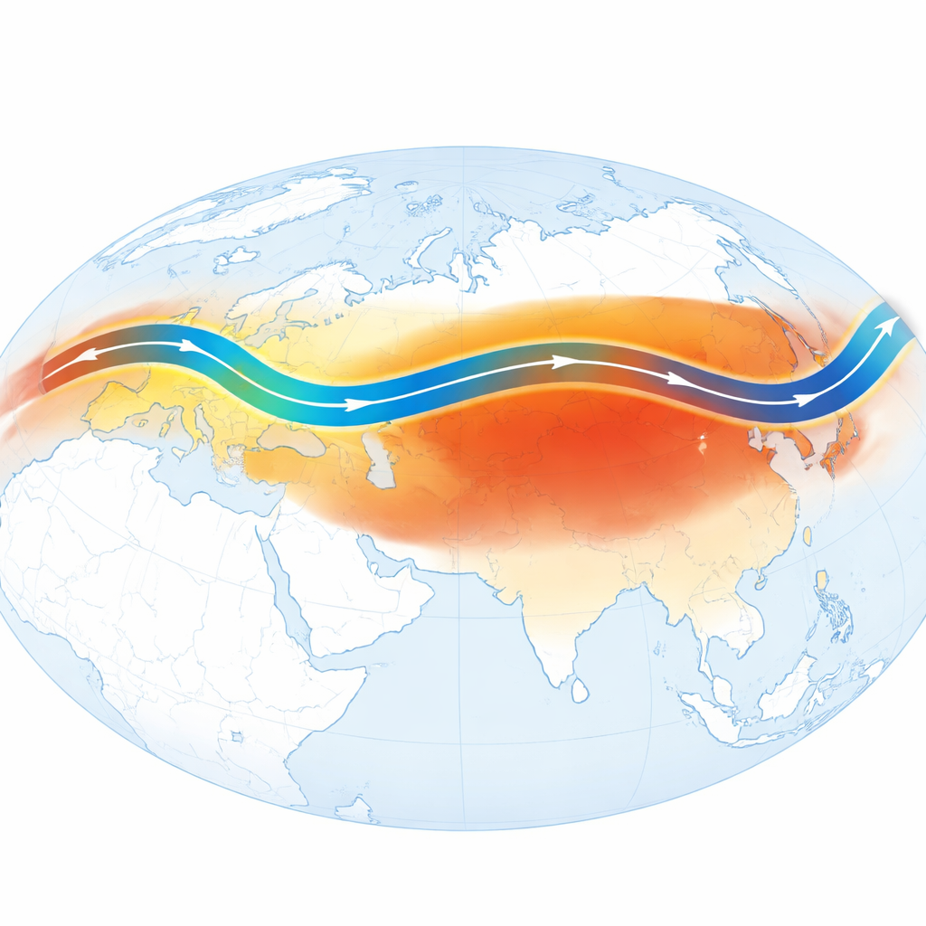
From high winds to heat domes and drought
These coordinated wind changes reshape weather on the ground. A stronger, more continuous jet behaves like a stiffer barrier between warm, moist air and cooler, drier air, sharpening temperature and moisture contrasts north and south of the jet. The study shows that in the recent high-UDZC era, this has produced large, continent-spanning patterns of extremes: more heatwaves and drought in both high and low latitudes of Eurasia, with relatively fewer in some midlatitude zones. Over East Asia, the powerful jet reinforces major high-pressure systems over the Tibetan Plateau and the western North Pacific. Those systems encourage sinking, dry air and redirect moisture, helping create "heat dome" conditions and compound hot–dry events like those seen in the record summer of 2022.
A globe-circling wave train
The jet stream can also act as a waveguide, channeling slow-moving bends in the flow around much of the Northern Hemisphere. The authors identify a particular six-crest wave pattern, which they call a circumglobal Silk Road teleconnection. This pattern starts over the eastern North Atlantic, arches across Eurasia, and reaches North America. Along its path, it links high pressure, heatwaves, and drought in western Europe with similar hot, dry conditions in western North America, while bringing extra rain and fewer heatwaves to some lower-latitude areas downstream. The triggering seems tied to patches of unusually warm sea surface in the Northeast Atlantic that develop months earlier and then interact with the jet as summer arrives. 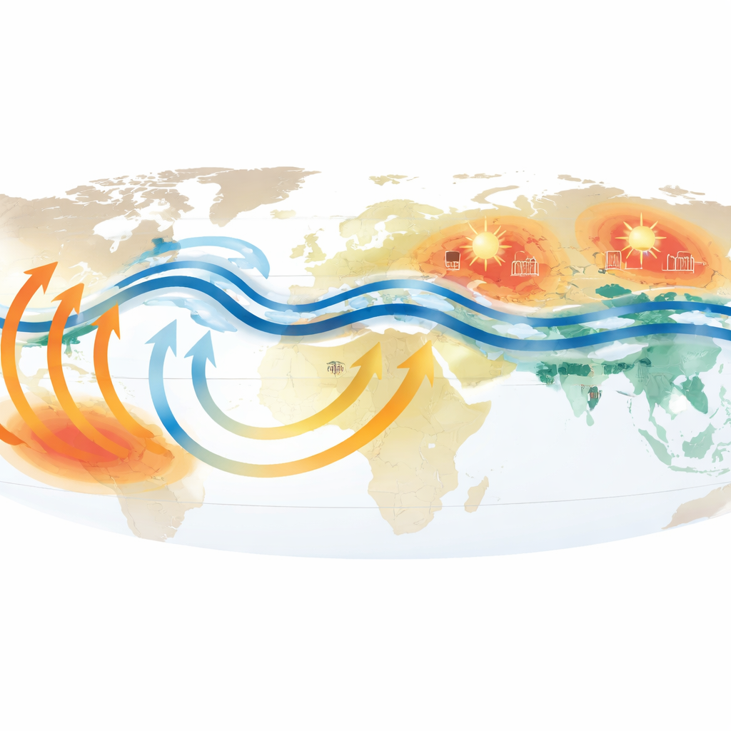
What climate models say about the future
The team then checks whether leading climate models reproduce this new lockstep behavior. Most models struggle: they tend to simulate only weak coupling along the Eurasian jet and fail to capture the recent rapid surge in UDZC. A subset of simulations from one model family comes closer, hinting that the observed trend is partly driven by human-caused warming but is still underestimated. Across the broader model set, those versions that produce stronger future warming over northern midlatitudes also tend to produce stronger future UDZC. This points to an important message: as the land and nearby oceans of the Northern Hemisphere continue to warm, the Eurasian jet may become even more coherent along its length.
Why this matters for people and planning
For non-specialists, the key takeaway is that it is not just how strong the jet stream is, or where it sits, but how evenly it behaves from one end of Eurasia to the other. The recent rise in this "all-together" mode helps explain why extreme heat and drought increasingly hit multiple far-flung regions at once—from Europe to China to North America. Because many current climate models do not yet capture this behavior well, standard projections may be underestimating the risk of simultaneous harvest failures, stressed power grids, and widespread health impacts. Recognizing and improving our understanding of this synchronized jet pattern is therefore crucial for preparing societies and economies for a future with more connected climate extremes.
Citation: Lin, L., Hu, C., Chen, D. et al. Record-breaking emergence of upstream-downstream zonal-consistent variation in the Eurasian jet axis. Nat Commun 17, 2671 (2026). https://doi.org/10.1038/s41467-026-68772-y
Keywords: jet stream, Eurasia, heatwaves, teleconnections, climate change