Clear Sky Science · en
Homogenization of Northern Belgian landscapes through centuries of reclamation, agricultural transition, and urbanization
Why our changing countryside matters
Across northern Belgium, the patchwork of fields, forests, wetlands and villages that once differed sharply from place to place now looks surprisingly similar. This study asks how that happened over nearly 250 years, and what it means for nature, farming and daily life. Using artificial intelligence to read old maps, the authors trace how human actions—draining land, shifting farm practices and building towns—gradually erased many of the contrasts between landscapes that earlier generations took for granted.
Reading history from old maps
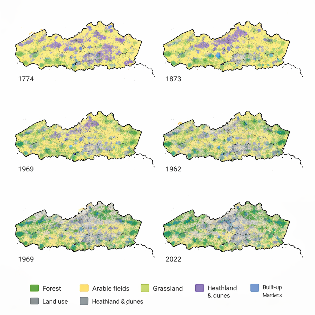
To uncover this long story, the researchers turned to detailed historical maps from 1774, 1873 and 1969, together with a modern land-use map from 2022. They used a type of “GeoAI,” or geographic artificial intelligence, to automatically recognize different types of land across 13,800 square kilometers of northern Belgium. Nine main categories were mapped at a fine 10-by-10-meter grid: arable fields, grasslands, forests, orchards, heath and dunes, marshes, intertidal zones, open water, and built-up areas with gardens. The results were checked carefully against the original maps and reached high accuracy, allowing the team to reconstruct how land use has shifted across both time and soil types.
From wild commons to working farmland
The first major phase of change ran from 1774 to 1873, when population growth pushed people to reclaim land. In 1774, about a quarter of northern Belgium was covered by long‑established forests, heathland, marshes and tidal flats—areas often used as common land for grazing animals, cutting peat or gathering wood. Within a century, these natural and semi‑natural areas had been cut roughly in half. Heath and dunes on sandy soils were plowed up or planted with conifer forests, while marshes and tidal flats were drained or diked. The share of arable fields grew and spread onto the most fertile soils, strengthening the link between what the land was used for and the type of soil beneath it.
Global markets reshape the fields
The second phase, from 1873 to 1969, was driven by globalization. Cheap grain imported from overseas made it less profitable to grow cereals locally, but rising demand for meat and dairy encouraged farmers to keep more livestock. Grasslands for grazing and haymaking doubled in area, spreading far beyond river valleys and coastal polders. Orchards expanded, especially on rich silt‑loam soils in the southeast, as specialized fruit growing took off. At the same time, the dominance of arable fields declined, and different land uses started to appear side by side on the same soil types. Statistical measures in the study show that the tight match between particular soils and particular land uses weakened during this period, and the landscape became more finely mixed.
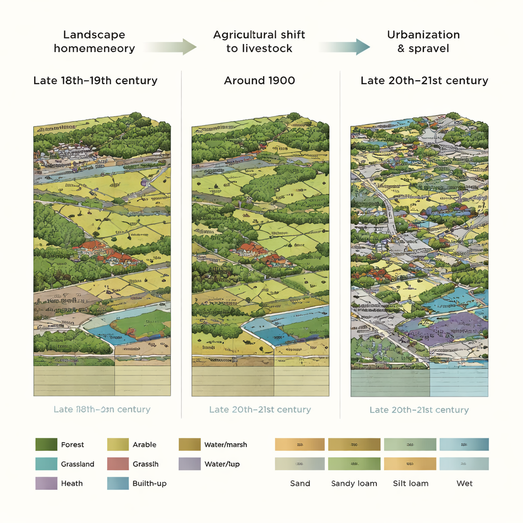
Cities sprawl and landscapes blend
The third phase, from 1969 to 2022, is marked by urbanization. Built‑up areas with gardens expanded from about one‑sixth to nearly one‑third of the region, outpacing population growth and signaling extensive urban sprawl. New housing and infrastructure did not avoid fertile or flood‑prone soils; instead, development spread fairly evenly across sand, loam, polders and river valleys. Arable land and grasslands both shrank in area, and what remained became more fragmented, broken into smaller pieces by roads and buildings. Only forests gained modest ground overall, but many of the oldest, most natural woodlands had already been lost much earlier. Measures of how mixed the land uses are reveal that large swaths of northern Belgium shifted from relatively uniform zones—such as wide arable plateaus or open heathlands—to a dense checkerboard of fields, houses and small habitat remnants.
What a homogenized landscape means for us
Taken together, these three waves—reclamation, agricultural transition and urbanization—have turned a region of clearly distinct landscapes into one where land uses are heavily interwoven and much more alike from place to place. This homogenization has consequences: it helps explain declines in biodiversity, the loss of historic cultural landscapes, and growing exposure to flood risk as building spreads onto vulnerable soils. By showing that GeoAI can convert centuries‑old maps into detailed, region‑wide land‑use histories, the study also offers a powerful new tool. Planners, conservationists and communities can now better see how today’s environment reflects past decisions, and use that understanding to protect remaining natural areas, restore key habitats and steer future development more wisely.
Citation: De Keersmaeker, L., Roggemans, P., Poelmans, L. et al. Homogenization of Northern Belgian landscapes through centuries of reclamation, agricultural transition, and urbanization. Nat Commun 17, 1906 (2026). https://doi.org/10.1038/s41467-026-68594-y
Keywords: land-use change, urbanization, historical maps, landscape homogenization, GeoAI