Clear Sky Science · en
Global alluvial channel patterns
Rivers That Shape Our World
Rivers don’t just carry water; they sculpt continents, feed cities, nurture wetlands, and record Earth’s history in their channels and floodplains. This study asks a deceptively simple question with big implications: what kinds of river channels actually dominate our planet? Using decades of satellite images and new global datasets, the authors reveal that a surprisingly intricate form of river, called anabranching, is far more common than the familiar single, winding river we usually picture.
A Hidden Majority in Plain Sight
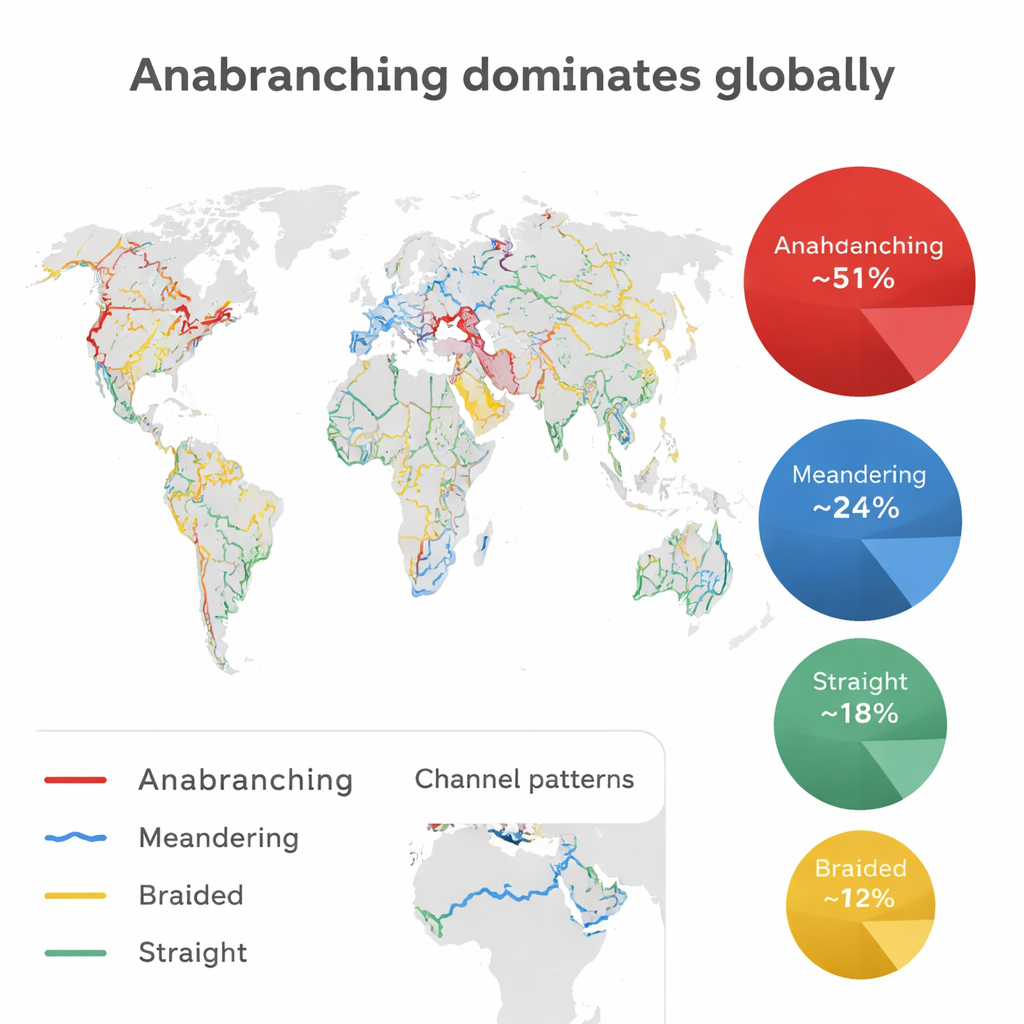
For decades, textbooks have grouped rivers into four basic shapes: straight, meandering, braided, and anastomosing. Anabranching rivers—where flow splits into several stable branches around vegetated islands—were usually treated as rare exceptions. By systematically mapping wide, sediment-rich (“alluvial”) river reaches around the globe, this study overturns that view. The authors find that anabranching channels make up about half (51%) of the total length of alluvial river reaches they analyzed, more than meandering (24%), straight (18%), and braided (7%) channels combined. This dominance holds not only in lowland plains but also in many mountain valleys and along coasts, meaning multi-channel rivers are a central, not marginal, part of Earth’s river network.
Reading Rivers from Space
To reach these conclusions, the team built a new global alluvial channel pattern (GACP) dataset. They combined high-resolution water maps from Landsat satellites, spanning 1984 to 2020, with a detailed global river network that splits rivers into segments about 10 kilometers long. For each segment, they used an algorithm to decide whether the channel is single or multi-threaded, how winding it is, and whether the mid-channel features are stable islands or shifting bars. They also excluded bedrock gorges, artificial canals, lakes, and very narrow or extremely dry channels where patterns would be hard to classify. Validation against thousands of high-resolution Google Earth images showed an accuracy above 88%, giving confidence that the broad global picture is reliable.
Patterns Across Continents and Climates
When the authors broke down results by landscape and climate, the same theme emerged: anabranching is widespread. In non-mountainous regions, which host about 71% of the mapped river length, anabranching still accounts for half of all channels, outpacing meandering and braided rivers on every continent except Oceania. In Africa, these multi-channel systems cover more than half of the non-mountainous river length, dominating major basins like the Niger, Congo, and Nile. Even in mountains—where steep, rocky valleys often limit floodplain development—anabranching channels make up roughly half of the alluvial reaches identified. Coastal river segments, including many deltas, are similarly dominated by anabranching patterns, although heavy human engineering has created long straightened reaches in parts of Europe.
Why Rivers Split and Wander
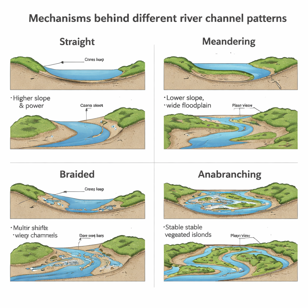
Rivers do not choose their shape at random. The study examined how channel patterns relate to slope (how fast rivers drop in elevation), stream power (a measure of flow energy), the relative width of floodplains, and the amount of fine sediment carried in suspension. Braided rivers, with their many bare, shifting bars, tend to occupy steeper, more energetic settings. Meandering rivers typically form on gentler slopes with wide floodplains where the single channel can migrate sideways over time. Anabranching rivers, however, span a broad range of conditions: from cold periglacial regions with higher slopes and strong seasonal flows, to lowland tropics with vast floodplains and abundant vegetation. Their key trait is the presence of relatively stable, often vegetated islands that keep the separate branches hydraulically distinct even during high flows. Because these systems are so diverse, no simple rule cleanly separates all channel types, but the data show that anabranching thrives wherever floodplains and vegetation can help stabilize multiple branches.
Rethinking Rivers and Their Future
By revealing that anabranching rivers dominate much of the world’s alluvial channel length, this work challenges long-standing river classifications and the way scientists interpret ancient river deposits. Many rock layers once assumed to record only meandering or braided rivers may in fact preserve overlooked multi-channel systems. The findings also matter for biodiversity, water quality, and climate, because anabranching rivers host broad, complex floodplains that trap sediment and organic carbon and provide resilient habitats. As climate warming accelerates erosion in cold regions and alters river flows, channel patterns may shift—perhaps toward more braiding in some periglacial areas and faster changes in multi-channel systems. Understanding that Earth’s rivers are more often branching webs than single blue lines is essential for planning river conservation, restoration, and management in a rapidly changing world.
Citation: Luo, Q., Park, E., Latrubesse, E.M. et al. Global alluvial channel patterns. Nat Commun 17, 1950 (2026). https://doi.org/10.1038/s41467-026-68569-z
Keywords: river morphology, anabranching rivers, fluvial geomorphology, remote sensing, global river patterns