Clear Sky Science · en
In situ characteristics and patterns of settlement spatial differentiation along the Grand Canal’s Tianjin Section
Ancient Waterway, Living Villages
The Grand Canal is not just a feat of ancient engineering; it is a living backbone that has shaped where people in northern China live, work, and celebrate their traditions. This study looks closely at hundreds of villages along the Tianjin stretch of the canal to answer a deceptively simple question: why are these settlements where they are, and how are they different from one another? The answers matter today, as rapid urban growth and tourism threaten to blur or erase the distinct character of canal-side communities.
Tracing a Historic Lifeline
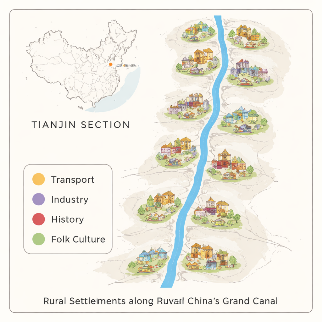
The Tianjin Section of the Grand Canal, running nearly 190 kilometers through the North China Plain, has long been a gateway between river and sea and a conduit between north and south. For almost two millennia, grain shipments, soldiers, merchants, and ideas moved along this waterway. As a result, more than 700 towns and villages sprang up on its banks, from compact river hamlets to strategic garrison posts. Today, many still exist, especially in the suburban areas of Jinghai and Wuqing, but their historic layouts and local customs face mounting pressure from redevelopment and changing lifestyles.
Redrawing the Map of Canal Villages
Earlier research often focused only on famous canal towns or on settlements within an arbitrary short distance of the water, which missed much of the broader canal landscape. This study takes a different approach. Using historical records of how far people could walk in a day in imperial times, the authors draw an initial band about 15 traditional li—roughly 9 kilometers—on each side of the canal. Within this zone they identify existing villages that still retain their traditional form. They then overlay detailed digital maps of both tangible heritage (such as ancient city sites, temples, stone inscriptions, and old hydraulic works) and intangible heritage (such as folk festivals, martial arts, and storytelling) to include a small number of important canal-related settlements that fall just outside the walking band.
Patterns in Fields, Water, and Villages
With this refined boundary, the researchers end up with 749 canal-related settlements. They analyze satellite-based land-use data using landscape-ecology software to see how these villages fit into their surroundings. The countryside along the canal turns out to be dominated by dry farmland dotted with many small, fragmented village patches, threaded by rivers, ponds, and reservoirs. The mix of land types is quite diverse, but not evenly spread: some uses, such as cropland and settlement land, strongly dominate, while others appear in smaller, scattered patches. Villages themselves tend to cluster rather than sit alone, but the ecological connection between natural habitats—important for wildlife and water quality—is relatively weak.
Four Ways a Canal Shapes Villages
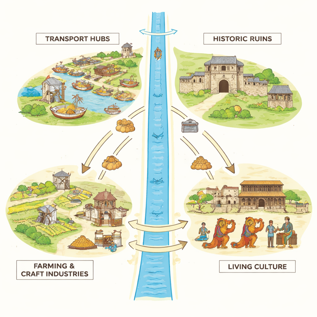
The authors then classify each settlement into one main local “identity,” supported by fieldwork and scoring from a panel of experts. Four broad types emerge. Transport-based villages grew around the work of keeping boats and grain moving—at docks and ferries, diversion channels, warehouses, and military posts. Industry-based settlements built livelihoods on canal-linked trades such as vegetable farming, fishing, shipping services, and handicrafts. History-based villages are anchored by ancient city ruins, old courtyard houses, carved tombstones, or ties to notable historical figures. Finally, folk-culture-based communities are best known today for their traditional crafts, performances, and oral legends. Industry-based villages are by far the most common, especially vegetable-growing and craft-making communities, while purely folk-culture-based settlements are relatively few but culturally rich.
Hidden Order in a Patchwork Landscape
Mapping these types reveals that the villages are not randomly scattered. Military garrison settlements and ancient city sites line up in a pronounced north–south band, echoing old defense lines and administrative centers. Ferry and dock villages form a belt of clusters at key crossing points. Fishing and vegetable-growing communities form multi-core groupings in especially fertile or well-watered stretches. Craft villages appear in patchy clusters near good transport access. Folk performances and legends, by contrast, are sprinkled more loosely but often overlap with places of historic or industrial importance, showing how everyday culture has grown out of work, war, and water management along the canal.
Why These Findings Matter Today
Seen through this lens, the Tianjin Section of the Grand Canal is not just a string of heritage spots but an interconnected system of landscapes and lifeways shaped by transport, industry, history, and folk culture all at once. The study argues that protecting canal villages means first understanding these in-place patterns—where the boundaries really are, which clusters of settlements share a function or story, and how natural features and human choices have interacted over centuries. For planners and conservationists, this richer picture can guide which areas to preserve as coherent cultural corridors, how to support local economies without erasing character, and how to keep the canal’s living heritage—from martial arts schools to stilt-dance troupes—rooted in the communities that created it.
Citation: Zhao, Y., Bian, G. In situ characteristics and patterns of settlement spatial differentiation along the Grand Canal’s Tianjin Section. npj Herit. Sci. 14, 128 (2026). https://doi.org/10.1038/s40494-026-02394-x
Keywords: Grand Canal, rural settlements, Tianjin, cultural heritage, landscape patterns