Clear Sky Science · en
Administrative power as a visible hand in the spatial distribution patterns of Chinese Weilongwu houses
Ancient Houses and Invisible Borders
In the mountains of southern China, thousands of traditional Hakka courtyard houses called Weilongwu form a quiet record of how people moved, settled, and built their lives. This study shows that these homes are not scattered at random: their locations reveal how government boundaries and power have shaped culture over centuries. By blending satellite imagery, artificial intelligence, and historical maps, the authors turn a vanished world of migration and local life into patterns we can see and measure today. 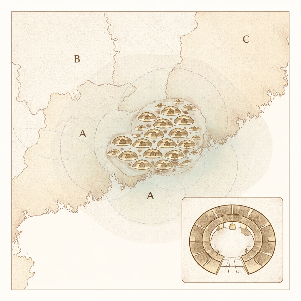
What Makes These Houses Special
Weilongwu are distinctive Hakka residences with a semicircular "tail" wrapping around an inner courtyard, a form that stands out clearly from the sky. The Hakka, whose name means "guest people," are Han Chinese who repeatedly migrated from China’s central plains into the hilly borderlands of Guangdong, Fujian, and Jiangxi. Their houses carried deep meaning: they expressed family unity, protection, and a sense of belonging in often marginal lands. Because these homes were rebuilt and repaired over generations, their footprints on the landscape preserve a long history of where Hakka communities chose to live.
Reading the Landscape with AI
To turn this heritage into data, the researchers trained a modern object-detection system (YOLOv8) to spot Weilongwu automatically in high‑resolution satellite images. Focusing on a large border region where the three provinces meet, they sliced more than two million image tiles and taught the model to recognize the crescent-shaped back of the houses, even when structures were partially damaged. After validation, the system identified 5,698 Weilongwu with high accuracy. Each detection was converted into geographic coordinates, creating a detailed map of where these buildings survive today. 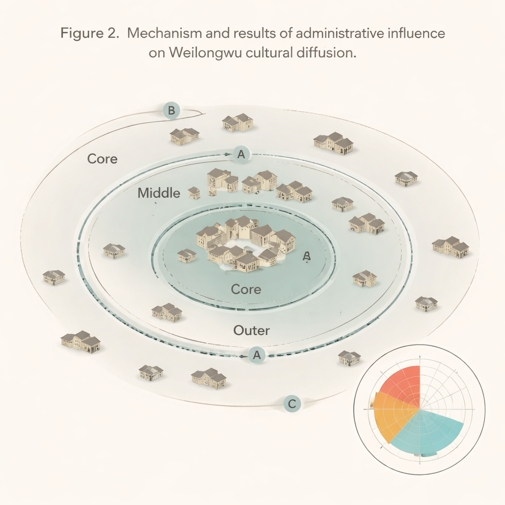
Finding Cultural Centers and Edges
With this map in hand, the authors asked two main questions: Where did this house style likely begin, and how far did it spread? Using statistical tools, they pinpointed a core cluster around Xingning and Meixian in northeastern Guangdong as the most probable birthplace. From there, the houses thin out in a stretched oval pattern, reaching roughly 280 kilometers at most. The team then overlaid historical administrative boundaries from the late Qing dynasty—provinces, prefectures, and counties—onto this cultural footprint. They found that Weilongwu rarely appear near the capitals of big provinces, but are dense around smaller prefectural and county seats, and especially in the hilly borderlands between regions.
How Power Shapes Cultural Spread
To explain this pattern, the authors introduced the ideas of "cultural primacy" and "cross‑boundary attenuation." Cultural primacy measures how strongly a style clusters around an administrative center: a high score means many Weilongwu near that town, a low score means they sit mostly in the countryside. Cross‑boundary attenuation describes how quickly the density of houses drops when one crosses a boundary line. The results show that mid‑level prefectural borders act like semi‑permeable membranes. Within a prefecture, the house style spreads relatively freely, often forming dense clusters near county towns. But when it reaches the edge of a prefecture or a province, the pattern changes sharply: densities fall, and only scattered "outpost" houses appear beyond. In contrast, the smallest county boundaries offer little resistance—the style flows across them more smoothly.
Balancing Local Culture and Central Rule
Closer reading of local histories suggests why. As Hakka migrants were resettled—sometimes by official policy—they were often steered toward marginal lands away from major cities but within the reach of county and prefectural power. Administrators had to keep order, collect taxes, and avoid letting any one local group grow too strong. Drawing and adjusting boundaries helped them balance control with tolerance. Over time, these lines guided where Hakka could build and cluster, turning Weilongwu into a culture of the edges rather than of the political cores.
What This Means for Understanding Culture
For non‑specialists, the key message is that culture does not simply drift wherever people go; it moves through channels shaped by institutions. In this case, the distinctive Hakka Weilongwu spread outward like ripples from a stone, but those ripples were bent and slowed by invisible walls of administrative geography. Provinces and prefectures neither fully blocked nor freely allowed this house form—they filtered it. The study shows how modern tools can uncover these hidden filters, offering a way to study other traditions, from languages to religious sites, and helping us see how government power and everyday culture continually shape each other across the landscape.
Citation: Li, G., Ye, ZY., Zhuo, XL. et al. Administrative power as a visible hand in the spatial distribution patterns of Chinese Weilongwu houses. npj Herit. Sci. 14, 88 (2026). https://doi.org/10.1038/s40494-026-02359-0
Keywords: Hakka architecture, cultural diffusion, administrative boundaries, Weilongwu houses, digital archaeology