Clear Sky Science · en
Complex network analysis of industrial heritage spatial protection and utilization: the Liuzhi mining case
Why Old Factories Still Matter
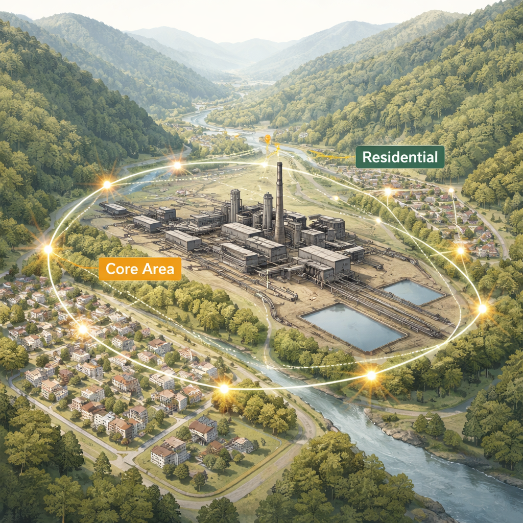
The Liuzhi Parcel Mines Coal Cleaning Plant in southwest China is more than an abandoned industrial site. It is a physical record of how a community worked, lived, and adapted to a rugged mountain landscape during a key chapter of China’s development. This study shows how tools usually used to analyze cities and the internet can also help us decide which parts of such sites to protect, how to open them to the public, and how to give them new life without erasing their history.
A Mountain Town Built Around a Mine
Liuzhi Coal Mine was built in the 1960s, when state-owned factories were expected to do everything: extract coal, process it, and also provide housing, schools, clinics, and daily services for workers. Because it sits in a deep, hilly valley rather than on flat land, the factory buildings, conveyor belts, rail lines, and homes grew together in a tightly fitted patchwork instead of in neat, separate zones. Many of these structures still stand today, making Liuzhi one of China’s better-preserved coal-cleaning complexes—and an ideal testing ground for new methods of industrial heritage planning.
Reading Space Like a Hidden Map
To understand how the site really works, the researchers treated it almost like a maze whose logic can be decoded. They first used “space syntax,” a method that measures how easy it is to move from one place to another and how well people can grasp the overall layout from local paths. The results showed that Liuzhi’s overall connectivity is weak: many internal roads end in dead-ends, and weaving through the plant is neither quick nor intuitive. The industrial production zone, where coal was cleaned and processed, is actually harder to reach internally than the surrounding residential areas, and the whole complex is only loosely tied to the natural terrain that shapes it.
From Buildings to Networks
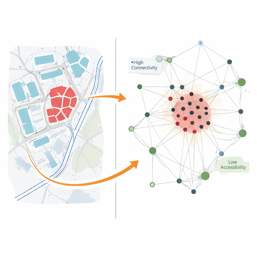
Next, the team looked at the pattern of buildings and open space, asking whether structures are clumped, scattered, or evenly spread. Using a measure called the “void ratio,” they found that, despite the difficult terrain, the blocks, roads, and open areas form a fairly uniform pattern, reflecting years of human planning and management. Then they went a step further and turned the site into a network diagram: every building and road became a node, and every doorway or road connection became a link. This complex network analysis revealed a classic “core–edge” structure. Clusters of production buildings form a dense, stable core with many connections, while housing and supporting facilities lie around the edges with weaker ties between them.
Finding the Most Valuable Pieces
By overlaying this network picture with information about each building’s age, architectural quality, location, and state of repair, the researchers could see which structures really hold the system together. Buildings with high historical value and good preservation tend to sit in the central, well-connected part of the network, acting like bones in the skeleton of the site. Residential buildings are more often “weak links” or break points in the network, meaning their removal would easily fracture connections. The study also identifies key “gateways” and “bridges” between clusters—ideal spots for visitor centers, exhibition halls, and other public functions—and shows that small changes in the road and pedestrian system could greatly improve how people move through the area.
Planning for Protection and New Life
Using these insights, the authors outline a two-level protection plan: a core zone where the most important industrial structures must be strictly preserved, and a general zone where some updating is allowed as long as the overall character and surrounding landscape remain intact. They propose two main visitor axes, several themed cultural zones, and seven major activity nodes devoted to industrial culture, education, creative industries, and services. When they test this new layout with the same analytical tools, accessibility improves noticeably while the site’s overall spatial pattern stays stable—suggesting that careful design can make the mine easier to use and understand without flattening its unique identity.
What This Means Beyond One Mine
For non-specialists, the main takeaway is that old industrial sites are not just piles of bricks and rusting machinery. They are complex systems whose hidden structure can be measured and used to guide smarter conservation. By combining spatial analysis, network theory, and on-the-ground planning, this study offers a replicable method that other cities and countries can adapt to their own factories, shipyards, and rail yards. In Liuzhi, these tools help turn a once-closed coal complex into a more legible, walkable place that honors its past while making room for new cultural, educational, and economic uses.
Citation: Fan, J., Zhang, B. & Yuan, H. Complex network analysis of industrial heritage spatial protection and utilization: the Liuzhi mining case. npj Herit. Sci. 14, 121 (2026). https://doi.org/10.1038/s40494-026-02350-9
Keywords: industrial heritage, coal mining, urban renewal, spatial networks, adaptive reuse