Clear Sky Science · en
Deformation and disease detection of Tulou based on multi-source 3D point cloud fusion
Why ancient earthen homes still matter today
Across the hills of southeastern China stand vast circular earthen houses called Tulou, some more than 300 years old. These communal buildings are still lived in, yet time, weather, and modern pressures are slowly wearing them down. The study summarized here shows how tools more often seen in high-tech factories and engineering labs—laser scanners, drones, and 3D modeling—can be used to give these fragile structures a detailed “health check,” helping conservators spot problems early and keep this cultural heritage standing for generations to come.
Life inside a giant earthen fortress
Tulou are monumental mud-and-wood dwellings built by Hakka communities in Fujian Province. From the outside, a Tulou like Jinjiang Tulou looks like a huge ring-shaped fortress of packed earth; inside, it is a vertical village, with stacked wooden rooms circling a shared courtyard. This design has sheltered families from bandits, storms, and earthquakes for centuries. But the same thick earthen walls and timber beams that make Tulou so distinctive are vulnerable to slow damage from rain, moisture creeping into the walls, and constant wind. Cracks, bulges, and decay may grow for years before anyone notices that the building’s shape is drifting out of line with what gravity and safety demand.
Turning a historic building into a precise 3D model
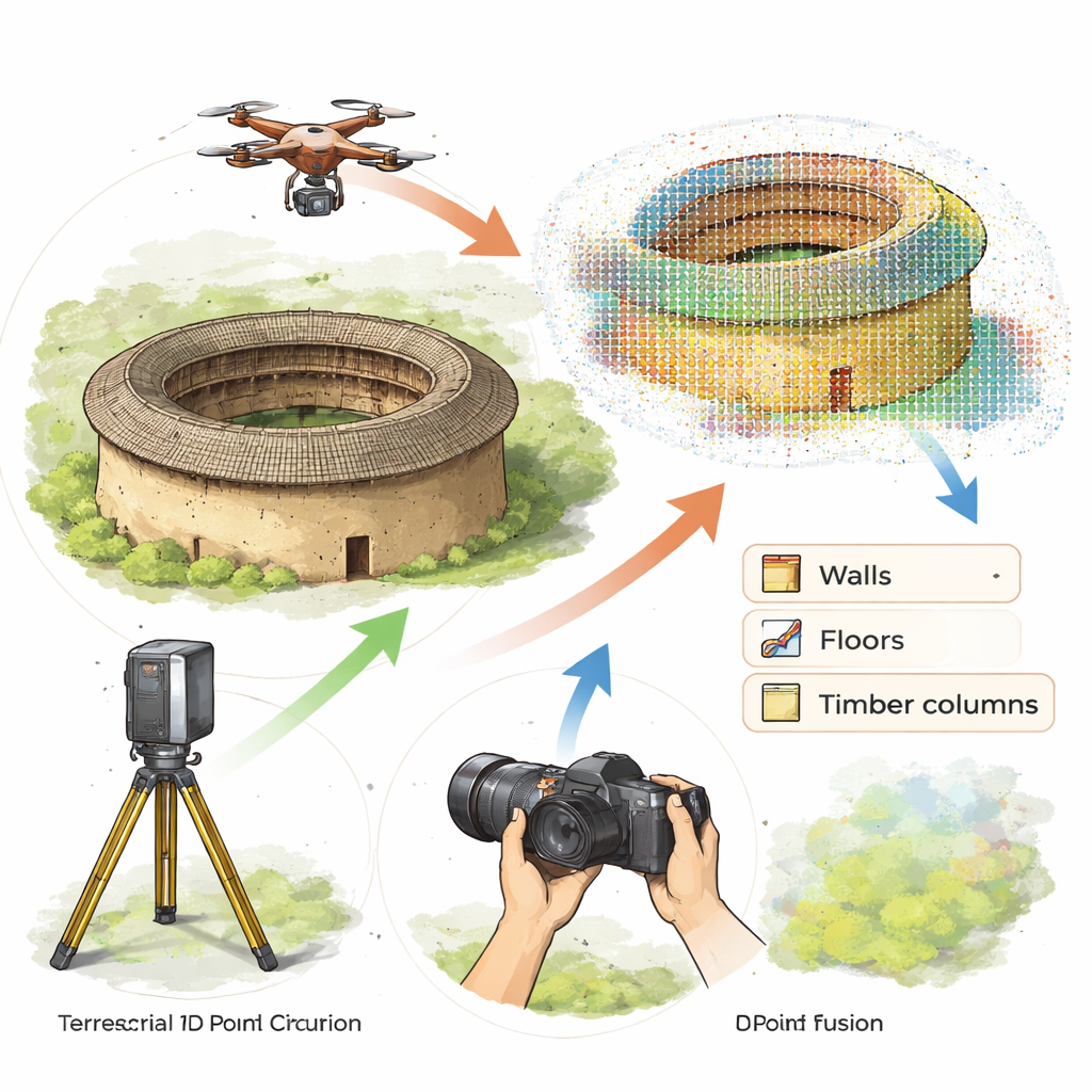
To move beyond tape measures and visual guesswork, the researchers combined three non-contact tools: a ground-based 3D laser scanner, a camera-carrying drone, and handheld digital cameras. The scanner sweeps the Tulou from the ground with millions of laser pulses, recording exact positions of points on the walls and structure down to millimeters. The drone flies above and around the building, taking overlapping photos that can be turned into a 3D model, especially capturing roofs and upper walls that the ground scanner cannot see. Handheld cameras add close-up detail of textures and surface damage. Using specialized software, the team carefully aligned these different datasets so they fit together like layers in a single, highly detailed digital twin of Jinjiang Tulou.
Making big data lean enough to read
Such a digital twin contains billions of points—too many to analyze directly and efficiently. The team tested several ways to thin this “point cloud” without losing important detail. In random sampling, a computer keeps only some of the points at chance; in spatial sampling, points that lie too close together are trimmed to leave an even grid; in intensity-weighted sampling, points are chosen based on how strong the laser’s return signal was. By comparing the resulting models of a single wooden column, they found that spatial sampling preserved the column’s true shape best, while intensity-based sampling smoothed away important dips and bumps. This careful pruning step allowed the researchers to keep just enough data to see small deformations clearly, while keeping processing times workable.
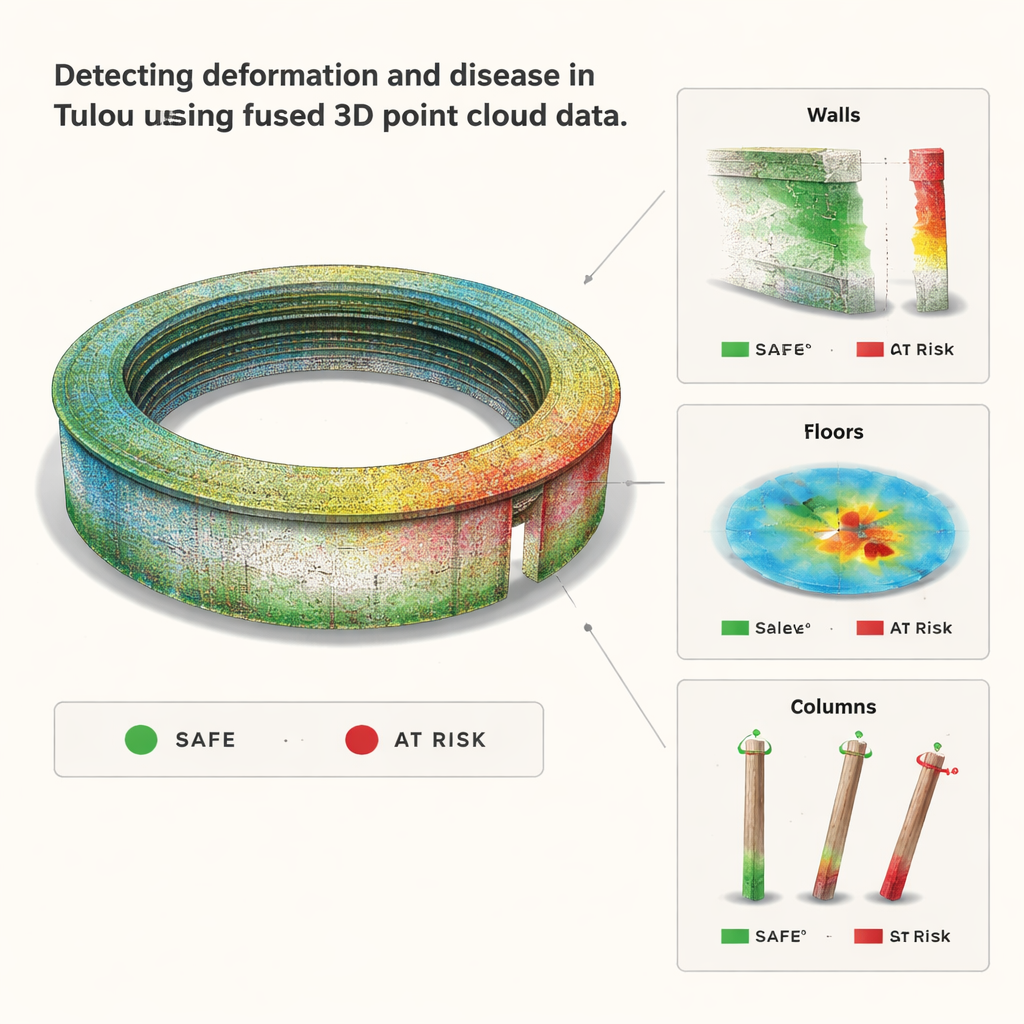
Reading cracks, tilts, and uneven floors
With the streamlined 3D model in hand, the team treated the Tulou as if it were being checked on a factory production line. For the earthen ring wall, they sliced the model into horizontal and vertical sections and fitted each slice to an ideal geometric shape—essentially asking, “How round and vertical would this wall be if it were perfect?” They then measured how far the real wall strayed from that ideal. The results showed that large parts of the exterior wall no longer match a clean circle and lean more than recommended limits in many places. On the second-floor walkway, a color-coded height map revealed raised and sunken tiles, confirming the visible bulges and cracks. For the timber columns, the researchers fitted ideal cylinders to the top and bottom of each column and compared their center points. The tiny horizontal offsets translated into small tilt angles; all six test columns stayed within national safety standards, indicating that the wooden frame remains structurally sound despite visible age.
What this means for saving earthen heritage
For non-specialists, the central message is that we can now “see” how an ancient building is deforming in ways too subtle for the naked eye, and do so without touching or harming it. By turning Jinjiang Tulou into a precise 3D dataset, the study shows how heritage guardians can move from subjective impressions—“the wall looks fine” or “that crack seems worrying”—to measured values for wall tilt, floor unevenness, and column lean. The authors argue that these digital baselines can anchor long-term monitoring, feed into digital building records, and even train artificial-intelligence tools to recognize early signs of trouble. In short, industrial-grade 3D measurement, once reserved for new construction and manufacturing, is becoming a powerful ally in keeping vulnerable earthen landmarks like Tulou safe, stable, and alive.
Citation: Zhang, J., Zou, S., Zhang, W. et al. Deformation and disease detection of Tulou based on multi-source 3D point cloud fusion. npj Herit. Sci. 14, 66 (2026). https://doi.org/10.1038/s40494-026-02333-w
Keywords: Fujian Tulou, 3D laser scanning, UAV photogrammetry, heritage conservation, structural health monitoring