Clear Sky Science · en
A data model for the spatialized integration of archaeological excavation information from prehistoric sites
Digging Deeper into Ancient Lives
How did people live, farm, and build the first towns thousands of years ago, long before anyone kept written records? Archaeologists try to answer these questions by carefully excavating prehistoric sites, but the information they collect often ends up scattered across maps, drawings, lab reports, and tables. This article introduces a new way to weave all those fragments together into a single, smart map-based system, so that past landscapes and societies can be explored more like an interactive atlas than a pile of paper reports.
From Paper Records to Connected Pieces
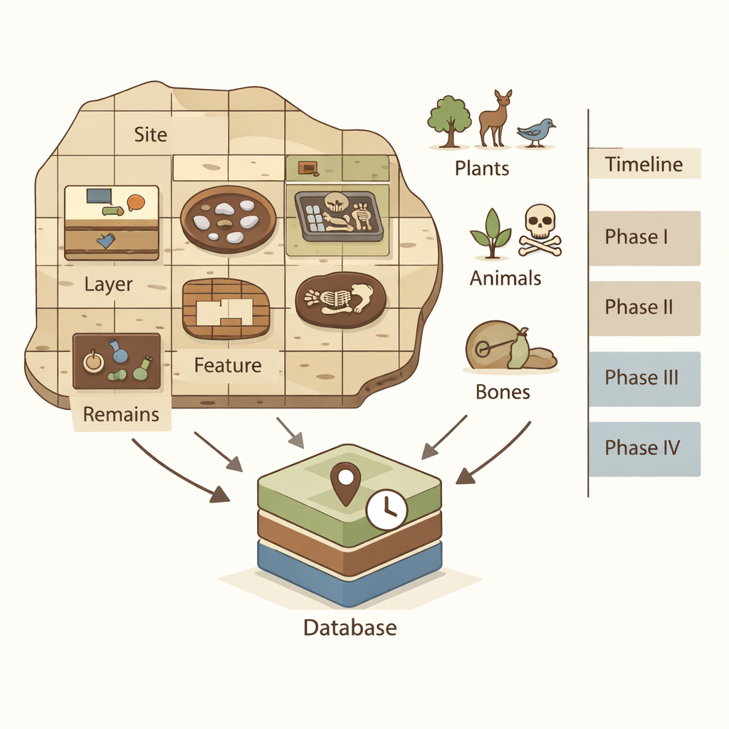
Traditional archaeological reports are rich in detail: they describe the trenches that were opened, the layers of soil, the pits and houses that were uncovered, the pots and tools found, and even seeds, animal bones, and human remains recovered for lab study. Yet these pieces are usually stored in separate databases or static text, making it hard to see how they connect in space and time. Many existing databases either ignore location altogether or record sites only as simple dots on a map, without capturing their shapes, internal layout, or the way different finds relate to one another vertically and horizontally.
Building a Five-Step Ladder into the Past
To solve this, the authors propose a structured “ladder” that connects every bit of information from the ground up: site → square unit → layer → feature → remain → cultural period. A site is the overall settlement; it is divided into a grid of square excavation units; within each square are stacked soil layers; inside layers are features such as ash pits, house foundations, tombs, trenches, and walls; and within those features lie the actual remains—artifacts, plant and animal bones, and human skeletons. Finally, all of this is tied to cultural phases, which mark when different ways of life and styles of objects appear and disappear. By treating each step on this ladder as a clearly defined object with location, shape, age, and descriptive attributes, the model turns a dig into a tightly linked spatial story.
Turning Finds into a Living Map
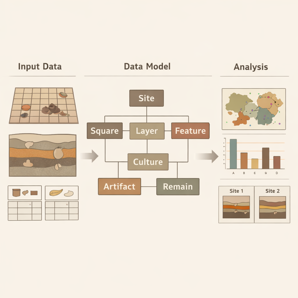
The researchers translated this ladder into a modern geographic information system (GIS) database. Some elements, like sites, excavation grids, and features, are stored as shapes on a digital map; others, like climate events or artifact categories, are stored as linked records. They tested the design using detailed reports from the Baodun site in southwest China, an early urban settlement of the Ancient Shu civilization. In their case study, a user can click on the site to read its basic information, zoom into specific squares, open profiles of soil layers, and then drill down to see which artifacts or plant remains were found in a particular pit or tomb, complete with pictures and descriptions.
What the New Model Can Reveal
Once information is structured this way, powerful analyses become possible. The team showed how drilling data could be used to map buried river deposits and infer the course of an ancient river that no longer exists on the surface. They counted and compared artifacts across individual grid squares, revealing how stone tools and pottery were distributed within the settlement. They also summarized plant remains, such as different kinds of rice grains and spikelets, by feature, helping to reconstruct farming and food practices. By linking two different sites—Baodun and a nearby site called Gaoshan—through shared artifact types and layer positions, the model helped refine their relative ages and supported the idea that Gaoshan began slightly earlier than Baodun.
Why This Matters for Understanding the Past
For non-specialists, the key message is that archaeology is becoming more like data-rich environmental science. Instead of treating each excavation report as an isolated book, this model works like a flexible, layered map that connects where something was found, how deep it was, what it was, and when it belonged. That makes it easier to compare sites, track changes through time, and ask new questions about how early communities spread, farmed, and adapted to their environments. Although the authors note that future work is needed to handle fully three-dimensional layers and more specialized lab data, their approach lays a practical digital foundation for turning scattered field notes into an integrated, searchable picture of prehistoric life.
Citation: Hou, T., Li, Y., Hu, D. et al. A data model for the spatialized integration of archaeological excavation information from prehistoric sites. npj Herit. Sci. 14, 45 (2026). https://doi.org/10.1038/s40494-026-02316-x
Keywords: prehistoric archaeology, GIS, spatiotemporal data model, archaeological database, ancient settlements