Clear Sky Science · en
HGIS based analysis of urban morphological evolution in historic Kaifeng
Why this buried city still shapes our future
Beneath the modern streets of Kaifeng in central China lie the stacked remains of at least six earlier cities, from imperial capitals to provincial strongholds. By carefully reconstructing how this urban maze expanded, shrank, and spread again over a thousand years, the authors show that historic cities are not frozen in time. Instead, they are living organisms shaped by politics, floods, and changing transport systems—and understanding that long story can help today’s planners avoid erasing the very heritage they seek to protect.
A city built on layers of time
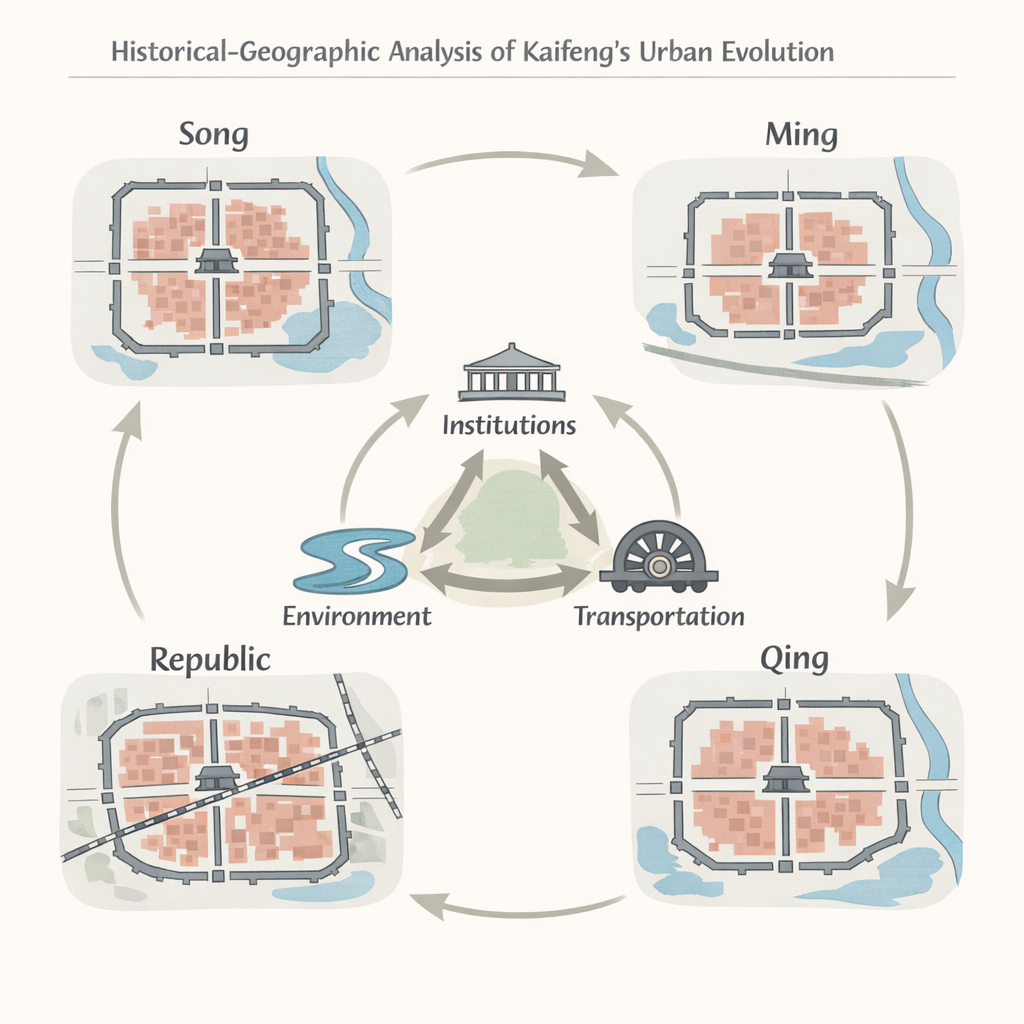
Kaifeng is famous as the Northern Song dynasty capital portrayed in classical scrolls, but its importance continued for centuries as its role in China’s political system rose and fell. Because the city stayed in roughly the same location on the Yellow River floodplain, each era tended to rebuild on top of the last. Archaeological digs reveal overlapping walls, palaces, markets, and neighborhoods—a textbook example of an “urban palimpsest,” where old layouts are partly erased yet still legible under newer plans. The study asks: how exactly did Kaifeng’s outline, street network, and main activity zones change from the Northern Song through the Ming and Qing dynasties into the Republic of China, and why?
Turning old maps into a time machine
To answer that, the researchers treated history like a giant spatial puzzle. They combined excavation reports, old maps, local chronicles, and prior reconstructions inside a Historical Geographic Information System, or HGIS. First, they aligned maps from four key periods to a modern coordinate grid, using remains of city walls, gates, rivers, and major landmarks as anchor points. Then they traced the outlines of built-up areas, street networks, waterways, and clusters of buildings serving different roles—administrative, commercial, religious, and residential. With this digital time series, they could measure how compact or stretched the city became, how clearly its streets guided movement, and where daily life and commerce were concentrated.
From ordered grid to tangled corridors
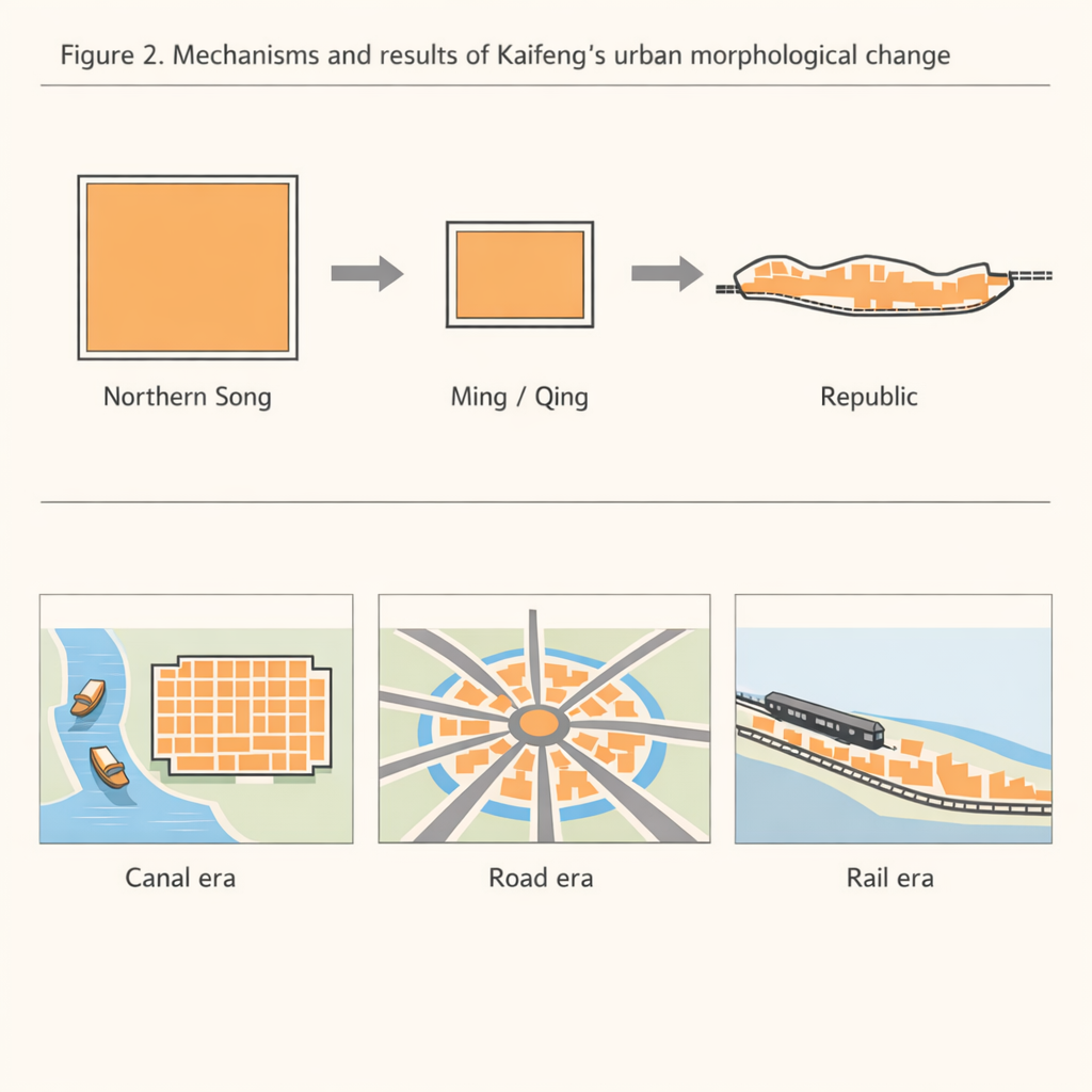
The picture that emerges is of a city in three broad phases: expansion, contraction, and renewed growth. In the Northern Song, Kaifeng filled a large, nearly rectangular area enclosed by three nested walls. A grand north–south avenue and key east–west streets created a highly readable cross-shaped skeleton that matched imperial ritual rules; people could easily infer the whole plan from any one street. After wars, political downgrading, and repeated Yellow River floods in the Ming and Qing, the city retreated to a smaller, more compact core. Lakes formed inside the old footprint, canals silted up, and streets began to bend around new water bodies. The grid loosened into a more organic pattern with several centers instead of one. By the early 20th century, the arrival of railways pulled development beyond the old walls, stretching the city into band-like corridors along tracks and main roads and making the street system noticeably harder to “read” at a glance.
Shifting functions: from river markets to rail hubs
Just as striking is how the city’s “hot spots” moved. In the imperial era, power sat firmly in the palace precinct at the center, while trade clustered along busy canals such as the Bian River. Markets, inns, and entertainment venues formed lively belts around bridge crossings, turning Kaifeng into a river city where boats fed local streets. As canals declined and floods reshaped the landscape, commerce and administration migrated inward and then northward, latching onto surviving gates and major crossroads such as the Drum Tower area. By the Republic of China period, shops and services still thrived in these traditional cores, but fresh clusters sprang up around the new railway station and outward roads. Religious compounds and housing followed a similar path: first spread widely, then packed into the inner city, and finally edging past the walls as modern urban growth resumed.
Why these patterns matter today
Behind these shifts, the authors identify a three-way engine driving Kaifeng’s form: state power set the basic scale and status of the city; the Yellow River and local water system nudged its outline and internal barriers; and transport technology—boats, carts, then trains—decided where people and goods actually flowed. Together, these forces produced the layered, sometimes fragile fabric that conservationists now aim to protect. The study argues that if we treat historic districts as living systems shaped by such long-term interactions, rather than as static museum pieces, we can design new roads, river works, and buildings that respect old spatial logics instead of erasing them. In Kaifeng and similar East Asian cities, this means preserving key axes, water corridors, and temple–market–residential patterns while allowing carefully guided renewal around them.
Citation: Zhu, Y., Huang, Y. HGIS based analysis of urban morphological evolution in historic Kaifeng. npj Herit. Sci. 14, 32 (2026). https://doi.org/10.1038/s40494-026-02299-9
Keywords: historic urban morphology, Kaifeng, historical GIS, urban heritage conservation, Yellow River floods